TopoQuest Logo
Do you find TopoQuest useful?
Help keep TopoQuest running and adding new maps/features by donating!
Bitcoin:  19c7KJd3qBynnjoSw5npx9KScwjBe4ifkT
Litecoin:  LXs6TkuXGGXo1vDsWCkWVdjQX94eUKd6ui
Home View Maps Find Maps Find Places Resources & Links


Pineview NW, Georgia Topographic Map

USGS Map Title: Pineview NW, GA
USGS Map MRC: 32083B6
DRG (GeoTIFF) Download: o32083b6.tif


Neighboring USGS Topographic Map Quads:


  Henderson, GA  
32083C7
 

  Unadilla, GA  
32083C6
 

  Klondike, GA  
32083C5
 

  Pinehurst, GA  
32083B7
 

  Pineview NW, GA  
32083B6
 

  Finleyson West, GA  
32083B5
 

  Vienna, GA  
32083A7
 

  Pineview SW, GA  
32083A6
 

  Pineview West, GA  
32083A5


Map MRC Location:

N33°
W84°
N33°
W83°
H8 H7 H6 H5 H4 H3 H2 H1
G8 G7 G6 G5 G4 G3 G2 G1
F8 F7 F6 F5 F4 F3 F2 F1
E8 E7 E6 E5 E4 E3 E2 E1
D8 D7 D6 D5 D4 D3 D2 D1
C8 C7 C6 C5 C4 C3 C2 C1
B8 B7 B6 B5 B4 B3 B2 B1
A8 A7 A6 A5 A4 A3 A2 A1
N32°
W84°
N32°
W83°

Pineview NW, GA USGS 1:24K Topographic Map Preview:
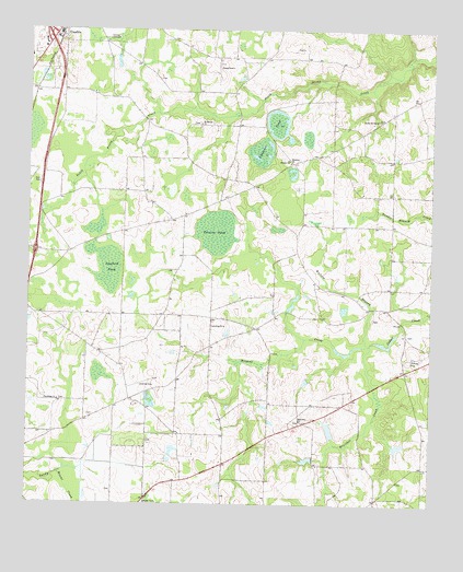
Pineview NW, GA USGS Topographic Map
Click on map above to begin viewing in our Map Viewer.

This topographic map contains these locations and features:
Feature Name Type Latitude Longitude GNIS ID View Map
Alligator PondLakeN32.2218°W83.6738°310488View Map
Bratcher CreekStreamN32.1671°W83.6435°311739View Map
Brown PondReservoirN32.1456°W83.6567°341608View Map
Brown Pond DamDamN32.1435°W83.6549°341607View Map
Browns ChapelChurchN32.2335°W83.7299°335195View Map
Daniels PondReservoirN32.1370°W83.6628°341610View Map
Daniels Pond DamDamN32.1368°W83.6616°341609View Map
Dooly County Fire Department Third District StationBuildingN32.2161°W83.6640°2604323View Map
Dunaway School (historical)SchoolN32.1774°W83.6355°335208View Map
Exit 38CrossingN32.1918°W83.7477°1672972View Map
Exit 39CrossingN32.2488°W83.7441°1672973View Map
Griggs South DamDamN32.2468°W83.6516°340246View Map
Griggs South LakeReservoirN32.2477°W83.6532°340247View Map
Harmony Baptist ChurchChurchN32.2141°W83.6682°356180View Map
Holly Grove ChurchChurchN32.1652°W83.6741°335223View Map
Joiner CemeteryCemeteryN32.1702°W83.6321°335224View Map
Layfield PondLakeN32.1854°W83.7235°316706View Map
Mars Hill CemeteryCemeteryN32.1468°W83.6652°335231View Map
Mars Hill ChurchChurchN32.1471°W83.6652°1704991View Map
Mars Hill CrossroadsPopulated PlaceN32.1468°W83.6638°1704992View Map
Mars Hill School (historical)SchoolN32.1468°W83.6646°1704993View Map
McCallayChurchN32.1463°W83.6649°317715View Map
Mount Moriah CemeteryCemeteryN32.2254°W83.6971°335237View Map
Mount Moriah ChurchChurchN32.2235°W83.6960°318695View Map
Peavy DamDamN32.1402°W83.6366°340248View Map
Peavy LakeReservoirN32.1405°W83.6347°340249View Map
Pine Ridge CemeteryCemeteryN32.1524°W83.7399°335246View Map
Pine Ridge Primitive Baptist ChurchChurchN32.1507°W83.7402°320644View Map
Pocosin PondLakeN32.1946°W83.6910°320961View Map
Poplar Spring CemeteryCemeteryN32.2254°W83.6416°335250View Map
Poplar Springs ChurchChurchN32.2249°W83.6416°321040View Map
Posey Airport (historical)AirportN32.2399°W83.6913°1672977View Map
Saint Pauls Church (historical)ChurchN32.1335°W83.6938°335259View Map
Smyrna CemeteryCemeteryN32.2163°W83.6716°335265View Map
Smyrna ChurchChurchN32.2141°W83.6693°323177View Map
Unadilla DivisionCivilN32.2325°W83.7345°1936607View Map
Union High School (historical)SchoolN32.1743°W83.6896°335271View Map
Wallace BranchStreamN32.1671°W83.6435°324795View Map
Wildcat CreekStreamN32.1671°W83.6435°325270View Map
Williams School (historical)SchoolN32.2052°W83.6421°335278View Map

Note: Coordinates in the location and feature list above are referenced to NAD83 datum.


Copyright (C) 2008-2024 Ryan Niemi / Sunset Dynamics ... All Rights Reserved