TopoQuest Logo
Do you find TopoQuest useful?
Help keep TopoQuest running and adding new maps/features by donating!
Bitcoin:  19c7KJd3qBynnjoSw5npx9KScwjBe4ifkT
Litecoin:  LXs6TkuXGGXo1vDsWCkWVdjQX94eUKd6ui
Home View Maps Find Maps Find Places Resources & Links


Pipe Creek, Texas Topographic Map

USGS Map Title: Pipe Creek, TX
USGS Map MRC: 29098F8
DRG (GeoTIFF) Download: o29098f8.tif


Neighboring USGS Topographic Map Quads:


  Bandera Pass, TX  
29099G1
 

  Turkey Knob, TX  
29098G8
 

  Ranger Creek, TX  
29098G7
 

  Bandera, TX  
29099F1
 

  Pipe Creek, TX  
29098F8
 

  Jack Mountain, TX  
29098F7
 

  Timber Creek, TX  
29099E1
 

  Medina Lake, TX  
29098E8
 

  San Geronimo, TX  
29098E7


Map MRC Location:

N30°
W99°
N30°
W98°
H8 H7 H6 H5 H4 H3 H2 H1
G8 G7 G6 G5 G4 G3 G2 G1
F8 F7 F6 F5 F4 F3 F2 F1
E8 E7 E6 E5 E4 E3 E2 E1
D8 D7 D6 D5 D4 D3 D2 D1
C8 C7 C6 C5 C4 C3 C2 C1
B8 B7 B6 B5 B4 B3 B2 B1
A8 A7 A6 A5 A4 A3 A2 A1
N29°
W99°
N29°
W98°

Pipe Creek, TX USGS 1:24K Topographic Map Preview:
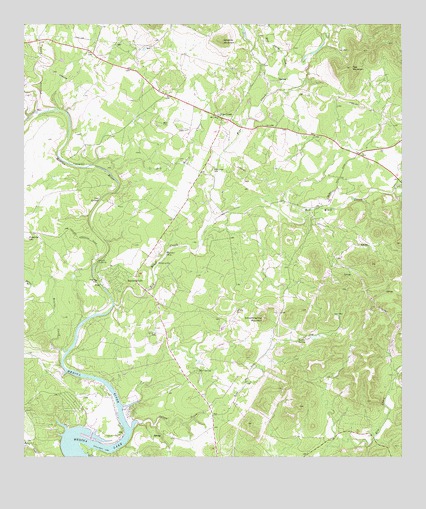
Pipe Creek, TX USGS Topographic Map
Click on map above to begin viewing in our Map Viewer.

This topographic map contains these locations and features:
Feature Name Type Latitude Longitude GNIS ID View Map
Bandera FallsPopulated PlaceN29.6772°W98.9634°1330002View Map
Barnes BranchStreamN29.6747°W98.9975°1330053View Map
Bear Springs CreekStreamN29.7294°W98.9200°1372124View Map
Bowl SpringSpringN29.6502°W98.9426°1331139View Map
Bruins CreekStreamN29.6552°W98.9864°1372757View Map
Cap MountainSummitN29.7377°W98.8920°1332125View Map
Coal SpringsSpringN29.6994°W98.9750°1333028View Map
Cold SpringsSpringN29.6919°W98.9920°1998592View Map
Dry Hollow CreekStreamN29.7094°W98.9775°1334697View Map
Edwards MountainSummitN29.7455°W98.9345°1335123View Map
English CrossingPopulated PlaceN29.6816°W98.9759°1378264View Map
Fivemile HillSummitN29.6883°W98.9989°1335862View Map
Lake Medina Shores Census Designated PlaceCensusN29.6384°W98.9869°2586947View Map
LakehillsPopulated PlaceN29.7233°W98.9350°2034974View Map
Lakeshore Volunteer Fire DepartmentBuildingN29.6320°W98.9688°2552020View Map
Medina River Ranch AirportAirportN29.6616°W98.9564°1387323View Map
Norton SpringSpringN29.6589°W98.9097°1342891View Map
Pipe CreekStreamN29.6941°W98.9375°1375484View Map
Pipe CreekPopulated PlaceN29.7236°W98.9359°1344123View Map
Pipe Creek CemeteryCemeteryN29.7083°W98.9378°1344124View Map
Pipe Creek Post OfficePost OfficeN29.7235°W98.9344°2731699View Map
Pipe Creek Volunteer Fire DepartmentBuildingN29.7064°W98.9417°2551937View Map
Privilege CreekStreamN29.7249°W98.9964°1375570View Map
Red Bluff CreekStreamN29.6691°W98.9706°1375658View Map
Smoothing Iron MountainSummitN29.6652°W98.9209°1347305View Map
Spires CreekStreamN29.6330°W98.9645°1347660View Map
Taylors Saddle Mountain Ranch Airport (historical)AirportN29.7044°W98.9756°1386335View Map
Wonder HoleLakeN29.6840°W98.9531°1350500View Map

Note: Coordinates in the location and feature list above are referenced to NAD83 datum.


Copyright (C) 2008-2025 Ryan Niemi / Sunset Dynamics ... All Rights Reserved