TopoQuest Logo
Do you find TopoQuest useful?
Help keep TopoQuest running and adding new maps/features by donating!
Bitcoin:  19c7KJd3qBynnjoSw5npx9KScwjBe4ifkT
Litecoin:  LXs6TkuXGGXo1vDsWCkWVdjQX94eUKd6ui
Home View Maps Find Maps Find Places Resources & Links


Ranger Creek, Texas Topographic Map

USGS Map Title: Ranger Creek, TX
USGS Map MRC: 29098G7
DRG (GeoTIFF) Download: o29098g7.tif


Neighboring USGS Topographic Map Quads:


  Comfort, TX  
29098H8
 

  Waring, TX  
29098H7
 

  Sisterdale, TX  
29098H6
 

  Turkey Knob, TX  
29098G8
 

  Ranger Creek, TX  
29098G7
 

  Boerne, TX  
29098G6
 

  Pipe Creek, TX  
29098F8
 

  Jack Mountain, TX  
29098F7
 

  Van Raub, TX  
29098F6


Map MRC Location:

N30°
W99°
N30°
W98°
H8 H7 H6 H5 H4 H3 H2 H1
G8 G7 G6 G5 G4 G3 G2 G1
F8 F7 F6 F5 F4 F3 F2 F1
E8 E7 E6 E5 E4 E3 E2 E1
D8 D7 D6 D5 D4 D3 D2 D1
C8 C7 C6 C5 C4 C3 C2 C1
B8 B7 B6 B5 B4 B3 B2 B1
A8 A7 A6 A5 A4 A3 A2 A1
N29°
W99°
N29°
W98°

Ranger Creek, TX USGS 1:24K Topographic Map Preview:
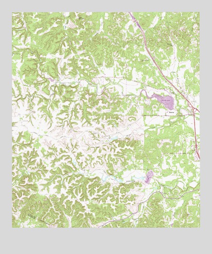
Ranger Creek, TX USGS Topographic Map
Click on map above to begin viewing in our Map Viewer.

This topographic map contains these locations and features:
Feature Name Type Latitude Longitude GNIS ID View Map
711 Ranch LakeReservoirN29.8021°W98.8071°1859618View Map
711 Ranch Lake DamDamN29.8019°W98.8053°1859617View Map
Agricultural Heritage MuseumBuildingN29.8208°W98.7517°2014538View Map
Boerne Wastewater Treatment PlantBuildingN29.8166°W98.7717°2044478View Map
Cannon HillSummitN29.8466°W98.7892°1353758View Map
Cedar MountainSummitN29.8719°W98.8317°1373024View Map
Cibolo Nature CenterBuildingN29.8208°W98.7517°2014539View Map
Comanche SpringSpringN29.8282°W98.7674°1354835View Map
Dantziger MonumentCemeteryN29.8087°W98.8158°2495897View Map
Deep Hollow CreekStreamN29.7747°W98.7770°1355822View Map
Easter CreekStreamN29.8191°W98.7600°1356767View Map
KONO-FM (Fredericksburg)TowerN29.8408°W98.8259°1387977View Map
Lake OzReservoirN29.7783°W98.7868°1364663View Map
Lake Oz DamDamN29.7786°W98.7870°1859619View Map
Masters LakeReservoirN29.7775°W98.8037°1865513View Map
Masters Lake DamDamN29.7769°W98.8020°1865512View Map
Ranger CreekStreamN29.8155°W98.7559°1366011View Map
Smith Investment Company Lake Number 1ReservoirN29.7787°W98.8135°1865509View Map
Smith Investment Company Lake Number 1 DamDamN29.7802°W98.8120°1865508View Map
Smith Investment Company Lake Number 3ReservoirN29.7797°W98.8079°1865511View Map
Smith Investment Company Lake Number 3 DamDamN29.7786°W98.8070°1865510View Map
Soil Conservation Service Site 1 DamDamN29.8269°W98.7696°1863040View Map
Soil Conservation Service Site 1 ReservoirReservoirN29.8241°W98.7744°1863041View Map
Soil Conservation Service Site 2 DamDamN29.8069°W98.7903°1863815View Map
Soil Conservation Service Site 2 ReservoirReservoirN29.8062°W98.7912°1863816View Map
Soil Conservation Service Site 3 DamDamN29.7786°W98.7836°1863373View Map
Soil Conservation Service Site 3 ReservoirReservoirN29.7786°W98.7836°1863374View Map
Soil Conservation Service Site 4 DamDamN29.7602°W98.7886°1863817View Map
Soil Conservation Service Site 4 ReservoirReservoirN29.7589°W98.7892°1863818View Map
Spanish PassGapN29.8566°W98.7684°1368872View Map
Sycamore Ridge CampLocaleN29.8347°W98.8364°1369508View Map
Upper Cibolo Community CemeteryCemeteryN29.8376°W98.8073°2500980View Map

Note: Coordinates in the location and feature list above are referenced to NAD83 datum.


Copyright (C) 2008-2025 Ryan Niemi / Sunset Dynamics ... All Rights Reserved