TopoQuest Logo
Do you find TopoQuest useful?
Help keep TopoQuest running and adding new maps/features by donating!
Bitcoin:  19c7KJd3qBynnjoSw5npx9KScwjBe4ifkT
Litecoin:  LXs6TkuXGGXo1vDsWCkWVdjQX94eUKd6ui
Home View Maps Find Maps Find Places Resources & Links


Pipestem, West Virginia Topographic Map

USGS Map Title: Pipestem, WV
USGS Map MRC: 37080E8
DRG (GeoTIFF) Download: o37080e8.tif


Neighboring USGS Topographic Map Quads:


  Shady Spring, WV  
37081F1
 

  Hinton, WV  
37080F8
 

  Talcott, WV  
37080F7
 

  Flat Top, WV  
37081E1
 

  Pipestem, WV  
37080E8
 

  Forest Hill, WV  
37080E7
 

  Athens, WV  
37081D1
 

  Lerona, WV  
37080D8
 

  Peterstown, WV  
37080D7


Map MRC Location:

N38°
W81°
N38°
W80°
H8 H7 H6 H5 H4 H3 H2 H1
G8 G7 G6 G5 G4 G3 G2 G1
F8 F7 F6 F5 F4 F3 F2 F1
E8 E7 E6 E5 E4 E3 E2 E1
D8 D7 D6 D5 D4 D3 D2 D1
C8 C7 C6 C5 C4 C3 C2 C1
B8 B7 B6 B5 B4 B3 B2 B1
A8 A7 A6 A5 A4 A3 A2 A1
N37°
W81°
N37°
W80°

Pipestem, WV USGS 1:24K Topographic Map Preview:
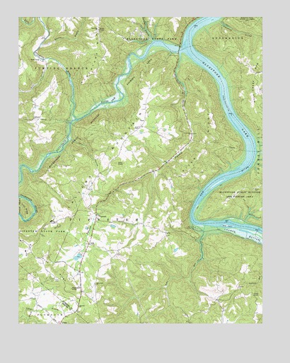
Pipestem, WV USGS Topographic Map
Click on map above to begin viewing in our Map Viewer.

This topographic map contains these locations and features:
Feature Name Type Latitude Longitude GNIS ID View Map
Barton CemeteryCemeteryN37.5548°W80.8790°1535292View Map
Bertha School (historical)SchoolN37.5787°W80.8815°1556891View Map
Bluestone LakeReservoirN37.6002°W80.8969°1550403View Map
Bluestone Lake Wildlife Management AreaParkN37.5590°W80.8804°1550404View Map
Bluestone MountainSummitN37.6029°W80.9612°1536145View Map
Bluestone National Scenic RiverParkN37.5658°W80.9837°1877617View Map
Bluestone RiverStreamN37.6123°W80.9145°1550405View Map
Bluestone River DistrictCivilN37.5876°W80.9581°1928170View Map
Bluestone State ParkParkN37.6182°W80.9359°1536147View Map
Buffalo CreekStreamN37.5407°W80.8840°1536624View Map
Buffalo School (historical)SchoolN37.5446°W80.8806°1556898View Map
Bull FallsFallsN37.5426°W80.9106°1556899View Map
Bull Falls Camping AreaLocaleN37.5393°W80.9090°1536694View Map
CarewPopulated PlaceN37.5148°W80.8873°1554072View Map
Clark KnobSummitN37.5107°W80.8759°1554139View Map
Cooks ChapelChurchN37.5329°W80.9634°1537600View Map
Davy KnobSummitN37.5657°W80.9493°1538067View Map
EllisonPopulated PlaceN37.5840°W80.9918°1554390View Map
Falling Rock School (historical)SchoolN37.6162°W80.9868°1556912View Map
FarleyPopulated PlaceN37.5360°W80.9240°1549679View Map
Farley School (historical)SchoolN37.5285°W80.9481°1556913View Map
Fourmile HollowValleyN37.6235°W80.8962°1539184View Map
Greenbrier ChurchChurchN37.5776°W80.9112°1539699View Map
Haines Ferry (historical)CrossingN37.6087°W80.9087°1556921View Map
James ChapelChurchN37.5801°W80.9379°1540810View Map
Jordans ChapelChurchN37.5540°W80.9623°1556934View Map
Knob RidgeRidgeN37.5207°W80.9834°1541273View Map
Knob Ridge School (historical)SchoolN37.5326°W80.9926°1556941View Map
Lilly (historical)Populated PlaceN37.5835°W80.9748°1556946View Map
Lilly BridgeBridgeN37.6117°W80.9176°2647429View Map
Little Bluestone RiverStreamN37.5835°W80.9698°1542035View Map
Long Branch LakeReservoirN37.5251°W80.9915°1559306View Map
Parker CreekStreamN37.6248°W80.9890°1544582View Map
Pine Grove School (historical)SchoolN37.5096°W80.9995°1557304View Map
PipestemPopulated PlaceN37.5446°W80.9601°1549875View Map
Pipestem Christian AcademySchoolN37.5336°W80.9640°2088314View Map
Pipestem ChurchChurchN37.5073°W80.9690°1544950View Map
Pipestem CreekStreamN37.6101°W80.9168°1544951View Map
Pipestem Golf Club Par 3 CourseLocaleN37.5293°W80.9986°2634151View Map
Pipestem Golf Club Regulation CourseLocaleN37.5467°W80.9798°2634153View Map
Pipestem Grade School (historical)SchoolN37.5457°W80.9618°1557368View Map
Pipestem KnobSummitN37.5146°W80.9729°1555365View Map
Pipestem Post OfficePost OfficeN37.5298°W80.9653°1559466View Map
Pipestem School (historical)SchoolN37.5132°W80.9606°1556962View Map
Pipestem State ParkParkN37.5398°W80.9943°1544952View Map
Pipestem Volunteer Fire DepartmentBuildingN37.5324°W80.9597°2577857View Map
Pleasant View School (historical)SchoolN37.5801°W80.9373°1556965View Map
Ridge School (historical)SchoolN37.5646°W80.9101°1556969View Map
River RidgeRidgeN37.5732°W80.9004°1545772View Map
Rockymount ChurchChurchN37.5165°W80.9609°1546038View Map
Sand KnobSummitN37.6193°W80.9590°1546364View Map
Sand Knob ChurchChurchN37.6201°W80.9587°1546365View Map
Sand Knob School (historical)SchoolN37.6146°W80.9584°1556973View Map
Snider CemeteryCemeteryN37.5783°W80.9246°2586365View Map
Steer IslandIslandN37.5401°W80.8929°1547375View Map
Suck CreekStreamN37.6085°W80.9840°1547618View Map
Suck CreekPopulated PlaceN37.6079°W80.9870°1549943View Map
Sun Valley LakeReservoirN37.5251°W80.9698°1559308View Map
Sun Valley Lake DamDamN37.5251°W80.9698°1559307View Map
Sunrise BranchStreamN37.6140°W80.9881°1547756View Map
Surveyor BranchStreamN37.6157°W80.9301°1547774View Map
Sycamore School (historical)SchoolN37.6176°W80.9329°1556983View Map
Tallery MountainSummitN37.5657°W80.9493°1547880View Map
Toms RunStreamN37.5401°W80.9043°1548144View Map
Tony HollowValleyN37.5754°W80.9726°1548170View Map
TruePopulated PlaceN37.5807°W80.9362°1549960View Map
True Post OfficePost OfficeN37.5796°W80.9379°1559480View Map
True School (historical)SchoolN37.5962°W80.9151°1556986View Map
Warford (historical)Populated PlaceN37.5376°W80.9048°1556989View Map

Note: Coordinates in the location and feature list above are referenced to NAD83 datum.


Copyright (C) 2008-2025 Ryan Niemi / Sunset Dynamics ... All Rights Reserved