TopoQuest Logo
Do you find TopoQuest useful?
Help keep TopoQuest running and adding new maps/features by donating!
Bitcoin:  19c7KJd3qBynnjoSw5npx9KScwjBe4ifkT
Litecoin:  LXs6TkuXGGXo1vDsWCkWVdjQX94eUKd6ui
Home View Maps Find Maps Find Places Resources & Links


Forest Hill, West Virginia Topographic Map

USGS Map Title: Forest Hill, WV
USGS Map MRC: 37080E7
DRG (GeoTIFF) Download: o37080e7.tif


Neighboring USGS Topographic Map Quads:


  Hinton, WV  
37080F8
 

  Talcott, WV  
37080F7
 

  Alderson, WV  
37080F6
 

  Pipestem, WV  
37080E8
 

  Forest Hill, WV  
37080E7
 

  Greenville, WV  
37080E6
 

  Lerona, WV  
37080D8
 

  Peterstown, WV  
37080D7
 

  Lindside, WV  
37080D6


Map MRC Location:

N38°
W81°
N38°
W80°
H8 H7 H6 H5 H4 H3 H2 H1
G8 G7 G6 G5 G4 G3 G2 G1
F8 F7 F6 F5 F4 F3 F2 F1
E8 E7 E6 E5 E4 E3 E2 E1
D8 D7 D6 D5 D4 D3 D2 D1
C8 C7 C6 C5 C4 C3 C2 C1
B8 B7 B6 B5 B4 B3 B2 B1
A8 A7 A6 A5 A4 A3 A2 A1
N37°
W81°
N37°
W80°

Forest Hill, WV USGS 1:24K Topographic Map Preview:
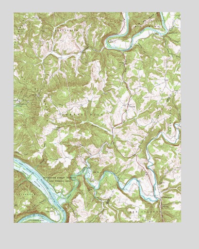
Forest Hill, WV USGS Topographic Map
Click on map above to begin viewing in our Map Viewer.

This topographic map contains these locations and features:
Feature Name Type Latitude Longitude GNIS ID View Map
Bargers SpringSpringN37.6146°W80.7587°1557801View Map
Bargers SpringsPopulated PlaceN37.6143°W80.7579°1535214View Map
Bennett School (historical)SchoolN37.6157°W80.8673°1556890View Map
BerthaPopulated PlaceN37.5726°W80.8709°1553870View Map
Bethlehem ChurchChurchN37.5235°W80.7656°1535729View Map
Blue LickStreamN37.6143°W80.7601°1536129View Map
Bluestone Conference CenterLocaleN37.5721°W80.8706°1536142View Map
Bradshaw CreekStreamN37.5321°W80.8201°1536291View Map
Bradshaw School (historical)SchoolN37.5462°W80.8034°1556897View Map
BuckPopulated PlaceN37.6018°W80.8240°1549615View Map
Bunker HillSummitN37.5196°W80.8195°1536720View Map
Calvary ChurchChurchN37.5285°W80.7748°1536869View Map
Camp LightfootLocaleN37.6076°W80.8042°1536933View Map
Camp SummersLocaleN37.6051°W80.7859°1556901View Map
Crumps BottomBendN37.5318°W80.8701°1537885View Map
Crumps BottomPopulated PlaceN37.5085°W80.8445°1554234View Map
Dickinson HollowValleyN37.5323°W80.8595°1538180View Map
Fairview Baptist Church CemeteryCemeteryN37.5706°W80.7920°2586179View Map
Fairview ChurchChurchN37.5704°W80.7917°1538803View Map
Fairview School (historical)SchoolN37.5087°W80.7809°1556655View Map
Fitz RunStreamN37.5140°W80.7676°1551119View Map
Forest HillPopulated PlaceN37.5701°W80.7895°1549689View Map
Forest Hill Methodist ChurchChurchN37.5704°W80.7887°1558040View Map
Forest Hill Post OfficePost OfficeN37.5728°W80.7883°1559435View Map
Forest Hill Volunteer Fire DepartmentBuildingN37.5775°W80.7867°2577916View Map
Foster School (historical)SchoolN37.5915°W80.8743°1556915View Map
Glenwood School (historical)SchoolN37.5560°W80.7565°1556661View Map
Greenbrier River DistrictCivilN37.6244°W80.8191°1928282View Map
Greenbrier School (historical)SchoolN37.6218°W80.7517°1556918View Map
Harmon School (historical)SchoolN37.5135°W80.8501°1556923View Map
Harvey FallsFallsN37.5035°W80.8520°1540046View Map
Horse Fork BranchStreamN37.5143°W80.8467°1540488View Map
Huffman CemeteryCemeteryN37.6082°W80.8373°1540558View Map
Indian CreekStreamN37.5179°W80.8459°1540670View Map
Indian MillsPopulated PlaceN37.5285°W80.8170°1554767View Map
Indian Mills Missionary Baptist ChurchChurchN37.5315°W80.8176°1558042View Map
Indian Mills Post OfficePost OfficeN37.5310°W80.8167°1559444View Map
Johnnycake ForkStreamN37.5512°W80.8004°1540955View Map
Joshuas RunStreamN37.5293°W80.8612°1541030View Map
Junta (historical)Populated PlaceN37.5171°W80.8384°1556937View Map
Kate HollowValleyN37.6021°W80.8465°1541078View Map
Kissinger RunStreamN37.6062°W80.7865°1541250View Map
Lick School (historical)SchoolN37.5182°W80.8148°1556945View Map
Little Stony CreekStreamN37.6115°W80.7648°1542231View Map
Low Gap ChurchChurchN37.5757°W80.8573°1542503View Map
Low Gap School (historical)SchoolN37.5721°W80.8462°1556948View Map
Lowell BranchStreamN37.5579°W80.7512°1542519View Map
MariePopulated PlaceN37.5837°W80.7615°1542760View Map
Mount Carman ChurchChurchN37.5004°W80.7745°1543619View Map
Mount Olive ChurchChurchN37.5012°W80.7762°1543701View Map
Mount Zion ChurchChurchN37.6215°W80.8576°1543807View Map
Neff School (historical)SchoolN37.5954°W80.8526°1556953View Map
New Hope ChurchChurchN37.5779°W80.7526°1544120View Map
New Hope Church CemeteryCemeteryN37.5774°W80.7525°2586364View Map
Pleasant View School (historical)SchoolN37.5979°W80.7620°1556964View Map
Red Sulphur SpringSpringN37.5101°W80.7654°1557712View Map
Red Sulphur SpringsLocaleN37.5137°W80.7651°1545467View Map
Red Sulphur Springs Methodist ChurchChurchN37.5179°W80.7662°1558752View Map
Roles Chapel Baptist ChurchChurchN37.5551°W80.8417°1558053View Map
SeminolePopulated PlaceN37.5551°W80.8417°1549920View Map
Spruce RunStreamN37.6021°W80.7937°1547265View Map
Spruce Run ChurchChurchN37.5943°W80.7926°1547278View Map
Spruce Run School (historical)SchoolN37.5948°W80.7920°1556977View Map
Stinking Lick CreekStreamN37.5204°W80.8145°1553060View Map
Stony CreekStreamN37.6118°W80.7623°1547492View Map
Stony Creek GorgeValleyN37.6110°W80.7615°1556979View Map
Turner School (historical)SchoolN37.6090°W80.8223°1556987View Map
Wheel RunStreamN37.5387°W80.8173°1548989View Map
Wheel Run School (historical)SchoolN37.5479°W80.8401°1556990View Map
Windydale School (historical)SchoolN37.5029°W80.7767°1556724View Map
Wolf CreekStreamN37.6057°W80.8054°1549265View Map
Wolf Creek MountainSummitN37.5668°W80.8526°1549274View Map

Note: Coordinates in the location and feature list above are referenced to NAD83 datum.


Copyright (C) 2008-2024 Ryan Niemi / Sunset Dynamics ... All Rights Reserved