TopoQuest Logo
Do you find TopoQuest useful?
Help keep TopoQuest running and adding new maps/features by donating!
Bitcoin:  19c7KJd3qBynnjoSw5npx9KScwjBe4ifkT
Litecoin:  LXs6TkuXGGXo1vDsWCkWVdjQX94eUKd6ui
Home View Maps Find Maps Find Places Resources & Links


Peterstown, West Virginia Topographic Map

USGS Map Title: Peterstown, WV
USGS Map MRC: 37080D7
DRG (GeoTIFF) Download: o37080d7.tif


Neighboring USGS Topographic Map Quads:


  Pipestem, WV  
37080E8
 

  Forest Hill, WV  
37080E7
 

  Greenville, WV  
37080E6
 

  Lerona, WV  
37080D8
 

  Peterstown, WV  
37080D7
 

  Lindside, WV  
37080D6
 

  Oakvale, WV  
37080C8
 

  Narrows, VA  
37080C7
 

  Pearisburg, VA  
37080C6


Map MRC Location:

N38°
W81°
N38°
W80°
H8 H7 H6 H5 H4 H3 H2 H1
G8 G7 G6 G5 G4 G3 G2 G1
F8 F7 F6 F5 F4 F3 F2 F1
E8 E7 E6 E5 E4 E3 E2 E1
D8 D7 D6 D5 D4 D3 D2 D1
C8 C7 C6 C5 C4 C3 C2 C1
B8 B7 B6 B5 B4 B3 B2 B1
A8 A7 A6 A5 A4 A3 A2 A1
N37°
W81°
N37°
W80°

Peterstown, WV USGS 1:24K Topographic Map Preview:
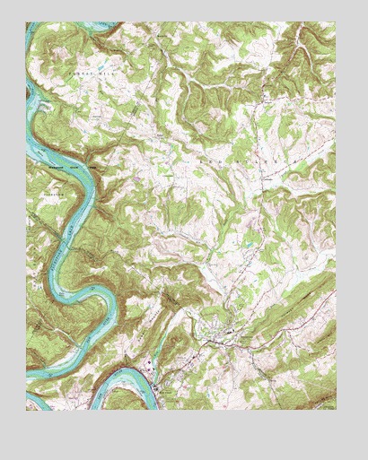
Peterstown, WV USGS Topographic Map
Click on map above to begin viewing in our Map Viewer.

This topographic map contains these locations and features:
Feature Name Type Latitude Longitude GNIS ID View Map
Adair CemeteryCemeteryN37.3837°W80.8340°1481257View Map
BallardPopulated PlaceN37.4748°W80.7792°1550160View Map
Ballard Christian SchoolSchoolN37.4971°W80.7726°2088125View Map
Ballard ChurchChurchN37.4848°W80.7781°1550161View Map
Ballard Post OfficePost OfficeN37.4738°W80.7796°1559402View Map
Ballard Volunteer Fire DepartmentBuildingN37.4704°W80.7829°2577614View Map
Bee BranchStreamN37.4862°W80.8173°1550235View Map
BozooPopulated PlaceN37.4629°W80.8223°1550436View Map
Bozoo Christian ChurchChurchN37.4626°W80.8212°1558730View Map
Bozoo Post OfficePost OfficeN37.4632°W80.8229°1559403View Map
Brush CreekStreamN37.3993°W80.8062°1550494View Map
CashmerePopulated PlaceN37.4498°W80.7798°1550643View Map
Cashmere Methodist ChurchChurchN37.4501°W80.7770°1558732View Map
Cedar BranchStreamN37.4998°W80.8467°1550661View Map
Chestnut FlatsFlatN37.4751°W80.8142°1556641View Map
Chestnut Hill School (historical)SchoolN37.4696°W80.8145°1556643View Map
Chimney RidgeRidgeN37.4093°W80.7648°1550703View Map
CloverdalePopulated PlaceN37.4501°W80.8154°1554160View Map
Cloverdale School (historical)SchoolN37.4485°W80.8217°1556644View Map
Cooper BranchStreamN37.3946°W80.8520°1550788View Map
Cooper BranchStreamN37.3948°W80.8517°1482696View Map
Crooked RunStreamN37.4262°W80.7998°1550840View Map
Crooked RunStreamN37.4771°W80.8709°1550841View Map
Dunn CemeteryCemeteryN37.4240°W80.7631°1550995View Map
First Baptist ChurchChurchN37.3823°W80.8220°1494547View Map
First Missionary Baptist ChurchChurchN37.4760°W80.7787°1558735View Map
Ford Hollow BranchStreamN37.4282°W80.8584°1483476View Map
Ford Hollow BranchStreamN37.4282°W80.8581°1551150View Map
Glen Lyn Bottom Ash Dikes DamDamN37.3751°W80.8665°1489857View Map
Glen Lyn Bottom Ash PondReservoirN37.3751°W80.8665°1489858View Map
Glen Lyn Police DepartmentBuildingN37.3764°W80.8536°2766943View Map
Glendale School (historical)SchoolN37.4468°W80.7512°1556660View Map
Gray Sulphur Springs (historical)Populated PlaceN37.3946°W80.7854°1501395View Map
Limestone CreekStreamN37.3754°W80.8465°1484846View Map
LurichPopulated PlaceN37.3810°W80.8409°1497001View Map
MandevillePopulated PlaceN37.4957°W80.8226°1555035View Map
Mandeville School (historical)SchoolN37.4896°W80.8331°1556950View Map
Manuel HollowValleyN37.3892°W80.8332°1488747View Map
MidwayPopulated PlaceN37.3915°W80.8081°1674434View Map
Midway ChurchChurchN37.3915°W80.8098°1485391View Map
Mount Carman CemeteryCemeteryN37.4943°W80.7698°1552194View Map
NeponsetPopulated PlaceN37.4685°W80.8462°1552288View Map
Peck School (historical)SchoolN37.4710°W80.8540°1556960View Map
PeterstownPopulated PlaceN37.3973°W80.7992°1552465View Map
Peterstown Airport (historical)AirportN37.4012°W80.8073°1558833View Map
Peterstown CemeteryCemeteryN37.3948°W80.8012°1674440View Map
Peterstown Church of GodChurchN37.4032°W80.7626°1558748View Map
Peterstown Elementary SchoolSchoolN37.4008°W80.7912°1556694View Map
Peterstown High School (historical)SchoolN37.4001°W80.7929°1556695View Map
Peterstown Middle SchoolSchoolN37.4002°W80.7928°2088306View Map
Peterstown Police DepartmentBuildingN37.3982°W80.7917°2728083View Map
Peterstown Post OfficePost OfficeN37.3975°W80.8000°2774604View Map
Peterstown Public LibraryBuildingN37.4011°W80.7919°2727355View Map
Peterstown Volunteer Fire DepartmentBuildingN37.3960°W80.7954°2577695View Map
Powell MountainSummitN37.4007°W80.8262°1486406View Map
Powell Mountain ChurchChurchN37.4126°W80.8198°1486407View Map
Red Sulphur SpringSpringN37.3846°W80.7734°1557710View Map
Red Sulphur SpringSpringN37.3779°W80.7734°1557711View Map
Rich CreekStreamN37.3829°W80.8245°1486582View Map
Rich CreekStreamN37.3829°W80.8248°1552642View Map
Rich CreekPopulated PlaceN37.3823°W80.8226°1497138View Map
Rich Creek Elementary SchoolSchoolN37.3885°W80.8234°1674443View Map
Rich Creek Police DepartmentBuildingN37.3883°W80.8234°2767130View Map
Rich Creek Post OfficePost OfficeN37.3826°W80.8224°2766277View Map
Rich Creek School (historical)SchoolN37.4276°W80.7504°1556701View Map
Rich Creek Volunteer Fire DepartmentBuildingN37.3817°W80.8230°2086272View Map
Roundbottom CreekStreamN37.4290°W80.8601°1552747View Map
Scott BranchStreamN37.3957°W80.7987°1552817View Map
Scott BranchStreamN37.3957°W80.7984°1486971View Map
Scott Branch SpringsSpringN37.3848°W80.7769°1557722View Map
Shanklins Ferry (historical)CrossingN37.4765°W80.8723°1556975View Map
Shanklins Ferry CampLocaleN37.4746°W80.8676°1552842View Map
Sherman Ballard Recreation AreaParkN37.4726°W80.8698°1552862View Map
Shues Bluff ChurchChurchN37.4218°W80.8015°1552887View Map
Smith BranchStreamN37.3879°W80.8676°1487328View Map
Thompson ChapelChurchN37.4926°W80.8265°1553214View Map
Town of PeterstownCivilN37.3990°W80.7950°2391358View Map
Town of Rich CreekCivilN37.3833°W80.8207°2391386View Map
Trigger RunStreamN37.3946°W80.7842°1553257View Map
White Tree HillSummitN37.4882°W80.7776°1556723View Map
Wylie FallsFallsN37.4118°W80.8620°1487101View Map
Wylie IslandIslandN37.4562°W80.8665°1553526View Map
Wylie MountainSummitN37.3971°W80.8115°1497140View Map

Note: Coordinates in the location and feature list above are referenced to NAD83 datum.


Copyright (C) 2008-2024 Ryan Niemi / Sunset Dynamics ... All Rights Reserved