TopoQuest Logo
Do you find TopoQuest useful?
Help keep TopoQuest running and adding new maps/features by donating!
Bitcoin:  19c7KJd3qBynnjoSw5npx9KScwjBe4ifkT
Litecoin:  LXs6TkuXGGXo1vDsWCkWVdjQX94eUKd6ui
Home View Maps Find Maps Find Places Resources & Links


Lerona, West Virginia Topographic Map

USGS Map Title: Lerona, WV
USGS Map MRC: 37080D8
DRG (GeoTIFF) Download: o37080d8.tif


Neighboring USGS Topographic Map Quads:


  Flat Top, WV  
37081E1
 

  Pipestem, WV  
37080E8
 

  Forest Hill, WV  
37080E7
 

  Athens, WV  
37081D1
 

  Lerona, WV  
37080D8
 

  Peterstown, WV  
37080D7
 

  Princeton, WV  
37081C1
 

  Oakvale, WV  
37080C8
 

  Narrows, VA  
37080C7


Map MRC Location:

N38°
W81°
N38°
W80°
H8 H7 H6 H5 H4 H3 H2 H1
G8 G7 G6 G5 G4 G3 G2 G1
F8 F7 F6 F5 F4 F3 F2 F1
E8 E7 E6 E5 E4 E3 E2 E1
D8 D7 D6 D5 D4 D3 D2 D1
C8 C7 C6 C5 C4 C3 C2 C1
B8 B7 B6 B5 B4 B3 B2 B1
A8 A7 A6 A5 A4 A3 A2 A1
N37°
W81°
N37°
W80°

Lerona, WV USGS 1:24K Topographic Map Preview:
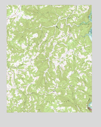
Lerona, WV USGS Topographic Map
Click on map above to begin viewing in our Map Viewer.

This topographic map contains these locations and features:
Feature Name Type Latitude Longitude GNIS ID View Map
Anderson RidgeRidgeN37.4896°W80.8912°1534947View Map
Bent MountainSummitN37.4471°W80.9759°1535651View Map
Big ForkStreamN37.4276°W80.9845°1535837View Map
Bird School (historical)SchoolN37.4532°W80.9695°1557125View Map
Bolars ForkStreamN37.4235°W80.9979°1536204View Map
Browns ChapelChurchN37.4990°W80.8968°1536430View Map
Browns RidgeRidgeN37.4854°W80.9659°1536439View Map
Browns Ridge School (historical)SchoolN37.4846°W80.9723°1557142View Map
Butler School (historical)SchoolN37.4587°W80.9351°1557146View Map
Caperton School (historical)SchoolN37.4021°W80.9576°1557151View Map
Cashers HillPopulated PlaceN37.4479°W80.8887°1557154View Map
Cashes Hill CemeteryCemeteryN37.4493°W80.8892°1557155View Map
Cashs HillSummitN37.4504°W80.8904°1554082View Map
Cashs Hill ChurchChurchN37.4487°W80.8887°1537085View Map
Chestnut KnobPopulated PlaceN37.4060°W80.9062°1549624View Map
Chestnut Knob School (historical)SchoolN37.4054°W80.9059°1557159View Map
Dry ForkStreamN37.4846°W80.9229°1538359View Map
Dugspur Rescue SquadBuildingN37.4103°W80.9933°2086376View Map
ElgoodPopulated PlaceN37.3996°W80.9312°1549671View Map
Elgood Grade School (historical)SchoolN37.3993°W80.9306°1557184View Map
Gore School (historical)SchoolN37.4479°W80.9009°1557205View Map
Green Springs ChurchChurchN37.4204°W80.8920°1539689View Map
Green Springs School (historical)SchoolN37.4201°W80.8806°1557213View Map
Greenrock School (historical)SchoolN37.4737°W80.9881°1557212View Map
Hackett CreekStreamN37.4757°W80.9287°1539822View Map
Hackett RidgeRidgeN37.4610°W80.9429°1539823View Map
Hill TopPopulated PlaceN37.4654°W80.9084°1549742View Map
Hilltop Baptist ChurchChurchN37.4662°W80.9084°1557109View Map
Island CreekStreamN37.4646°W80.8765°1540735View Map
Island Creek School (historical)SchoolN37.4626°W80.8920°1556931View Map
James RidgeRidgeN37.4693°W80.9198°1540816View Map
LeronaPopulated PlaceN37.4996°W80.9790°1554943View Map
Lerona Post OfficePost OfficeN37.4997°W80.9787°1559531View Map
Lerona-Speedway School (historical)SchoolN37.4996°W80.9787°1557247View Map
Liberty School (historical)SchoolN37.3865°W80.9615°1557248View Map
Lick CreekPopulated PlaceN37.4846°W80.9115°1549783View Map
Lick CreekStreamN37.4821°W80.8765°1541878View Map
Lick Creek School (historical)SchoolN37.4765°W80.9020°1556944View Map
Little Island CreekStreamN37.4546°W80.9115°1542132View Map
LovernPopulated PlaceN37.4343°W80.8754°1554921View Map
Martin School (historical)SchoolN37.4290°W80.9831°1557255View Map
McKenzie School (historical)SchoolN37.3912°W80.9290°1557260View Map
Mercers Saltworks (historical)Populated PlaceN37.4826°W80.8784°1556951View Map
Mountain View Community ChurchChurchN37.3996°W80.9304°1557283View Map
Mudhole School (historical)SchoolN37.4426°W80.9006°1557284View Map
Nash SpringSpringN37.3996°W80.9309°1557647View Map
Ovenlick CreekStreamN37.4726°W80.9490°1544480View Map
Panther Branch School (historical)SchoolN37.4871°W80.9204°1556957View Map
Parish Hill School (historical)SchoolN37.4243°W80.9276°1557297View Map
Pennington School (historical)SchoolN37.3835°W80.9345°1557299View Map
PettryPopulated PlaceN37.4362°W80.9640°1549873View Map
Pettry Post Office (historical)Post OfficeN37.4362°W80.9643°1559549View Map
Pleasant Hill School (historical)SchoolN37.3787°W80.8915°1557307View Map
Saltwell RidgeRidgeN37.4698°W80.8884°1552781View Map
Scratchgravel School (historical)SchoolN37.3754°W80.9095°1557332View Map
Stony RunStreamN37.4601°W80.9070°1547498View Map
Sun Rise ChapelChurchN37.4532°W80.9687°1547745View Map
Sun Valley Elementary SchoolSchoolN37.4848°W80.9979°1547746View Map
Thompson ChapelChurchN37.3868°W80.9254°1548047View Map
Tracy ForkStreamN37.4268°W80.9959°1548245View Map
Vest School (historical)SchoolN37.3896°W80.9267°1557352View Map
Whites ChapelChurchN37.4012°W80.9984°1549093View Map
Whites School (historical)SchoolN37.4007°W80.9895°1557359View Map
Wiley BranchStreamN37.4685°W80.9762°1549144View Map
Wiley School (historical)SchoolN37.4732°W80.9484°1557362View Map
Woodall ForkStreamN37.3843°W80.8992°1549367View Map

Note: Coordinates in the location and feature list above are referenced to NAD83 datum.


Copyright (C) 2008-2024 Ryan Niemi / Sunset Dynamics ... All Rights Reserved