TopoQuest Logo
Do you find TopoQuest useful?
Help keep TopoQuest running and adding new maps/features by donating!
Bitcoin:  19c7KJd3qBynnjoSw5npx9KScwjBe4ifkT
Litecoin:  LXs6TkuXGGXo1vDsWCkWVdjQX94eUKd6ui
Home View Maps Find Maps Find Places Resources & Links


Pireway, North Carolina Topographic Map

USGS Map Title: Pireway, NC
USGS Map MRC: 34078A6
DRG (GeoTIFF) Download: o34078a6.tif


Neighboring USGS Topographic Map Quads:


  Tabor City East, NC  
34078B7
 

  Nakina, NC  
34078B6
 

  Old Dock, NC  
34078B5
 

  Goretown, SC  
34078A7
 

  Pireway, NC  
34078A6
 

  Freeland, NC  
34078A5
 

  Hammond, SC  
33078H7
 

  Longs, SC  
33078H6
 

  Calabash, NC  
33078H5


Map MRC Location:

N35°
W79°
N35°
W78°
H8 H7 H6 H5 H4 H3 H2 H1
G8 G7 G6 G5 G4 G3 G2 G1
F8 F7 F6 F5 F4 F3 F2 F1
E8 E7 E6 E5 E4 E3 E2 E1
D8 D7 D6 D5 D4 D3 D2 D1
C8 C7 C6 C5 C4 C3 C2 C1
B8 B7 B6 B5 B4 B3 B2 B1
A8 A7 A6 A5 A4 A3 A2 A1
N34°
W79°
N34°
W78°

Pireway, NC USGS 1:24K Topographic Map Preview:
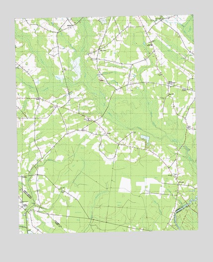
Pireway, NC USGS Topographic Map
Click on map above to begin viewing in our Map Viewer.

This topographic map contains these locations and features:
Feature Name Type Latitude Longitude GNIS ID View Map
BethelPopulated PlaceN34.1241°W78.7128°1006130View Map
Bethel CemeteryCemeteryN34.0943°W78.7164°981101View Map
Big BranchStreamN34.1021°W78.7036°1004730View Map
Big Cypress BridgeBridgeN34.0866°W78.6611°981383View Map
Big Cypress SwampStreamN34.0585°W78.6664°981384View Map
Briery BaySwampN34.1060°W78.6425°981892View Map
Bristol CreekStreamN34.0152°W78.6364°981917View Map
Bristol Creek ChurchChurchN34.0246°W78.7186°1004724View Map
Bug HillPopulated PlaceN34.0788°W78.6439°1019392View Map
Butler CrossroadsPopulated PlaceN34.0860°W78.6439°1006150View Map
Camp SwampLocaleN34.0157°W78.7472°1221269View Map
Camp SwampStreamN34.0029°W78.7445°982556View Map
Camp Swamp BridgeBridgeN34.0135°W78.7442°1221271View Map
Cane Break BridgesBridgeN34.0879°W78.7150°982584View Map
Carolina Bay AirportAirportN34.0961°W78.7200°2717072View Map
Club BaySwampN34.0307°W78.6572°983300View Map
Cox FieldAirportN34.0398°W78.7402°2679271View Map
Cross BaySwampN34.0166°W78.6800°983778View Map
DothanPopulated PlaceN34.0335°W78.7475°1006180View Map
DulahPopulated PlaceN34.0566°W78.6870°1006186View Map
Dulah Mormon ChurchChurchN34.0513°W78.6797°984408View Map
Eddie Ford BridgesBridgeN34.1241°W78.7034°984621View Map
Faith ChurchChurchN34.0813°W78.6267°1004729View Map
Gores ChapelChurchN34.0607°W78.6297°1004723View Map
Grissett SwampStreamN34.0571°W78.6614°986165View Map
GuidePopulated PlaceN34.0785°W78.7336°986189View Map
GuidewayPopulated PlaceN34.0646°W78.6958°986190View Map
Guideway Elementary SchoolSchoolN34.0656°W78.7004°1006494View Map
Happy Home ChurchChurchN34.1229°W78.6461°1004722View Map
Jackson BaySwampN34.0102°W78.7081°987486View Map
Jenrette BaySwampN34.0379°W78.7120°987568View Map
Juniper SwampStreamN34.0854°W78.7181°987857View Map
Maple BranchStreamN34.0913°W78.6931°989296View Map
Marlowe CemeteryCemeteryN34.0177°W78.7375°1224320View Map
Marsh BaySwampN34.0496°W78.6970°989364View Map
Monie SwampStreamN34.0816°W78.6967°990140View Map
Nakina ChurchChurchN34.1099°W78.6536°1004726View Map
Nakina Fire and Rescue SquadBuildingN34.1028°W78.6554°2638277View Map
Nakina Fire and Rescue Squad PirewayBuildingN34.0004°W78.6493°2639093View Map
Nakina High SchoolSchoolN34.1146°W78.6553°1006508View Map
Nakina High SchoolSchoolN34.1077°W78.6539°1004725View Map
New Light ChurchChurchN34.0260°W78.7203°1004728View Map
Old Zion ChurchChurchN34.0735°W78.7225°991622View Map
Open Door ChurchChurchN34.0841°W78.6425°1004727View Map
Pine LevelPopulated PlaceN34.1066°W78.6917°1006330View Map
Pine Level ChurchChurchN34.1010°W78.6931°992265View Map
PirewayPopulated PlaceN34.0271°W78.6378°992409View Map
Pleasant Union ChurchChurchN34.1152°W78.6767°992568View Map
Primitive ChurchChurchN34.0321°W78.6406°992818View Map
Ramsey Ford BridgesBridgeN34.0702°W78.6881°993020View Map
Riverside ChurchChurchN34.0321°W78.6417°993386View Map
Saint Stevens CemeteryCemeteryN34.0768°W78.6461°994141View Map
Sand Pit BranchStreamN34.1196°W78.6361°994231View Map
Seven Creek BridgesBridgeN34.0479°W78.6361°994509View Map
Seven CreeksPopulated PlaceN34.0821°W78.6300°1022546View Map
South Williams Fire DepartmentBuildingN34.1206°W78.7168°2639070View Map
Stack CemeteryCemeteryN34.0799°W78.6286°995389View Map
Township of Bug HillCivilN34.0434°W78.6732°1026573View Map
Whiskey SwampStreamN34.0821°W78.7414°997121View Map
Zion ChurchChurchN34.0674°W78.7367°997756View Map
Zion Plain ChurchChurchN34.0916°W78.6492°997808View Map

Note: Coordinates in the location and feature list above are referenced to NAD83 datum.


Copyright (C) 2008-2024 Ryan Niemi / Sunset Dynamics ... All Rights Reserved