TopoQuest Logo
Do you find TopoQuest useful?
Help keep TopoQuest running and adding new maps/features by donating!
Bitcoin:  19c7KJd3qBynnjoSw5npx9KScwjBe4ifkT
Litecoin:  LXs6TkuXGGXo1vDsWCkWVdjQX94eUKd6ui
Home View Maps Find Maps Find Places Resources & Links


Goretown, South Carolina Topographic Map

USGS Map Title: Goretown, SC
USGS Map MRC: 34078A7
DRG (GeoTIFF) Download: o34078a7.tif


Neighboring USGS Topographic Map Quads:


  Tabor City West, NC  
34078B8
 

  Tabor City East, NC  
34078B7
 

  Nakina, NC  
34078B6
 

  Loris, SC  
34078A8
 

  Goretown, SC  
34078A7
 

  Pireway, NC  
34078A6
 

  Shell, SC  
33078H8
 

  Hammond, SC  
33078H7
 

  Longs, SC  
33078H6


Map MRC Location:

N35°
W79°
N35°
W78°
H8 H7 H6 H5 H4 H3 H2 H1
G8 G7 G6 G5 G4 G3 G2 G1
F8 F7 F6 F5 F4 F3 F2 F1
E8 E7 E6 E5 E4 E3 E2 E1
D8 D7 D6 D5 D4 D3 D2 D1
C8 C7 C6 C5 C4 C3 C2 C1
B8 B7 B6 B5 B4 B3 B2 B1
A8 A7 A6 A5 A4 A3 A2 A1
N34°
W79°
N34°
W78°

Goretown, SC USGS 1:24K Topographic Map Preview:
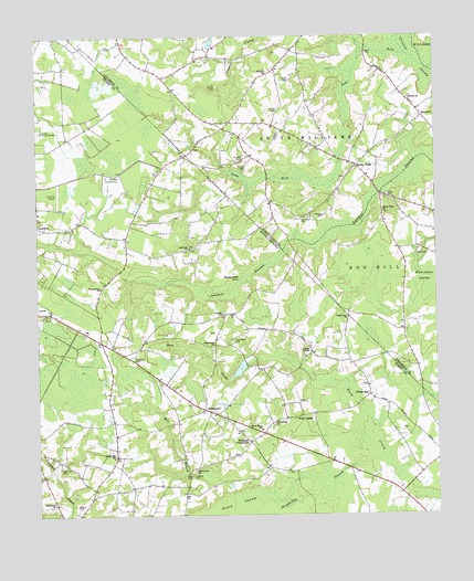
Goretown, SC USGS Topographic Map
Click on map above to begin viewing in our Map Viewer.

This topographic map contains these locations and features:
Feature Name Type Latitude Longitude GNIS ID View Map
Antioch CemeteryCemeteryN34.0104°W78.8267°1220210View Map
Carolina Country ClubLocaleN34.0888°W78.8489°1242365View Map
Cartrette CemeteryCemeteryN34.0774°W78.7917°982702View Map
Community ChurchChurchN34.0116°W78.8256°1243660View Map
Cox CemeteryCemeteryN34.0679°W78.7556°983666View Map
Flag Patch CemeteryCemeteryN34.0452°W78.8139°1222421View Map
Flag Patch ChurchChurchN34.0446°W78.8197°1222422View Map
Frieds BayPopulated PlaceN34.0310°W78.7711°1227902View Map
Glendale ChurchChurchN34.0760°W78.8747°1222720View Map
Gore CemeteryCemeteryN34.1204°W78.7711°985838View Map
GoretownPopulated PlaceN34.0268°W78.8211°1231333View Map
Grace Christian SchoolSchoolN34.0884°W78.8716°2486469View Map
Grahams CrossroadsPopulated PlaceN34.0196°W78.8086°1231335View Map
Hardee CemeteryCemeteryN34.1118°W78.8184°986388View Map
Holly Hill CemeteryCemeteryN34.0124°W78.8681°1223236View Map
Horry County Fire Department Station 26BuildingN34.0323°W78.8125°2368377View Map
Hughes Mill PondLakeN34.0618°W78.8108°1246097View Map
Hulls IslandPopulated PlaceN34.0266°W78.7889°1227921View Map
Hulls Island School (historical)SchoolN34.0252°W78.7947°1243784View Map
Ironhill ChurchChurchN34.1154°W78.8025°987402View Map
Lawn Dale ChurchChurchN34.0157°W78.8509°1246312View Map
Liberty TempleChurchN34.0429°W78.7895°1223896View Map
Loris Elementary SchoolSchoolN34.0504°W78.8631°1243820View Map
Loris High SchoolSchoolN34.0416°W78.8611°1243821View Map
Loris Middle SchoolSchoolN34.0286°W78.8547°2486446View Map
Macedonia ChurchChurchN34.0029°W78.8700°1224248View Map
Milligan CemeteryCemeteryN34.0782°W78.7850°990013View Map
Norris CemeteryCemeteryN34.0827°W78.7645°991187View Map
Northern Pines Golf ClubLocaleN34.0901°W78.8502°2490032View Map
Oak Dale Baptist ChurchChurchN34.0699°W78.8270°1225094View Map
Oak Dale School (historical)SchoolN34.0696°W78.8289°1243866View Map
Piney Grove ChurchChurchN34.0593°W78.8547°1225494View Map
Prince CemeteryCemeteryN34.1132°W78.7953°992822View Map
Reaves CemeteryCemeteryN34.0029°W78.8628°1250296View Map
Round SwampSwampN34.0027°W78.8131°1226050View Map
Sandy PlainPopulated PlaceN34.0913°W78.7747°1006364View Map
Sandy Plain ChurchChurchN34.0791°W78.7661°994292View Map
Sheepbridge BranchStreamN34.0152°W78.7700°1226550View Map
Smith CemeteryCemeteryN34.1057°W78.7992°994937View Map
SnowhillPopulated PlaceN34.1038°W78.7536°1006377View Map
Snowhill ChurchChurchN34.1088°W78.7581°995075View Map
Soles CemeteryCemeteryN34.1193°W78.7828°995100View Map
Springfield CemeteryCemeteryN34.0529°W78.8159°1226839View Map
Springfield ChurchChurchN34.0243°W78.8011°1251012View Map
Sweet Gum ChurchChurchN34.0516°W78.7775°1226992View Map
Sweet Home SchoolSchoolN34.0227°W78.8047°1226996View Map
Tabor City Fire Department SubstationBuildingN34.0912°W78.7740°2639582View Map
Toms ForkStreamN34.1199°W78.7578°996152View Map
Twin City AirportAirportN34.0878°W78.8703°1251930View Map
Twin City Memorial GardensCemeteryN34.1004°W78.8742°1251240View Map
Wild Cattle SwampSwampN34.0618°W78.7528°997300View Map
Wright CemeteryCemeteryN34.0927°W78.8106°997651View Map

Note: Coordinates in the location and feature list above are referenced to NAD83 datum.


Copyright (C) 2008-2024 Ryan Niemi / Sunset Dynamics ... All Rights Reserved