TopoQuest Logo
Do you find TopoQuest useful?
Help keep TopoQuest running and adding new maps/features by donating!
Bitcoin:  19c7KJd3qBynnjoSw5npx9KScwjBe4ifkT
Litecoin:  LXs6TkuXGGXo1vDsWCkWVdjQX94eUKd6ui
Home View Maps Find Maps Find Places Resources & Links


Tabor City East, North Carolina Topographic Map

USGS Map Title: Tabor City East, NC
USGS Map MRC: 34078B7
DRG (GeoTIFF) Download: o34078b7.tif


Neighboring USGS Topographic Map Quads:


  Cerro Gordo, NC  
34078C8
 

  Chadbourn, NC  
34078C7
 

  Whiteville, NC  
34078C6
 

  Tabor City West, NC  
34078B8
 

  Tabor City East, NC  
34078B7
 

  Nakina, NC  
34078B6
 

  Loris, SC  
34078A8
 

  Goretown, SC  
34078A7
 

  Pireway, NC  
34078A6


Map MRC Location:

N35°
W79°
N35°
W78°
H8 H7 H6 H5 H4 H3 H2 H1
G8 G7 G6 G5 G4 G3 G2 G1
F8 F7 F6 F5 F4 F3 F2 F1
E8 E7 E6 E5 E4 E3 E2 E1
D8 D7 D6 D5 D4 D3 D2 D1
C8 C7 C6 C5 C4 C3 C2 C1
B8 B7 B6 B5 B4 B3 B2 B1
A8 A7 A6 A5 A4 A3 A2 A1
N34°
W79°
N34°
W78°

Tabor City East, NC USGS 1:24K Topographic Map Preview:
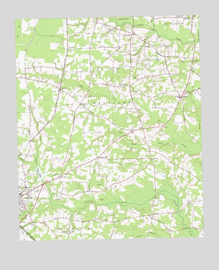
Tabor City East, NC USGS Topographic Map
Click on map above to begin viewing in our Map Viewer.

This topographic map contains these locations and features:
Feature Name Type Latitude Longitude GNIS ID View Map
Beaver DamLocaleN34.2407°W78.7956°980801View Map
Big Pond BayBayN34.2063°W78.7539°981437View Map
Big Pond BranchStreamN34.2357°W78.7509°1025153View Map
Black CreekStreamN34.1621°W78.8550°981521View Map
Boggy Hill BranchStreamN34.1693°W78.8667°981684View Map
Cedar BranchStreamN34.2416°W78.7795°982791View Map
ClarendonPopulated PlaceN34.2102°W78.8453°983208View Map
Clarendon ChurchChurchN34.2018°W78.8309°983209View Map
Clarendon Post OfficePost OfficeN34.2101°W78.8458°2774327View Map
Cribb CemeteryCemeteryN34.1974°W78.7931°983744View Map
Cribb CemeteryCemeteryN34.2207°W78.8070°983745View Map
Cribb TownPopulated PlaceN34.2113°W78.7981°1006169View Map
Cypress BranchStreamN34.1493°W78.8242°983874View Map
East TaborPopulated PlaceN34.1604°W78.8472°984542View Map
EmersonPopulated PlaceN34.1810°W78.8661°984761View Map
Emmanuel ChurchChurchN34.2493°W78.7642°984768View Map
Flat BayBayN34.1568°W78.8200°985150View Map
Forest Lawn ChurchChurchN34.1621°W78.8425°985285View Map
Fowler CemeteryCemeteryN34.1343°W78.8670°985348View Map
Graveyard BranchStreamN34.2463°W78.8053°985978View Map
Greenhouse BayBayN34.2246°W78.7784°986101View Map
Gum SwampStreamN34.1779°W78.7661°986237View Map
Hinson CemeteryCemeteryN34.1724°W78.8650°986847View Map
Hinson CemeteryCemeteryN34.2329°W78.7728°986848View Map
IronhillPopulated PlaceN34.1385°W78.7831°1006251View Map
Ironhill BranchStreamN34.1252°W78.7745°987401View Map
Lake TaborReservoirN34.1627°W78.8597°995823View Map
Lebanon ChurchChurchN34.2199°W78.7556°988262View Map
McPherson CemeteryCemeteryN34.2307°W78.7953°989646View Map
Meares CemeteryCemeteryN34.1874°W78.7750°989690View Map
Mill Branch ChurchChurchN34.1696°W78.7836°989891View Map
Mount Elgrim ChurchChurchN34.2485°W78.7570°990375View Map
Mount Sinai ChurchChurchN34.1863°W78.7981°990568View Map
Myrtle Green CemeteryCemeteryN34.1627°W78.8703°990827View Map
New LifePopulated PlaceN34.1307°W78.8409°1006311View Map
Norris CemeteryCemeteryN34.1743°W78.8736°991188View Map
Pentecostal Free Will Baptist ChurchChurchN34.2119°W78.8085°2506218View Map
Prince CemeteryCemeteryN34.2060°W78.7592°992823View Map
Rogers Field (historical)AirportN34.1468°W78.8456°997844View Map
RoselandPopulated PlaceN34.2327°W78.8395°1006353View Map
Roseland Volunteer Fire DepartmentBuildingN34.2329°W78.8390°2638633View Map
SidneyPopulated PlaceN34.1871°W78.7892°1006372View Map
Simons BranchStreamN34.1588°W78.8622°994847View Map
Skeebo BranchStreamN34.1460°W78.8550°994877View Map
Soles CemeteryCemeteryN34.1646°W78.8684°995101View Map
Spivey CemeteryCemeteryN34.1354°W78.8175°995307View Map
Spring BranchStreamN34.1402°W78.8389°995317View Map
Strouds BayBayN34.1468°W78.8184°995616View Map
Sweet Water BranchStreamN34.2421°W78.7814°995781View Map
Tabor City Emergency ServicesBuildingN34.1529°W78.8680°2720385View Map
Tabor City Police DepartmentBuildingN34.1550°W78.8622°2130852View Map
Tabor City Post OfficePost OfficeN34.1494°W78.8744°2505395View Map
Tabor City Wastewater Treatment PlantLocaleN34.1498°W78.8564°2506019View Map
Todd CemeteryCemeteryN34.2057°W78.8236°996124View Map
Torry BayBayN34.2149°W78.7945°996172View Map
Town of Tabor CityCivilN34.1540°W78.8739°2406708View Map
Township of South WilliamsCivilN34.1327°W78.8241°1026579View Map
Township of WilliamsCivilN34.1878°W78.7887°1026585View Map
Vinegar HillPopulated PlaceN34.1713°W78.8203°996633View Map
WilliamsPopulated PlaceN34.2043°W78.7628°997356View Map
Williams Township High SchoolSchoolN34.2041°W78.7639°1006496View Map
Williams Township Volunteer Fire DepartmentBuildingN34.2053°W78.7632°2638965View Map
WKSM-FM (Tabor City)TowerN34.1502°W78.8609°1018612View Map
WTAB-AM (Tabor City)TowerN34.1502°W78.8609°1018352View Map

Note: Coordinates in the location and feature list above are referenced to NAD83 datum.


Copyright (C) 2008-2024 Ryan Niemi / Sunset Dynamics ... All Rights Reserved