TopoQuest Logo
Do you find TopoQuest useful?
Help keep TopoQuest running and adding new maps/features by donating!
Bitcoin:  19c7KJd3qBynnjoSw5npx9KScwjBe4ifkT
Litecoin:  LXs6TkuXGGXo1vDsWCkWVdjQX94eUKd6ui
Home View Maps Find Maps Find Places Resources & Links


Bethlehem, Mississippi Topographic Map

USGS Map Title: Bethlehem, MS
USGS Map MRC: 34089E3
DRG (GeoTIFF) Download: o34089e3.tif


Neighboring USGS Topographic Map Quads:


  Waterford, MS  
34089F4
 

  Potts Camp, MS  
34089F3
 

  Chilli Creek, MS  
34089F2
 

  Malone, MS  
34089E4
 

  Bethlehem, MS  
34089E3
 

  Hickory Flat, MS  
34089E2
 

  Bagley Lake, MS  
34089D4
 

  Puskus Lake, MS  
34089D3
 

  Etta, MS  
34089D2


Map MRC Location:

N35°
W90°
N35°
W89°
H8 H7 H6 H5 H4 H3 H2 H1
G8 G7 G6 G5 G4 G3 G2 G1
F8 F7 F6 F5 F4 F3 F2 F1
E8 E7 E6 E5 E4 E3 E2 E1
D8 D7 D6 D5 D4 D3 D2 D1
C8 C7 C6 C5 C4 C3 C2 C1
B8 B7 B6 B5 B4 B3 B2 B1
A8 A7 A6 A5 A4 A3 A2 A1
N34°
W90°
N34°
W89°

Bethlehem, MS USGS 1:24K Topographic Map Preview:
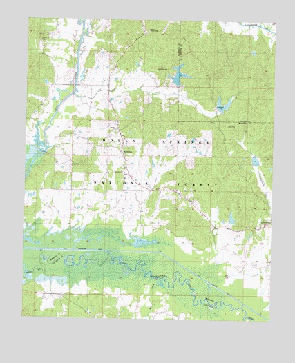
Bethlehem, MS USGS Topographic Map
Click on map above to begin viewing in our Map Viewer.

This topographic map contains these locations and features:
Feature Name Type Latitude Longitude GNIS ID View Map
Baker and Maxie Mill (historical)LocaleN34.5065°W89.2890°704815View Map
Baptist Hill CemeteryCemeteryN34.5629°W89.3509°692452View Map
Baptist Hill ChurchChurchN34.5629°W89.3509°692453View Map
BethlehemPopulated PlaceN34.5784°W89.3276°692567View Map
Bethlehem CemeteryCemeteryN34.5607°W89.3248°706300View Map
Bethlehem CemeteryCemeteryN34.5701°W89.3265°692568View Map
Bethlehem ChurchChurchN34.5609°W89.3254°692574View Map
Bethlehem ChurchChurchN34.5701°W89.3265°692576View Map
Bethlehem ChurchChurchN34.5840°W89.3298°692577View Map
Bethlehem SchoolSchoolN34.5804°W89.3287°692578View Map
Brent CemeteryCemeteryN34.5806°W89.2734°692699View Map
Brents LakeReservoirN34.5890°W89.2754°711483View Map
CornersvillePopulated PlaceN34.5390°W89.2556°692978View Map
Cornersville CemeteryCemeteryN34.5398°W89.2545°706306View Map
Cypress CreekStreamN34.5007°W89.2631°693038View Map
Goodmans Ferry (historical)CrossingN34.5173°W89.3062°704737View Map
Holly Springs National ForestForestN34.5729°W89.3072°711476View Map
Lebanon CemeteryCemeteryN34.6162°W89.3676°693699View Map
Little Tallahatchie CanalCanalN34.5284°W89.3395°693788View Map
Macedonia CemeteryCemeteryN34.6045°W89.3045°693855View Map
Macedonia ChurchChurchN34.6048°W89.3029°693862View Map
Mill CreekStreamN34.5101°W89.2695°692368View Map
Mount Ollie ChurchChurchN34.5762°W89.3262°704746View Map
Oaklimeter Watershed LT-8-21 DamDamN34.6134°W89.2651°695620View Map
Overton SchoolSchoolN34.5554°W89.3245°694283View Map
Potts Camp Volunteer Fire Department Bethlehem SubstationBuildingN34.5542°W89.3234°2665960View Map
Potts CreekStreamN34.5954°W89.3517°694466View Map
Rhea Lake DamDamN34.5634°W89.2551°695601View Map
RiversidePopulated PlaceN34.5098°W89.3626°706743View Map
Riverside ChurchChurchN34.5090°W89.3609°694567View Map
Riverside SchoolSchoolN34.5090°W89.3609°694569View Map
Robinson Lake DamDamN34.5384°W89.2684°695596View Map
Salem CemeteryCemeteryN34.5507°W89.2920°706323View Map
Salem ChurchChurchN34.5504°W89.2920°704753View Map
Salem ChurchChurchN34.5576°W89.2940°694684View Map
Spence BranchStreamN34.5201°W89.3637°704892View Map
Taylor Lake DamDamN34.6001°W89.3001°695618View Map
Tippah River Watershed LT-7-21 DamDamN34.5868°W89.2784°695612View Map
Wares Bridge (historical)BridgeN34.5690°W89.3654°704758View Map
Winborn Lookout TowerTowerN34.6212°W89.3126°711336View Map
Wolf CreekStreamN34.5143°W89.3020°695206View Map

Note: Coordinates in the location and feature list above are referenced to NAD83 datum.


Copyright (C) 2008-2025 Ryan Niemi / Sunset Dynamics ... All Rights Reserved