TopoQuest Logo
Do you find TopoQuest useful?
Help keep TopoQuest running and adding new maps/features by donating!
Bitcoin:  19c7KJd3qBynnjoSw5npx9KScwjBe4ifkT
Litecoin:  LXs6TkuXGGXo1vDsWCkWVdjQX94eUKd6ui
Home View Maps Find Maps Find Places Resources & Links


Potts Camp, Mississippi Topographic Map

USGS Map Title: Potts Camp, MS
USGS Map MRC: 34089F3
DRG (GeoTIFF) Download: o34089f3.tif


Neighboring USGS Topographic Map Quads:


  Holly Springs, MS  
34089G4
 

  Holly Springs SE, MS  
34089G3
 

  Ashland, MS  
34089G2
 

  Waterford, MS  
34089F4
 

  Potts Camp, MS  
34089F3
 

  Chilli Creek, MS  
34089F2
 

  Malone, MS  
34089E4
 

  Bethlehem, MS  
34089E3
 

  Hickory Flat, MS  
34089E2


Map MRC Location:

N35°
W90°
N35°
W89°
H8 H7 H6 H5 H4 H3 H2 H1
G8 G7 G6 G5 G4 G3 G2 G1
F8 F7 F6 F5 F4 F3 F2 F1
E8 E7 E6 E5 E4 E3 E2 E1
D8 D7 D6 D5 D4 D3 D2 D1
C8 C7 C6 C5 C4 C3 C2 C1
B8 B7 B6 B5 B4 B3 B2 B1
A8 A7 A6 A5 A4 A3 A2 A1
N34°
W90°
N34°
W89°

Potts Camp, MS USGS 1:24K Topographic Map Preview:
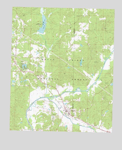
Potts Camp, MS USGS Topographic Map
Click on map above to begin viewing in our Map Viewer.

This topographic map contains these locations and features:
Feature Name Type Latitude Longitude GNIS ID View Map
Airs SchoolSchoolN34.7137°W89.3742°692380View Map
Bethany CemeteryCemeteryN34.7126°W89.3020°692546View Map
Bethany ChurchChurchN34.7126°W89.3015°692549View Map
Beulah Hill ChurchChurchN34.7429°W89.3337°692583View Map
Boatwright CemeteryCemeteryN34.6895°W89.3631°706301View Map
Bond Lake DamDamN34.6751°W89.3684°695645View Map
Brady BranchStreamN34.6809°W89.2681°692686View Map
Butler CemeteryCemeteryN34.6420°W89.3226°692784View Map
Chewalla ChurchChurchN34.6815°W89.3395°694339View Map
Chewalla CreekStreamN34.6593°W89.3295°692888View Map
Chewalla LakeReservoirN34.7322°W89.3370°704727View Map
Chewalla Organization CampLocaleN34.7426°W89.3306°692889View Map
Chewalla Recreation AreaParkN34.7320°W89.3412°704728View Map
Clayton CemeteryCemeteryN34.6959°W89.2698°704505View Map
Cox LakeReservoirN34.6953°W89.2896°711486View Map
Dickey Lake DamDamN34.6801°W89.2734°695648View Map
Drivers SchoolSchoolN34.7307°W89.2904°693109View Map
First Baptist ChurchChurchN34.6462°W89.3056°704735View Map
Harmony CemeteryCemeteryN34.7423°W89.2917°704515View Map
Hudspeth Lake DamDamN34.7301°W89.2884°695668View Map
Lake CenterPopulated PlaceN34.6890°W89.3584°704743View Map
Lake Center DamDamN34.6951°W89.3617°695660View Map
Lonoke (historical)LocaleN34.7223°W89.2506°705886View Map
Lonoke ChurchChurchN34.7229°W89.2509°693827View Map
LT 7-10 DamDamN34.6918°W89.2901°695657View Map
LT 7-10 LakeReservoirN34.6918°W89.2901°695658View Map
Mary Reid SchoolSchoolN34.6515°W89.3059°706314View Map
Moody (historical)LocaleN34.6904°W89.3431°704745View Map
New Hope SchoolSchoolN34.6307°W89.2637°694177View Map
Nichols Lake DamDamN34.6368°W89.2784°695627View Map
Oaklimeter CreekStreamN34.6565°W89.3262°694244View Map
Oaklimeter Watershed LT-8-35 DamDamN34.6401°W89.2584°682753View Map
Open Door Baptist ChurchChurchN34.6418°W89.3012°704750View Map
Pemberton CemeteryCemeteryN34.6812°W89.3395°694338View Map
Pine Mountain OverlookLocaleN34.7487°W89.3695°711508View Map
Potts CampPopulated PlaceN34.6462°W89.3054°694464View Map
Potts Camp CemeteryCemeteryN34.6501°W89.3103°694465View Map
Potts Camp CemeteryCemeteryN34.6415°W89.2987°706319View Map
Potts Camp Post OfficePost OfficeN34.6459°W89.3063°2768590View Map
Potts Camp SchoolSchoolN34.6432°W89.3029°706320View Map
Potts Camp Volunteer Fire DepartmentBuildingN34.6454°W89.3058°2665961View Map
Potts Camp Work CenterBuildingN34.6465°W89.3095°711509View Map
Reeds Gift ChurchChurchN34.6415°W89.3001°694546View Map
Saint Mary CemeteryCemeteryN34.6412°W89.3034°1959773View Map
Saint Mary ChurchChurchN34.6415°W89.3040°694656View Map
Saint Pauls CemeteryCemeteryN34.7140°W89.3740°694671View Map
Saint Pauls ChurchChurchN34.7145°W89.3737°694673View Map
Tacaleechi (historical)LocaleN34.6301°W89.2598°704539View Map
Temperance Hill CemeteryCemeteryN34.6798°W89.3428°706327View Map
Temperance Hill ChurchChurchN34.6807°W89.3429°694953View Map
Thompson Lake DamDamN34.6918°W89.2501°695656View Map
Tippah River Watershed LT-7-1 DamDamN34.7251°W89.3384°695665View Map
Town of Potts CampCivilN34.6492°W89.3064°2407152View Map
White Lake DamDamN34.7184°W89.3734°695662View Map
White Lake DamDamN34.7218°W89.3667°695664View Map
WinbornPopulated PlaceN34.6312°W89.2731°695191View Map

Note: Coordinates in the location and feature list above are referenced to NAD83 datum.


Copyright (C) 2008-2024 Ryan Niemi / Sunset Dynamics ... All Rights Reserved