TopoQuest Logo
Do you find TopoQuest useful?
Help keep TopoQuest running and adding new maps/features by donating!
Bitcoin:  19c7KJd3qBynnjoSw5npx9KScwjBe4ifkT
Litecoin:  LXs6TkuXGGXo1vDsWCkWVdjQX94eUKd6ui
Home View Maps Find Maps Find Places Resources & Links


Plantersville, Alabama Topographic Map

USGS Map Title: Plantersville, AL
USGS Map MRC: 32086F8
DRG (GeoTIFF) Download: o32086f8.tif


Neighboring USGS Topographic Map Quads:


  Oakmulgee, AL  
32087G1
 

  Maplesville West, AL  
32086G8
 

  Maplesville East, AL  
32086G7
 

  Buck Creek, AL  
32087F1
 

  Plantersville, AL  
32086F8
 

  Pletcher, AL  
32086F7
 

  Summerfield, AL  
32087E1
 

  Jones, AL  
32086E8
 

  Milton, AL  
32086E7


Map MRC Location:

N33°
W87°
N33°
W86°
H8 H7 H6 H5 H4 H3 H2 H1
G8 G7 G6 G5 G4 G3 G2 G1
F8 F7 F6 F5 F4 F3 F2 F1
E8 E7 E6 E5 E4 E3 E2 E1
D8 D7 D6 D5 D4 D3 D2 D1
C8 C7 C6 C5 C4 C3 C2 C1
B8 B7 B6 B5 B4 B3 B2 B1
A8 A7 A6 A5 A4 A3 A2 A1
N32°
W87°
N32°
W86°

Plantersville, AL USGS 1:24K Topographic Map Preview:
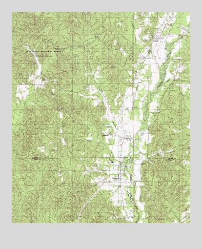
Plantersville, AL USGS Topographic Map
Click on map above to begin viewing in our Map Viewer.

This topographic map contains these locations and features:
Feature Name Type Latitude Longitude GNIS ID View Map
Ball Hill School (historical)SchoolN32.6429°W86.9511°162376View Map
Blue BranchStreamN32.7335°W86.9144°159206View Map
Boggles CreekStreamN32.7162°W86.8953°159224View Map
Chestnut Hill Church (historical)ChurchN32.7418°W86.9911°161796View Map
Chilton (historical)LocaleN32.7124°W86.9133°161797View Map
Corley Jones BridgeBridgeN32.6590°W86.9205°162377View Map
Dallas County High SchoolSchoolN32.6612°W86.9297°162378View Map
DixiePopulated PlaceN32.7232°W86.9058°159503View Map
Ebenezer ChurchChurchN32.7360°W86.9003°162928View Map
Gandy CreekStreamN32.7065°W86.8969°159652View Map
Harris BranchStreamN32.6601°W86.9203°159726View Map
Harris BranchStreamN32.6935°W86.9058°161798View Map
Harris CemeteryCemeteryN32.6785°W86.9486°159728View Map
Holdridges Mill (historical)LocaleN32.6329°W86.9039°162769View Map
J E Terry Elementary SchoolSchoolN32.6535°W86.9253°162380View Map
Lester BranchStreamN32.6674°W86.9108°161799View Map
Little Zion ChurchChurchN32.6287°W86.8753°159992View Map
Martin CreekStreamN32.6754°W86.9136°160042View Map
Martin FieldParkN32.6617°W86.9306°2356934View Map
Mount Zion CemeteryCemeteryN32.6671°W86.9989°151486View Map
Mount Zion ChurchChurchN32.6679°W86.9994°160184View Map
New Hope CemeteryCemeteryN32.6551°W86.9675°160235View Map
New Hope Christian ChurchChurchN32.6551°W86.9678°162382View Map
Oak Grove CemeteryCemeteryN32.6765°W86.9242°151488View Map
Oak Grove ChurchChurchN32.6776°W86.9294°161801View Map
ParnellPopulated PlaceN32.6949°W86.9147°160344View Map
Pickering LakeReservoirN32.6618°W86.9017°161308View Map
Pickering Lake DamDamN32.6618°W86.9017°161309View Map
Pine Flat SchoolSchoolN32.6529°W86.9228°147614View Map
PlantersvillePopulated PlaceN32.6568°W86.9244°160398View Map
Plantersville Christian CemeteryCemeteryN32.6553°W86.9243°151470View Map
Plantersville Grove ChurchChurchN32.6446°W86.9317°160399View Map
Plantersville Post OfficePost OfficeN32.6594°W86.9245°2789074View Map
Plantersville Volunteer Fire DepartmentBuildingN32.6568°W86.9316°2691276View Map
Price BranchStreamN32.7279°W86.9708°160445View Map
RidervillePopulated PlaceN32.6774°W86.9314°160487View Map
Spring Hill CemeteryCemeteryN32.7329°W86.9050°151489View Map
Spring Hill ChurchChurchN32.7335°W86.9055°161802View Map
StantonPopulated PlaceN32.7357°W86.8997°160667View Map
Stanton CemeteryCemeteryN32.7393°W86.9022°162931View Map
Stanton Christian SchoolSchoolN32.7346°W86.8947°162932View Map
Stanton ChurchChurchN32.7343°W86.9008°162933View Map
Stanton Post OfficePost OfficeN32.7352°W86.8982°2789048View Map
Valley Creek CemeteryCemeteryN32.6873°W86.9730°151487View Map
Ward CreekStreamN32.7065°W86.8939°160799View Map
Welch Mill (historical)LocaleN32.6771°W86.9200°161803View Map
ZamoraLocaleN32.7085°W86.9111°161804View Map

Note: Coordinates in the location and feature list above are referenced to NAD83 datum.


Copyright (C) 2008-2025 Ryan Niemi / Sunset Dynamics ... All Rights Reserved