TopoQuest Logo
Do you find TopoQuest useful?
Help keep TopoQuest running and adding new maps/features by donating!
Bitcoin:  19c7KJd3qBynnjoSw5npx9KScwjBe4ifkT
Litecoin:  LXs6TkuXGGXo1vDsWCkWVdjQX94eUKd6ui
Home View Maps Find Maps Find Places Resources & Links


Jones, Alabama Topographic Map

USGS Map Title: Jones, AL
USGS Map MRC: 32086E8
DRG (GeoTIFF) Download: o32086e8.tif


Neighboring USGS Topographic Map Quads:


  Buck Creek, AL  
32087F1
 

  Plantersville, AL  
32086F8
 

  Pletcher, AL  
32086F7
 

  Summerfield, AL  
32087E1
 

  Jones, AL  
32086E8
 

  Milton, AL  
32086E7
 

  Selma, AL  
32087D1
 

  Burnsville, AL  
32086D8
 

  Durant Bend, AL  
32086D7


Map MRC Location:

N33°
W87°
N33°
W86°
H8 H7 H6 H5 H4 H3 H2 H1
G8 G7 G6 G5 G4 G3 G2 G1
F8 F7 F6 F5 F4 F3 F2 F1
E8 E7 E6 E5 E4 E3 E2 E1
D8 D7 D6 D5 D4 D3 D2 D1
C8 C7 C6 C5 C4 C3 C2 C1
B8 B7 B6 B5 B4 B3 B2 B1
A8 A7 A6 A5 A4 A3 A2 A1
N32°
W87°
N32°
W86°

Jones, AL USGS 1:24K Topographic Map Preview:
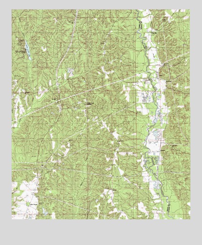
Jones, AL USGS Topographic Map
Click on map above to begin viewing in our Map Viewer.

This topographic map contains these locations and features:
Feature Name Type Latitude Longitude GNIS ID View Map
Barnes CemeteryCemeteryN32.5698°W86.9522°1805695View Map
Bethel School (historical)SchoolN32.5699°W86.9519°144522View Map
Camp GristLocaleN32.6051°W86.9939°115461View Map
Cedar Grove ChurchChurchN32.6174°W86.9567°115787View Map
Elyton ChurchChurchN32.6051°W86.9347°117971View Map
Elyton School (historical)SchoolN32.6054°W86.9347°144559View Map
F W Lawrence DamDamN32.5018°W86.9767°130635View Map
FremontPopulated PlaceN32.5454°W86.8947°151779View Map
Grove Hill ChurchChurchN32.5710°W86.9692°119446View Map
JonesPopulated PlaceN32.5840°W86.8975°151908View Map
Jones CemeteryCemeteryN32.5913°W86.8881°147580View Map
Jones ChurchChurchN32.5912°W86.8958°147581View Map
Jones Post OfficePost OfficeN32.5873°W86.8976°167084View Map
Jones Volunteer Fire DepartmentBuildingN32.5831°W86.8934°2691259View Map
Lawrence LakeReservoirN32.5036°W86.9767°130634View Map
Martin CreekStreamN32.5557°W86.9967°160043View Map
Mount Pleasant CemeteryCemeteryN32.5762°W86.9908°1805701View Map
Mount Pleasant ChurchChurchN32.5751°W86.9919°123366View Map
Paul M Grist State ParkParkN32.5982°W86.9908°160784View Map
Pea Ridge CemeteryCemeteryN32.5176°W86.9303°1805703View Map
Pea Ridge ChurchChurchN32.5174°W86.9328°124528View Map
Pea Ridge SchoolSchoolN32.5254°W86.9297°124529View Map
Pleasant Grove ChurchChurchN32.5462°W86.9267°124955View Map
Pleasant Valley ChurchChurchN32.5826°W86.8919°147615View Map
Pleasant Valley ChurchChurchN32.5918°W86.8939°125046View Map
Rex Waldrop DamDamN32.5918°W86.9600°130743View Map
Rex Waldrop LakeReservoirN32.5918°W86.9600°130744View Map
Saint James ChurchChurchN32.5465°W86.9605°126105View Map
Spring Hill ChurchChurchN32.5429°W86.8875°127256View Map
Valley Creek JunctionPopulated PlaceN32.5685°W86.9489°153828View Map
Valley Creek LakeReservoirN32.6012°W86.9886°153829View Map
Valley Creek Park Lake DamDamN32.5935°W86.9867°130746View Map
Valley GrandePopulated PlaceN32.5090°W86.9875°155519View Map
Valley Grande Volunteer Fire Department Station 1BuildingN32.5235°W86.9823°2691361View Map
Vine HillPopulated PlaceN32.6124°W86.9022°153853View Map
Vine Hill ChurchChurchN32.6185°W86.8914°128460View Map
Vine Hill Station (historical)LocaleN32.6126°W86.9039°163292View Map
Welch CemeteryCemeteryN32.6093°W86.9322°154751View Map

Note: Coordinates in the location and feature list above are referenced to NAD83 datum.


Copyright (C) 2008-2024 Ryan Niemi / Sunset Dynamics ... All Rights Reserved