TopoQuest Logo
Do you find TopoQuest useful?
Help keep TopoQuest running and adding new maps/features by donating!
Bitcoin:  19c7KJd3qBynnjoSw5npx9KScwjBe4ifkT
Litecoin:  LXs6TkuXGGXo1vDsWCkWVdjQX94eUKd6ui
Home View Maps Find Maps Find Places Resources & Links


Platteville, Colorado Topographic Map

USGS Map Title: Platteville, CO
USGS Map MRC: 40104B7
DRG (GeoTIFF) Download: o40104b7.tif


Neighboring USGS Topographic Map Quads:


  Johnstown, CO  
40104C8
 

  Milliken, CO  
40104C7
 

  La Salle, CO  
40104C6
 

  Gowanda, CO  
40104B8
 

  Platteville, CO  
40104B7
 

  Milton Reservoir, CO  
40104B6
 

  Frederick, CO  
40104A8
 

  Fort Lupton, CO  
40104A7
 

  Hudson, CO  
40104A6


Map MRC Location:

N41°
W105°
N41°
W104°
H8 H7 H6 H5 H4 H3 H2 H1
G8 G7 G6 G5 G4 G3 G2 G1
F8 F7 F6 F5 F4 F3 F2 F1
E8 E7 E6 E5 E4 E3 E2 E1
D8 D7 D6 D5 D4 D3 D2 D1
C8 C7 C6 C5 C4 C3 C2 C1
B8 B7 B6 B5 B4 B3 B2 B1
A8 A7 A6 A5 A4 A3 A2 A1
N40°
W105°
N40°
W104°

Platteville, CO USGS 1:24K Topographic Map Preview:
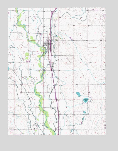
Platteville, CO USGS Topographic Map
Click on map above to begin viewing in our Map Viewer.

This topographic map contains these locations and features:
Feature Name Type Latitude Longitude GNIS ID View Map
Beeman DitchCanalN40.2028°W104.8583°202755View Map
Bella Holstein DairyLocaleN40.2136°W104.8053°2707022View Map
Bucker DitchCanalN40.2083°W104.8255°180795View Map
Fulton Extension DitchCanalN40.1583°W104.7702°180796View Map
Fulton Waste DamDamN40.1583°W104.7789°201350View Map
Fulton Waste ReservoirReservoirN40.1583°W104.7789°201351View Map
IoneLocaleN40.1489°W104.8108°180792View Map
Lupton Bottom DitchCanalN40.1500°W104.8533°202754View Map
MadduxLocaleN40.1922°W104.8197°180787View Map
Meadow Island Ditch Number 2CanalN40.1889°W104.8475°180798View Map
Medow Island Ditch Number 1CanalN40.1780°W104.8589°169497View Map
Mizpah CemeteryCemeteryN40.2181°W104.8138°180789View Map
MooreLocaleN40.1894°W104.8472°180791View Map
Morning Fresh FarmsLocaleN40.2222°W104.7664°2680775View Map
Mose Davis LakeReservoirN40.1594°W104.7759°180794View Map
Mose Davis Number 2 DamDamN40.1670°W104.7862°201504View Map
Mose Davis Reservoir Number 2ReservoirN40.1652°W104.7852°201505View Map
Old Fort Vasquez (historical)Populated PlaceN40.1944°W104.8211°180786View Map
PlattevillePopulated PlaceN40.2150°W104.8227°180790View Map
Platteville - Gilcrest Fire Protection District Platteville StationBuildingN40.2181°W104.8229°2666861View Map
Platteville DitchCanalN40.1889°W104.8169°202756View Map
Platteville Post OfficePost OfficeN40.2151°W104.8234°2736028View Map
Platteville Town Police DepartmentBuildingN40.2178°W104.8237°2757254View Map
Reck AirstripAirportN40.1672°W104.7952°2443935View Map
Saint Francis CemeteryCemeteryN40.1457°W104.8669°180793View Map
Spear CanalCanalN40.2083°W104.7875°180797View Map
Town of PlattevilleCivilN40.2252°W104.8532°2412489View Map
Twombley DamDamN40.1483°W104.7782°200224View Map
Twombly ReservoirReservoirN40.1477°W104.7776°200225View Map
VollmarPopulated PlaceN40.1350°W104.8389°180788View Map

Note: Coordinates in the location and feature list above are referenced to NAD83 datum.


Copyright (C) 2008-2024 Ryan Niemi / Sunset Dynamics ... All Rights Reserved