TopoQuest Logo
Do you find TopoQuest useful?
Help keep TopoQuest running and adding new maps/features by donating!
Bitcoin:  19c7KJd3qBynnjoSw5npx9KScwjBe4ifkT
Litecoin:  LXs6TkuXGGXo1vDsWCkWVdjQX94eUKd6ui
Home View Maps Find Maps Find Places Resources & Links


Westover, North Carolina Topographic Map

USGS Map Title: Westover, NC
USGS Map MRC: 35076H6
DRG (GeoTIFF) Download: o35076h6.tif


Neighboring USGS Topographic Map Quads:


  Merry Hill, NC  
36076A7
 

  Edenhouse, NC  
36076A6
 

  Edenton, NC  
36076A5
 

  Woodard, NC  
35076H7
 

  Westover, NC  
35076H6
 

  Roper North, NC  
35076H5
 

  Plymouth West, NC  
35076G7
 

  Plymouth East, NC  
35076G6
 

  Roper South, NC  
35076G5


Map MRC Location:

N36°
W77°
N36°
W76°
H8 H7 H6 H5 H4 H3 H2 H1
G8 G7 G6 G5 G4 G3 G2 G1
F8 F7 F6 F5 F4 F3 F2 F1
E8 E7 E6 E5 E4 E3 E2 E1
D8 D7 D6 D5 D4 D3 D2 D1
C8 C7 C6 C5 C4 C3 C2 C1
B8 B7 B6 B5 B4 B3 B2 B1
A8 A7 A6 A5 A4 A3 A2 A1
N35°
W77°
N35°
W76°

Westover, NC USGS 1:24K Topographic Map Preview:
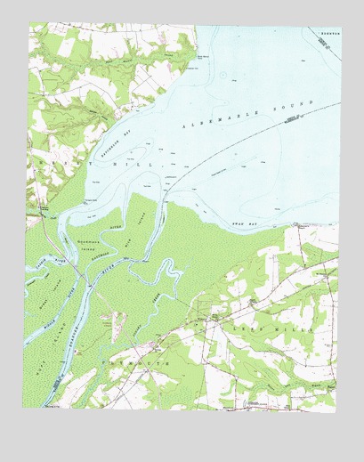
Westover, NC USGS Topographic Map
Click on map above to begin viewing in our Map Viewer.

This topographic map contains these locations and features:
Feature Name Type Latitude Longitude GNIS ID View Map
Albemarle BeachPopulated PlaceN35.9360°W76.6413°1018783View Map
Batchelor BayBayN35.9627°W76.7122°980612View Map
Black Walnut PointCapeN35.9927°W76.6827°981548View Map
Buncombe HallLocaleN35.8907°W76.6299°1003424View Map
Cashie RiverStreamN35.9396°W76.7274°1025223View Map
Cashoke CreekStreamN35.9379°W76.7363°982730View Map
Cashoke LandingLocaleN35.9399°W76.7441°1019554View Map
Conaby CreekStreamN35.9232°W76.7063°1019749View Map
Eastmost RiverStreamN35.9416°W76.7105°984562View Map
ElmwoodPopulated PlaceN35.9729°W76.7144°1004841View Map
Freemans LandingLocaleN35.9385°W76.7491°1006439View Map
Goodmans IslandIslandN35.9279°W76.7249°985804View Map
Great IslandCapeN35.9115°W76.7394°1025350View Map
Grennell CreekStreamN35.9210°W76.7416°986137View Map
Huff IslandIslandN35.8929°W76.7394°1025409View Map
Louse IslandIslandN35.9385°W76.6944°989044View Map
MacedoniaPopulated PlaceN35.8754°W76.6649°1021321View Map
Macedonia ChurchChurchN35.8754°W76.6649°1003435View Map
Middle RiverStreamN35.9329°W76.7344°989794View Map
Morgan SwampStreamN35.9671°W76.7155°990237View Map
Mount Delane ChurchChurchN35.9188°W76.6288°990372View Map
PetersonLocaleN35.9768°W76.7427°1006427View Map
Purchase IslandsIslandN35.9157°W76.7324°1003449View Map
Rice IslandIslandN35.9324°W76.7066°993283View Map
Riverside Airport (historical)AirportN35.9013°W76.7122°997993View Map
Roanoke RiverStreamN35.9424°W76.6949°1502110View Map
Saint Luke CemeteryCemeteryN35.8968°W76.6269°993982View Map
Saints Delight ChurchChurchN35.9110°W76.6602°994150View Map
Socona ChurchChurchN35.8952°W76.6980°995096View Map
Swain (historical)Populated PlaceN35.9166°W76.6280°1003454View Map
Swan BayBayN35.9360°W76.6619°995740View Map
Terrapin PointCapeN35.9429°W76.7266°995937View Map
Tidewater Experiment StationLocaleN35.8763°W76.6597°996101View Map
WestoverPopulated PlaceN35.9041°W76.6769°1023186View Map
White Marsh ChurchChurchN35.9043°W76.6727°997146View Map
Wood IslandIslandN35.9279°W76.7324°997567View Map
Zion ChapelChurchN35.8763°W76.6424°997752View Map

Note: Coordinates in the location and feature list above are referenced to NAD83 datum.


Copyright (C) 2008-2025 Ryan Niemi / Sunset Dynamics ... All Rights Reserved