TopoQuest Logo
Do you find TopoQuest useful?
Help keep TopoQuest running and adding new maps/features by donating!
Bitcoin:  19c7KJd3qBynnjoSw5npx9KScwjBe4ifkT
Litecoin:  LXs6TkuXGGXo1vDsWCkWVdjQX94eUKd6ui
Home View Maps Find Maps Find Places Resources & Links


Luxemburg, Wisconsin Topographic Map

USGS Map Title: Luxemburg, WI
USGS Map MRC: 44087E6
DRG (GeoTIFF) Download: o44087e6.tif


Neighboring USGS Topographic Map Quads:


  Dyckesville, WI  
44087F7
 

  Namur, WI  
44087F6
 

  Brussels, WI  
44087F5
 

  New Franken, WI  
44087E7
 

  Luxemburg, WI  
44087E6
 

  Casco, WI  
44087E5
 

  Poland, WI  
44087D7
 

  Stangelville, WI  
44087D6
 

  Kewaunee, WI  
44087D5


Map MRC Location:

N45°
W88°
N45°
W87°
H8 H7 H6 H5 H4 H3 H2 H1
G8 G7 G6 G5 G4 G3 G2 G1
F8 F7 F6 F5 F4 F3 F2 F1
E8 E7 E6 E5 E4 E3 E2 E1
D8 D7 D6 D5 D4 D3 D2 D1
C8 C7 C6 C5 C4 C3 C2 C1
B8 B7 B6 B5 B4 B3 B2 B1
A8 A7 A6 A5 A4 A3 A2 A1
N44°
W88°
N44°
W87°

Luxemburg, WI USGS 1:24K Topographic Map Preview:
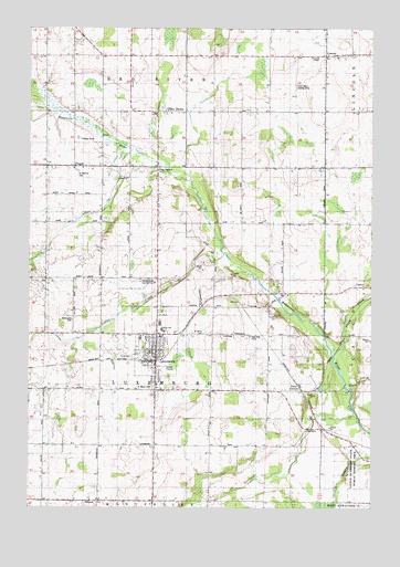
Luxemburg, WI USGS Topographic Map
Click on map above to begin viewing in our Map Viewer.

This topographic map contains these locations and features:
Feature Name Type Latitude Longitude GNIS ID View Map
Blue View Dairy FarmsLocaleN44.5442°W87.7192°2710603View Map
Casco CreekStreamN44.5397°W87.6390°1562763View Map
Casco JunctionPopulated PlaceN44.5306°W87.6506°1577538View Map
Frog StationLocaleN44.5889°W87.7034°1565352View Map
Funk AerodromeAirportN44.6126°W87.6534°1582055View Map
Garfield School (historical)SchoolN44.5747°W87.7443°1840635View Map
Grant School (historical)SchoolN44.5528°W87.6823°1840637View Map
Haen AcresLocaleN44.5150°W87.6778°2710602View Map
Hallet Dairy FarmLocaleN44.5842°W87.6253°2611841View Map
Hawthorne School (historical)SchoolN44.5200°W87.6629°1840639View Map
Holmes School (historical)SchoolN44.5164°W87.7240°1840643View Map
J - Mar Hillside AcresLocaleN44.5289°W87.6861°2710609View Map
Junion Homestead FarmLocaleN44.5875°W87.6697°2710489View Map
LincolnPopulated PlaceN44.6181°W87.6420°1568064View Map
Lincoln ChapelChurchN44.6175°W87.6473°1568071View Map
Little Scarboro State Public Fishery AreaParkN44.5106°W87.6295°1568409View Map
Lowell School (historical)SchoolN44.5886°W87.7137°1840656View Map
LuxemburgPopulated PlaceN44.5386°W87.7040°1568827View Map
Luxemburg - Casco High SchoolSchoolN44.5462°W87.7013°1840658View Map
Luxemburg - Casco Intermediate SchoolSchoolN44.5482°W87.7024°2716911View Map
Luxemburg - Casco Primary SchoolSchoolN44.5491°W87.6998°1840657View Map
Luxemburg CreekStreamN44.5636°W87.6768°1568828View Map
Luxemburg Emergency and Rescue ServicesBuildingN44.5382°W87.7053°2698290View Map
Luxemburg Fire DepartmentBuildingN44.5410°W87.7026°2697995View Map
Luxemburg Police DepartmentBuildingN44.5415°W87.7068°2759594View Map
Martinville School (historical)SchoolN44.6031°W87.7437°1840661View Map
McKinley School (historical)SchoolN44.5889°W87.6676°1840662View Map
Miesler FarmsLocaleN44.5469°W87.6847°2710610View Map
NeuernPopulated PlaceN44.5019°W87.7248°1570577View Map
North Brook Country ClubLocaleN44.5589°W87.7043°1581296View Map
Rogers CreekStreamN44.5328°W87.6343°1572532View Map
Saint John's Lutheran CemeteryCemeteryN44.5455°W87.6863°1573058View Map
Saint Johns Lutheran ChurchChurchN44.5428°W87.7045°1840680View Map
Saint Martin Catholic ChurchChurchN44.5883°W87.7340°1840690View Map
Saint Martins CemeteryCemeteryN44.5878°W87.7326°1573253View Map
Saint Mary Catholic ChurchChurchN44.5314°W87.7031°1840691View Map
Saint Mary SchoolSchoolN44.5322°W87.7034°1840693View Map
Saint Mary's CemeteryCemeteryN44.5312°W87.7048°1573298View Map
Saint Odile Catholic ChurchChurchN44.6028°W87.6987°1840694View Map
Saint Odiles Catholic CemeteryCemeteryN44.6028°W87.7001°1840695View Map
Saint Peter Catholic ChurchChurchN44.6175°W87.6379°1840699View Map
Saint Peters Catholic CemeteryCemeteryN44.6175°W87.6376°1840700View Map
Scarboro CreekStreamN44.5247°W87.6312°1573773View Map
School CreekStreamN44.5661°W87.6793°1573800View Map
Spiritualist CemeteryCemeteryN44.5492°W87.7340°1574564View Map
Theys OrchardLocaleN44.5317°W87.7003°2710617View Map
Thiry DaemsPopulated PlaceN44.6031°W87.6931°1575365View Map
TonetPopulated PlaceN44.5892°W87.7337°1575506View Map
Town of LuxemburgCivilN44.5452°W87.6730°1583611View Map
Village of LuxemburgCivilN44.5448°W87.7064°1583610View Map
Walhain School (historical)SchoolN44.5458°W87.7390°1840703View Map
Washington School (historical)SchoolN44.6078°W87.6934°1840704View Map

Note: Coordinates in the location and feature list above are referenced to NAD83 datum.


Copyright (C) 2008-2025 Ryan Niemi / Sunset Dynamics ... All Rights Reserved