TopoQuest Logo
Do you find TopoQuest useful?
Help keep TopoQuest running and adding new maps/features by donating!
Bitcoin:  19c7KJd3qBynnjoSw5npx9KScwjBe4ifkT
Litecoin:  LXs6TkuXGGXo1vDsWCkWVdjQX94eUKd6ui
Home View Maps Find Maps Find Places Resources & Links


Dark Canyon, Utah Topographic Map

USGS Map Title: Dark Canyon, UT
USGS Map MRC: 40110E1
DRG (GeoTIFF) Download: o40110e1.tif


Neighboring USGS Topographic Map Quads:


  Bollie Lake, UT  
40110F2
 

  Rasmussen Lakes, UT  
40110F1
 

  Paradise Park, UT  
40109F8
 

  Heller Lake, UT  
40110E2
 

  Dark Canyon, UT  
40110E1
 

  Ice Cave Peak, UT  
40109E8
 

  Neola NW, UT  
40110D2
 

  Neola, UT  
40110D1
 

  Whiterocks, UT  
40109D8


Map MRC Location:

N41°
W111°
N41°
W110°
H8 H7 H6 H5 H4 H3 H2 H1
G8 G7 G6 G5 G4 G3 G2 G1
F8 F7 F6 F5 F4 F3 F2 F1
E8 E7 E6 E5 E4 E3 E2 E1
D8 D7 D6 D5 D4 D3 D2 D1
C8 C7 C6 C5 C4 C3 C2 C1
B8 B7 B6 B5 B4 B3 B2 B1
A8 A7 A6 A5 A4 A3 A2 A1
N40°
W111°
N40°
W110°

Dark Canyon, UT USGS 1:24K Topographic Map Preview:
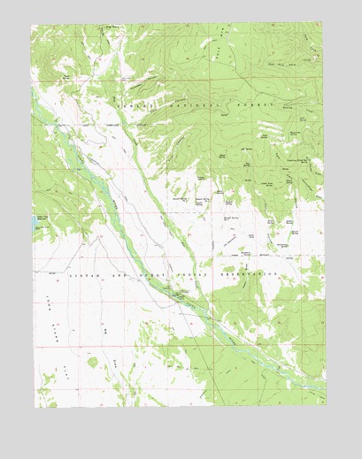
Dark Canyon, UT USGS Topographic Map
Click on map above to begin viewing in our Map Viewer.

This topographic map contains these locations and features:
Feature Name Type Latitude Longitude GNIS ID View Map
Ant ReservoirsReservoirN40.5518°W110.0439°1438235View Map
Beaver SpringSpringN40.5563°W110.0150°1438544View Map
Blank SpringSpringN40.5813°W110.0422°1438904View Map
Boundary SpringSpringN40.5492°W110.0322°1439037View Map
Buffalo SpringSpringN40.5662°W110.0433°1439257View Map
Bull Elk CreekStreamN40.6158°W110.0899°1439265View Map
Center Fork SpringSpringN40.5720°W110.0227°1439617View Map
Coyote SpringSpringN40.5667°W110.0557°1440124View Map
Dark CanyonValleyN40.5927°W110.0813°1440268View Map
East Cart HollowValleyN40.5497°W110.0163°1440774View Map
Elk SpringSpringN40.5836°W110.0365°1440911View Map
Fawn SpringSpringN40.5698°W110.0468°1441020View Map
First CanyonValleyN40.5741°W110.0763°1441048View Map
Grits SpringSpringN40.5930°W110.0114°1441507View Map
Hackamore SpringSpringN40.5521°W110.0165°1441539View Map
Harmston CanyonValleyN40.5980°W110.0865°1441607View Map
Henry SpringSpringN40.5728°W110.0139°1441712View Map
Lightning Killed Bull SpringSpringN40.5798°W110.0073°1442584View Map
Lower Vinta Canal BridgeBridgeN40.5925°W110.1135°1450191View Map
Mugwump SpringSpringN40.5885°W110.0157°1443724View Map
Nephi DrawValleyN40.5233°W110.0374°1443795View Map
Nephi PondReservoirN40.5543°W110.0307°1443797View Map
Pole CreekStreamN40.5300°W110.0513°1444540View Map
Pole Creek CanalCanalN40.5575°W110.0668°1444546View Map
Powerplant CanalCanalN40.5747°W110.0913°1444626View Map
Preece SpringSpringN40.5598°W110.0220°1444635View Map
Puppy SpringSpringN40.5744°W110.0549°1444677View Map
Ray SpringSpringN40.5781°W110.0323°1444748View Map
Rock SpringSpringN40.5876°W110.0246°1445099View Map
Russell Spring Number 1SpringN40.5673°W110.0590°1454510View Map
Russell Spring Number 2SpringN40.5667°W110.0498°1454511View Map
Russell Spring Number 3SpringN40.5610°W110.0439°1454512View Map
Saddle SpringSpringN40.5597°W110.0141°1445226View Map
Trail SpringSpringN40.6078°W110.1091°1446699View Map
Uinta Canyon Summer HomesLocaleN40.5936°W110.1035°1450190View Map
Uinta Canyon Summer HomesLocaleN40.5936°W110.1149°1454933View Map
Uinta River BridgeBridgeN40.5913°W110.1146°1450193View Map
Uintah Canyon Youth CampLocaleN40.5361°W110.0638°1446837View Map
Uintah PowerplantLocaleN40.5377°W110.0660°1454546View Map
Upper Uinta Canal BridgeBridgeN40.5972°W110.1160°1450192View Map
West Fork Farm CreekStreamN40.6141°W110.0002°1447143View Map
Zeagher CabinLocaleN40.6083°W110.0871°1450189View Map
Zeagher CabinLocaleN40.6158°W110.0896°1454959View Map

Note: Coordinates in the location and feature list above are referenced to NAD83 datum.


Copyright (C) 2008-2025 Ryan Niemi / Sunset Dynamics ... All Rights Reserved