TopoQuest Logo
Do you find TopoQuest useful?
Help keep TopoQuest running and adding new maps/features by donating!
Bitcoin:  19c7KJd3qBynnjoSw5npx9KScwjBe4ifkT
Litecoin:  LXs6TkuXGGXo1vDsWCkWVdjQX94eUKd6ui
Home View Maps Find Maps Find Places Resources & Links


Pond Run, Ohio Topographic Map

USGS Map Title: Pond Run, OH
USGS Map MRC: 38083F2
DRG (GeoTIFF) Download: o38083f2.tif


Neighboring USGS Topographic Map Quads:


  Blue Creek, OH  
38083G3
 

  Otway, OH  
38083G2
 

  West Portsmouth, OH  
38083G1
 

  Buena Vista, OH  
38083F3
 

  Pond Run, OH  
38083F2
 

  Friendship, OH  
38083F1
 

  Vanceburg, KY  
38083E3
 

  Garrison, KY  
38083E2
 

  Brushart, KY  
38083E1


Map MRC Location:

N39°
W84°
N39°
W83°
H8 H7 H6 H5 H4 H3 H2 H1
G8 G7 G6 G5 G4 G3 G2 G1
F8 F7 F6 F5 F4 F3 F2 F1
E8 E7 E6 E5 E4 E3 E2 E1
D8 D7 D6 D5 D4 D3 D2 D1
C8 C7 C6 C5 C4 C3 C2 C1
B8 B7 B6 B5 B4 B3 B2 B1
A8 A7 A6 A5 A4 A3 A2 A1
N38°
W84°
N38°
W83°

Pond Run, OH USGS 1:24K Topographic Map Preview:
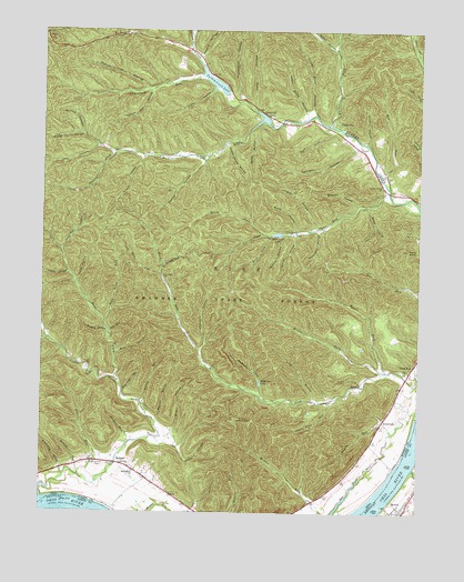
Pond Run, OH USGS Topographic Map
Click on map above to begin viewing in our Map Viewer.

This topographic map contains these locations and features:
Feature Name Type Latitude Longitude GNIS ID View Map
Bald Knob RunStreamN38.6751°W83.2288°1037591View Map
Barbara RunStreamN38.7209°W83.1435°1049386View Map
Blue Clay HollowValleyN38.6659°W83.2246°1038136View Map
Boland RunStreamN38.6345°W83.2371°1038179View Map
Bond HollowValleyN38.7042°W83.1416°1038187View Map
Broad HollowValleyN38.6970°W83.1657°1038329View Map
Brown HollowValleyN38.6465°W83.2060°1070695View Map
Brush ForkStreamN38.6976°W83.1763°1038415View Map
Brushy ForkStreamN38.6892°W83.2099°1038429View Map
Buck LickStreamN38.7242°W83.1510°1060902View Map
Camp OyoPopulated PlaceN38.7259°W83.1524°1048576View Map
Conklin HollowValleyN38.7217°W83.1427°1039309View Map
Coriell School (historical)SchoolN38.7454°W83.2010°1049388View Map
Cotton Eye HollowValleyN38.7342°W83.2141°1039389View Map
Cutlipp HollowValleyN38.7195°W83.1463°1039552View Map
Dead Man HollowValleyN38.6934°W83.2432°1039629View Map
Dodds HollowValleyN38.6420°W83.2049°1039727View Map
Dry RunStreamN38.6351°W83.2368°1039797View Map
East Fork Pond RunStreamN38.6617°W83.1352°1039987View Map
East Fork Upper Twin CreekStreamN38.6598°W83.2252°1039989View Map
Elmtree School (historical)SchoolN38.6331°W83.2130°1049390View Map
Evans HollowValleyN38.7167°W83.2168°1040259View Map
Formans BottomFlatN38.6317°W83.1286°2362987View Map
Gabe RunStreamN38.6867°W83.2105°1040738View Map
Givens LandingLocaleN38.6256°W83.2263°1049391View Map
Grass Lick RunStreamN38.6540°W83.1541°1041058View Map
Groundhog HollowValleyN38.6367°W83.2438°1041194View Map
Harber Fork Turkey CreekStreamN38.7259°W83.1541°1037283View Map
Hobey HollowValleyN38.7459°W83.1543°1041635View Map
Hog Thief HollowValleyN38.6567°W83.2227°1041654View Map
Hogpen HollowValleyN38.6995°W83.1591°1041657View Map
Hoosier HollowValleyN38.7437°W83.1971°1041751View Map
Jake RunStreamN38.6717°W83.2277°1042047View Map
KennvalePopulated PlaceN38.6487°W83.1366°1042227View Map
Lampblack RunStreamN38.7387°W83.1974°1042406View Map
Leatherwood School (historical)SchoolN38.6340°W83.1499°1049385View Map
Long HollowValleyN38.6551°W83.1588°1042739View Map
Long HollowValleyN38.7195°W83.2321°1042741View Map
Long HollowValleyN38.7309°W83.1799°1042742View Map
Lower Shaw HollowValleyN38.7301°W83.1610°1066375View Map
Mackletree MissionChurchN38.7176°W83.1952°1042869View Map
Mackletree TreeStreamN38.7273°W83.1768°1066376View Map
Massey HollowValleyN38.6498°W83.2110°1043053View Map
McBride LakeReservoirN38.6586°W83.1771°1043146View Map
McBride RunStreamN38.6554°W83.1766°1043147View Map
McDermitt CemeteryCemeteryN38.6373°W83.2293°1043162View Map
McGawPopulated PlaceN38.6379°W83.2246°1048963View Map
McGaw Post Office (historical)Post OfficeN38.6376°W83.2249°2044046View Map
McKendree CemeteryCemeteryN38.6362°W83.2188°1964261View Map
McKendree ChurchChurchN38.6356°W83.2188°1043175View Map
Middle Fork Pond RunStreamN38.6615°W83.1355°1043275View Map
Middle HollowValleyN38.6851°W83.1713°1066377View Map
Mudlick HollowValleyN38.6715°W83.2285°1043723View Map
Mundy RunStreamN38.6462°W83.1332°1043731View Map
Old Lade RunStreamN38.7454°W83.2007°1044090View Map
Pheasant HollowValleyN38.6673°W83.1971°1066380View Map
Picnic PointSummitN38.6931°W83.1288°1066381View Map
Plummer ForkStreamN38.7179°W83.2263°1044652View Map
Pond Lick LakeReservoirN38.6973°W83.1719°1044675View Map
Pond Lick RunStreamN38.7081°W83.1355°1044676View Map
Pond RunPopulated PlaceN38.6637°W83.1266°1057934View Map
Pond Run ChurchChurchN38.6859°W83.2093°1044677View Map
Pond Run Lookout TowerTowerN38.6492°W83.1849°1080168View Map
Pondrun Post Office (historical)Post OfficeN38.6640°W83.1263°2043974View Map
Poplar HollowValleyN38.7154°W83.1968°1044692View Map
Poplar Tree HollowValleyN38.7356°W83.2160°1044699View Map
Quitoff HollowValleyN38.7237°W83.2368°1044833View Map
Rock LickStreamN38.6965°W83.1738°1045113View Map
Rock LickStreamN38.7479°W83.2099°1065243View Map
Rock Lick HollowValleyN38.7462°W83.1527°1045114View Map
Rocky HollowValleyN38.7234°W83.1802°1045140View Map
Roosevelt LakeReservoirN38.7273°W83.1771°1078119View Map
Roosevelt Lake DamDamN38.7267°W83.1749°1078118View Map
Sawmill HollowValleyN38.7051°W83.1457°1045983View Map
Shady HollowValleyN38.6984°W83.1655°1046111View Map
Shawnee State ForestParkN38.7209°W83.2138°1074930View Map
Shawnee State Lodge HeliportAirportN38.7426°W83.2030°1082972View Map
Shawnee State ParkParkN38.7348°W83.1982°1058205View Map
Sheep House HollowValleyN38.7198°W83.1885°1046167View Map
Sheep Lot HollowValleyN38.7229°W83.2371°1046168View Map
Slate HollowValleyN38.7345°W83.1930°1046333View Map
Stable GutGutN38.6537°W83.2168°1046614View Map
Swanigen HollowValleyN38.6979°W83.1580°1046896View Map
Tarkiln HollowValleyN38.6870°W83.2413°1046955View Map
Township of NileCivilN38.6957°W83.1832°1086931View Map
Tucker RunStreamN38.6429°W83.2205°1047183View Map
Turkey Creek ChurchChurchN38.7095°W83.1371°1047195View Map
Turkey Creek LakeReservoirN38.7365°W83.1932°1078742View Map
Turkey Creek Lake DamDamN38.7334°W83.1899°1078741View Map
Union School (historical)SchoolN38.7270°W83.1713°1049387View Map
Upper Shaw HollowValleyN38.7292°W83.1627°1047375View Map
Upper Twin CreekStreamN38.6287°W83.2493°1047376View Map
Upper Twin Creek School (historical)SchoolN38.6595°W83.2246°1049389View Map
Vance CreekStreamN38.6365°W83.1263°505968View Map
Webb HollowValleyN38.6851°W83.2377°1070984View Map
Wes RunStreamN38.7095°W83.1352°1047683View Map
Williamson HollowValleyN38.7326°W83.1846°1047940View Map
Wolfden RunStreamN38.7495°W83.2210°1048053View Map
Wyckoffs LandingLocaleN38.6273°W83.2310°1061818View Map

Note: Coordinates in the location and feature list above are referenced to NAD83 datum.


Copyright (C) 2008-2024 Ryan Niemi / Sunset Dynamics ... All Rights Reserved