TopoQuest Logo
Do you find TopoQuest useful?
Help keep TopoQuest running and adding new maps/features by donating!
Bitcoin:  19c7KJd3qBynnjoSw5npx9KScwjBe4ifkT
Litecoin:  LXs6TkuXGGXo1vDsWCkWVdjQX94eUKd6ui
Home View Maps Find Maps Find Places Resources & Links


Garrison, Kentucky Topographic Map

USGS Map Title: Garrison, KY
USGS Map MRC: 38083E2
DRG (GeoTIFF) Download: o38083e2.tif


Neighboring USGS Topographic Map Quads:


  Buena Vista, OH  
38083F3
 

  Pond Run, OH  
38083F2
 

  Friendship, OH  
38083F1
 

  Vanceburg, KY  
38083E3
 

  Garrison, KY  
38083E2
 

  Brushart, KY  
38083E1
 

  Head of Grassy, KY  
38083D3
 

  Wesleyville, KY  
38083D2
 

  Tygarts Valley, KY  
38083D1


Map MRC Location:

N39°
W84°
N39°
W83°
H8 H7 H6 H5 H4 H3 H2 H1
G8 G7 G6 G5 G4 G3 G2 G1
F8 F7 F6 F5 F4 F3 F2 F1
E8 E7 E6 E5 E4 E3 E2 E1
D8 D7 D6 D5 D4 D3 D2 D1
C8 C7 C6 C5 C4 C3 C2 C1
B8 B7 B6 B5 B4 B3 B2 B1
A8 A7 A6 A5 A4 A3 A2 A1
N38°
W84°
N38°
W83°

Garrison, KY USGS 1:24K Topographic Map Preview:
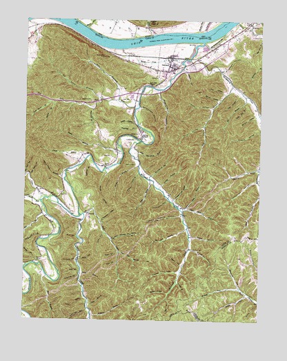
Garrison, KY USGS Topographic Map
Click on map above to begin viewing in our Map Viewer.

This topographic map contains these locations and features:
Feature Name Type Latitude Longitude GNIS ID View Map
Alum HollowValleyN38.5347°W83.2221°485909View Map
Anderson BranchStreamN38.5648°W83.2127°485933View Map
Armstrong ChurchChurchN38.5252°W83.2424°2362955View Map
Armstrong SchoolSchoolN38.5248°W83.2427°486039View Map
Bear BranchStreamN38.5181°W83.2377°486544View Map
Bear HollowValleyN38.5573°W83.1832°486571View Map
Beckett Railroad Station (historical)LocaleN38.5339°W83.2213°2362960View Map
Beechy HollowValleyN38.5201°W83.1678°486760View Map
Bevins ChapelChurchN38.5765°W83.1871°487064View Map
Bevins CreekStreamN38.6131°W83.1985°487065View Map
Big Lick BranchStreamN38.5387°W83.1630°487213View Map
Big Stave HollowValleyN38.5605°W83.2486°487277View Map
Bill Chain BranchStreamN38.5981°W83.1393°487301View Map
Board Tree HollowValleyN38.5045°W83.2157°487579View Map
Bridge BranchStreamN38.5231°W83.2438°487888View Map
Briery BranchStreamN38.6240°W83.1388°487905View Map
Brightman CemeteryCemeteryN38.5917°W83.2146°487912View Map
Brown HollowValleyN38.5285°W83.1999°488007View Map
Bruce Family GraveyardCemeteryN38.5895°W83.1924°2362963View Map
Bruce HollowValleyN38.5234°W83.1662°488053View Map
Bruce Railroad Station (historical)LocaleN38.5895°W83.1917°2362964View Map
Buris HollowValleyN38.6044°W83.1656°488426View Map
Cherry Tree HollowValleyN38.5009°W83.2151°489415View Map
Christy CemeteryCemeteryN38.5776°W83.1888°489504View Map
Clarks BranchStreamN38.5670°W83.2177°489549View Map
Clay BranchStreamN38.5092°W83.1732°489567View Map
Cloverleaf BranchStreamN38.5815°W83.1896°489707View Map
Cow HollowValleyN38.5358°W83.2070°490192View Map
Dry HollowValleyN38.5952°W83.2003°491223View Map
Elliots LandingLocaleN38.6167°W83.2013°1049536View Map
First HollowValleyN38.5947°W83.1443°492099View Map
Flatwoods BranchStreamN38.5876°W83.2138°492226View Map
Garden BranchStreamN38.5642°W83.1891°492691View Map
GarrisonPopulated PlaceN38.6062°W83.1732°492728View Map
Garrison Census Designated PlaceCensusN38.6075°W83.1833°2629620View Map
Garrison DivisionCivilN38.5765°W83.1669°1937017View Map
Garrison Landing (historical)LocaleN38.6159°W83.1699°2362991View Map
Garrison Post OfficePost OfficeN38.6059°W83.1722°2362992View Map
Garrison Railroad Station (historical)LocaleN38.6095°W83.1736°2362993View Map
Garrison School (historical)SchoolN38.6035°W83.1720°2362994View Map
Garrison Volunteer Fire DepartmentBuildingN38.6045°W83.1710°2636692View Map
Graveyard HollowValleyN38.5297°W83.1606°493186View Map
Greenbrier HollowValleyN38.5960°W83.1791°493319View Map
Gum HollowValleyN38.5211°W83.2203°493483View Map
House HollowValleyN38.5092°W83.2178°494639View Map
Howland CemeteryCemeteryN38.6192°W83.1291°494694View Map
Hubbard BranchStreamN38.5020°W83.2138°494699View Map
Hubbard CemeteryCemeteryN38.5753°W83.1910°494704View Map
Iller BranchStreamN38.5937°W83.1330°494885View Map
John A Lewis BranchStreamN38.5606°W83.2285°495314View Map
John Howard HollowValleyN38.5339°W83.2035°495328View Map
Kinniconick CreekStreamN38.6165°W83.1552°513155View Map
Kinnicunick Post Office (historical)Post OfficeN38.6159°W83.1566°2363014View Map
Kinny Mills Post Office (historical)Post OfficeN38.5214°W83.2107°2363015View Map
Knott HollowValleyN38.5239°W83.2002°495853View Map
Leatherbelly BranchStreamN38.5334°W83.2393°496116View Map
Lick BranchStreamN38.5945°W83.1343°496446View Map
Little Bill Chain BranchStreamN38.5717°W83.1932°496626View Map
Little Iller BranchStreamN38.5937°W83.1330°496764View Map
Little Stave HollowValleyN38.5599°W83.2473°496869View Map
Lloyd Railroad Station (historical)LocaleN38.6096°W83.1576°2363018View Map
Lost HillSummitN38.5915°W83.1955°497192View Map
Low Gap BranchStreamN38.5279°W83.1988°497236View Map
Lower Twin BranchStreamN38.5470°W83.1674°497305View Map
Madden ForkStreamN38.5106°W83.1296°497432View Map
Matty CemeteryCemeteryN38.5526°W83.2288°497686View Map
Maynard HollowValleyN38.5142°W83.1349°497736View Map
McAtee LandingLocaleN38.6201°W83.1610°1049534View Map
McAtee RunStreamN38.6201°W83.1588°1076355View Map
McCormack LandingLocaleN38.6179°W83.1893°1049535View Map
McDowell CreekStreamN38.5745°W83.1882°497844View Map
McGinnis CemeteryCemeteryN38.5298°W83.1599°497865View Map
McGlone ForkStreamN38.5131°W83.1343°497868View Map
McKinney BranchStreamN38.5215°W83.2496°497909View Map
McKinnies Post Office (historical)Post OfficeN38.5523°W83.2461°2363025View Map
Mill BranchStreamN38.5476°W83.2399°498228View Map
Mill Hollow CreekStreamN38.6239°W83.2492°2363027View Map
Miller HollowValleyN38.5257°W83.2199°498345View Map
Montgomery CreekStreamN38.6087°W83.1621°498512View Map
Moore HollowValleyN38.5611°W83.2065°498556View Map
Moore RunStreamN38.6220°W83.2177°1076428View Map
Morrisons LandingLocaleN38.6201°W83.2141°1049537View Map
Murphys Landing (historical)LocaleN38.6218°W83.2277°2363031View Map
Murphys Landing (historical)LocaleN38.6154°W83.1793°2363032View Map
Negro HollowValleyN38.5349°W83.1603°499243View Map
Newberry HollowValleyN38.5602°W83.1822°499418View Map
Old House HollowValleyN38.5247°W83.2221°499844View Map
Old Kinniconick BedStreamN38.6201°W83.1441°499848View Map
Old Pond RunStreamN38.6206°W83.1538°1076563View Map
Old Trace BranchStreamN38.5926°W83.2102°499891View Map
Orchid BranchStreamN38.5551°W83.1782°499991View Map
Peach Orchard HollowValleyN38.5439°W83.1668°500321View Map
Pheasant Lick HollowValleyN38.5504°W83.1700°500511View Map
Pugh BranchStreamN38.5070°W83.2155°501420View Map
QuincyPopulated PlaceN38.6240°W83.1307°501486View Map
Quincy Railroad Station (historical)LocaleN38.6159°W83.1566°2363048View Map
Records Post Office (historical)Post OfficeN38.5646°W83.2070°2363050View Map
Red Brush SchoolSchoolN38.5720°W83.1999°501642View Map
Red Bush School (historical)SchoolN38.5707°W83.2006°2363051View Map
Rock Blind BranchStreamN38.5906°W83.2360°502101View Map
Rock Hill ChapelChurchN38.5981°W83.1827°502117View Map
Rock RunStreamN38.5495°W83.2416°502144View Map
Rockport Post Office (historical)Post OfficeN38.6173°W83.2180°2363059View Map
Round TopSummitN38.6098°W83.2099°502414View Map
Ruckel HollowValleyN38.5810°W83.1552°502451View Map
Scotts BranchStreamN38.5195°W83.2199°503108View Map
Second HollowValleyN38.5920°W83.1475°503149View Map
Shanty BranchStreamN38.5906°W83.2346°503247View Map
Sherman HollowValleyN38.5418°W83.2092°503359View Map
Shingle BranchStreamN38.5156°W83.1682°503389View Map
Skidmore CemeteryCemeteryN38.5648°W83.1910°503604View Map
Slate HollowValleyN38.5615°W83.1891°503649View Map
Slate HollowValleyN38.5727°W83.2109°503650View Map
Smoothrock HollowValleyN38.5888°W83.1893°503827View Map
Soapstone HollowValleyN38.5186°W83.2203°503864View Map
Spencer RunStreamN38.6192°W83.1802°1076943View Map
Spring BranchStreamN38.5112°W83.1721°504116View Map
Spy RunStreamN38.5895°W83.1893°504197View Map
Spy Run SchoolSchoolN38.5915°W83.2016°504198View Map
Stable HollowValleyN38.5824°W83.1922°504212View Map
Stamper HollowValleyN38.5853°W83.1273°504246View Map
Stockholm HollowValleyN38.6040°W83.1463°504440View Map
Sullivan CemeteryCemeteryN38.5640°W83.2066°504721View Map
Sullivan Railroad Stop (historical)LocaleN38.5658°W83.2024°2363076View Map
TanneryPopulated PlaceN38.5440°W83.2157°509185View Map
Tannery Church of ChristChurchN38.5519°W83.2350°2363080View Map
Tannery Post Office (historical)Post OfficeN38.5443°W83.2165°2363082View Map
Tannery SchoolSchoolN38.5517°W83.2349°504942View Map
Tar Camp HollowValleyN38.5586°W83.1263°504952View Map
Third HollowValleyN38.5885°W83.1509°505150View Map
Thompson HollowValleyN38.5503°W83.1734°505212View Map
Tomblesons RunStreamN38.6130°W83.2035°2364888View Map
Town BranchStreamN38.5507°W83.2386°505387View Map
Trace CreekStreamN38.5442°W83.2205°505424View Map
Upper Bruce (historical)Populated PlaceN38.5769°W83.1877°2363091View Map
Upper Bruce Post Office (historical)Post OfficeN38.5712°W83.2011°2363092View Map
Upper Twin BranchStreamN38.5456°W83.1655°505912View Map
Vilidan Landing (historical)LocaleN38.6138°W83.1926°2363095View Map
Waring CemeteryCemeteryN38.6006°W83.1780°506228View Map
Willis CemeteryCemeteryN38.5687°W83.2038°506847View Map
Willow Island (historical)IslandN38.6218°W83.1448°2363102View Map
Wolf CreekStreamN38.5440°W83.2202°506996View Map
Wright Railroad Station (historical)LocaleN38.5258°W83.2237°2363105View Map

Note: Coordinates in the location and feature list above are referenced to NAD83 datum.


Copyright (C) 2008-2025 Ryan Niemi / Sunset Dynamics ... All Rights Reserved