TopoQuest Logo
Do you find TopoQuest useful?
Help keep TopoQuest running and adding new maps/features by donating!
Bitcoin:  19c7KJd3qBynnjoSw5npx9KScwjBe4ifkT
Litecoin:  LXs6TkuXGGXo1vDsWCkWVdjQX94eUKd6ui
Home View Maps Find Maps Find Places Resources & Links


Vanceburg, Kentucky Topographic Map

USGS Map Title: Vanceburg, KY
USGS Map MRC: 38083E3
DRG (GeoTIFF) Download: o38083e3.tif


Neighboring USGS Topographic Map Quads:


  Concord, KY  
38083F4
 

  Buena Vista, OH  
38083F3
 

  Pond Run, OH  
38083F2
 

  Charters, KY  
38083E4
 

  Vanceburg, KY  
38083E3
 

  Garrison, KY  
38083E2
 

  Stricklett, KY  
38083D4
 

  Head of Grassy, KY  
38083D3
 

  Wesleyville, KY  
38083D2


Map MRC Location:

N39°
W84°
N39°
W83°
H8 H7 H6 H5 H4 H3 H2 H1
G8 G7 G6 G5 G4 G3 G2 G1
F8 F7 F6 F5 F4 F3 F2 F1
E8 E7 E6 E5 E4 E3 E2 E1
D8 D7 D6 D5 D4 D3 D2 D1
C8 C7 C6 C5 C4 C3 C2 C1
B8 B7 B6 B5 B4 B3 B2 B1
A8 A7 A6 A5 A4 A3 A2 A1
N38°
W84°
N38°
W83°

Vanceburg, KY USGS 1:24K Topographic Map Preview:
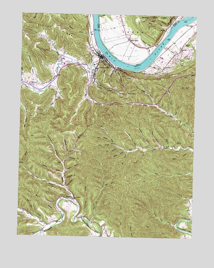
Vanceburg, KY USGS Topographic Map
Click on map above to begin viewing in our Map Viewer.

This topographic map contains these locations and features:
Feature Name Type Latitude Longitude GNIS ID View Map
Adams CemeteryCemeteryN38.5415°W83.3443°485770View Map
Alum Rock RidgeRidgeN38.5904°W83.3157°485913View Map
Appletree BranchStreamN38.5795°W83.3280°486013View Map
Axehandle BranchStreamN38.5467°W83.3396°486163View Map
Backbone HollowValleyN38.5519°W83.2664°486185View Map
Black Oak ChurchChurchN38.6067°W83.2596°487381View Map
Black Oak Volunteer Fire DepartmentBuildingN38.5989°W83.2700°2636691View Map
Blue Spring BranchStreamN38.5854°W83.3732°487550View Map
Buck LickStreamN38.5487°W83.2846°488234View Map
Buena VistaPopulated PlaceN38.6045°W83.2596°517565View Map
Buena Vista Cabin Railroad Station (historical)LocaleN38.6057°W83.2708°2362965View Map
Buena Vista StationLocaleN38.6190°W83.2524°488298View Map
Cassidy HollowValleyN38.5011°W83.3561°489065View Map
Cat BranchStreamN38.5409°W83.3727°489082View Map
Chestnut BranchStreamN38.5367°W83.3416°489422View Map
City of VanceburgCivilN38.5938°W83.3212°2405638View Map
ClarksburgPopulated PlaceN38.5851°W83.3660°489556View Map
Clarksburg BranchStreamN38.5412°W83.3430°489557View Map
Clay LickStreamN38.5506°W83.2880°489578View Map
Coon BranchStreamN38.5506°W83.3038°490035View Map
Crumbs Landing (historical)LocaleN38.6077°W83.2728°2362978View Map
Dravo Railroad Station (historical)LocaleN38.6199°W83.3265°2362980View Map
Dry RunStreamN38.5942°W83.3269°491238View Map
Dyer BranchStreamN38.5490°W83.2963°491387View Map
Evans CemeteryCemeteryN38.5890°W83.2960°491833View Map
Evans ChapelChurchN38.5806°W83.2982°491834View Map
Ewings LandingLocaleN38.5992°W83.3113°1055840View Map
Finger Board HollowValleyN38.5750°W83.2789°492081View Map
First Import Route for Horses Historical MarkerParkN38.5977°W83.3246°2744490View Map
Fish Gut BranchStreamN38.5967°W83.2835°492104View Map
Fly BranchStreamN38.6012°W83.3460°492284View Map
Fly Branch SchoolSchoolN38.6015°W83.3441°492285View Map
Fuller BranchStreamN38.5281°W83.3416°492606View Map
Gander BranchStreamN38.5873°W83.3260°492669View Map
Gilpen RunStreamN38.6248°W83.3199°1080430View Map
Grassy BranchStreamN38.5184°W83.3444°493147View Map
Griffin HollowValleyN38.5704°W83.2673°493383View Map
Groundhog BranchStreamN38.5437°W83.3402°493425View Map
Gunnel BranchStreamN38.5520°W83.2730°517315View Map
Hamilton BranchStreamN38.5084°W83.3241°493615View Map
Hazel BranchStreamN38.5876°W83.3519°493945View Map
Holly BranchStreamN38.5051°W83.3507°494403View Map
Holly CemeteryCemeteryN38.5131°W83.3710°494405View Map
Holly Hill ChurchChurchN38.5081°W83.3471°494411View Map
Irish BottomFlatN38.6076°W83.3055°1063837View Map
Jesse Grants Tanyards Historical MarkerParkN38.5211°W83.3372°2744493View Map
Kennedys BottomFlatN38.6174°W83.3245°2363010View Map
KinniconickPopulated PlaceN38.5212°W83.3380°495779View Map
Kinniconick Post Office (historical)Post OfficeN38.5212°W83.3380°1926481View Map
Leatherwood BranchStreamN38.5104°W83.3285°496119View Map
Lewis County FairgroundsLocaleN38.5989°W83.3430°2364886View Map
Lewis County Historical MarkerParkN38.6008°W83.3164°2744491View Map
Lewis County InfirmaryHospitalN38.5954°W83.3441°496323View Map
Lewis County Sheriff's OfficeBuildingN38.6006°W83.3165°2767475View Map
Lewis County Volunteer Fire CompanyBuildingN38.5966°W83.3452°2637389View Map
Machine BranchStreamN38.6156°W83.3232°497424View Map
Matthews BranchStreamN38.5498°W83.2799°497681View Map
McCall CemeteryCemeteryN38.6081°W83.2824°1083568View Map
McCall RunStreamN38.6029°W83.2830°1055878View Map
McCalls LandingLocaleN38.6017°W83.2843°1055879View Map
McKinleys LandingLocaleN38.6106°W83.3180°1055880View Map
Mill ForkStreamN38.5276°W83.3138°498280View Map
Miller BranchStreamN38.5145°W83.3435°498317View Map
Neds BranchStreamN38.5523°W83.3077°499216View Map
Nolan HollowValleyN38.5687°W83.2635°499507View Map
Ohio State ParkParkN38.6076°W83.2952°1083567View Map
Pigpen BranchStreamN38.5504°W83.2532°500614View Map
Powers LandingLocaleN38.6181°W83.3199°1055907View Map
Puncheon Camp HollowValleyN38.5070°W83.2624°501444View Map
Randville Post Office (historical)Post OfficeN38.5066°W83.3523°2363049View Map
Red Fox Landing (historical)LocaleN38.6157°W83.2649°2363052View Map
Reynolds ChapelChurchN38.6090°W83.2577°514896View Map
Rock RunStreamN38.6156°W83.2699°1080441View Map
Rock Run SchoolSchoolN38.5490°W83.2846°517313View Map
RockvillePopulated PlaceN38.6170°W83.2716°1061626View Map
Salt Lick CreekStreamN38.6073°W83.3205°502828View Map
Salt Lick Landing (historical)LocaleN38.6075°W83.3209°2363066View Map
Sand BranchStreamN38.6073°W83.2730°502895View Map
Sandy SpringsPopulated PlaceN38.6112°W83.2969°1080443View Map
Sandy Springs CemeteryCemeteryN38.6126°W83.2974°1731210View Map
Sandy Springs LandingLocaleN38.6048°W83.3127°1055914View Map
Sandy Springs Post Office (historical)Post OfficeN38.6112°W83.2969°1956623View Map
Schoolhouse BranchStreamN38.5306°W83.3421°517312View Map
Shepherd BranchStreamN38.5834°W83.3549°503345View Map
Slate HollowValleyN38.5939°W83.3080°503651View Map
Slate PointCliffN38.5931°W83.3016°503655View Map
Spring BranchStreamN38.5551°W83.3099°504117View Map
Sugar Tree BranchStreamN38.5087°W83.3582°504677View Map
Thomas BranchStreamN38.5367°W83.3419°505158View Map
Town Branch SchoolSchoolN38.5748°W83.2793°505388View Map
Trout BranchStreamN38.5267°W83.3407°505518View Map
Twin HollowsValleyN38.5516°W83.2598°505713View Map
Union HillSummitN38.5940°W83.2566°505801View Map
Union Memorial Historical MarkerParkN38.6006°W83.3161°2744492View Map
V A Cabin Railroad Station (historical)LocaleN38.6049°W83.3221°2364889View Map
VanceburgPopulated PlaceN38.5992°W83.3188°505972View Map
Vanceburg DivisionCivilN38.5748°W83.3597°1937301View Map
Vanceburg Police DepartmentBuildingN38.6001°W83.3151°2767420View Map
Vanceburg Volunteer Fire Department Station 1BuildingN38.6006°W83.3141°2636318View Map
Vanceburg Volunteer Fire Department Station 2BuildingN38.5919°W83.3222°2636921View Map
Walnut Grove ChurchChurchN38.5209°W83.3344°506179View Map
Wesley BranchStreamN38.5490°W83.2988°506390View Map
WKKS-AM (Vanceburg)TowerN38.5973°W83.3471°517907View Map
WKKS-AM (Vanceburg)TowerN38.5942°W83.3257°517908View Map
WKKS-FM (Vanceburg)TowerN38.6054°W83.3324°518029View Map

Note: Coordinates in the location and feature list above are referenced to NAD83 datum.


Copyright (C) 2008-2025 Ryan Niemi / Sunset Dynamics ... All Rights Reserved