TopoQuest Logo
Do you find TopoQuest useful?
Help keep TopoQuest running and adding new maps/features by donating!
Bitcoin:  19c7KJd3qBynnjoSw5npx9KScwjBe4ifkT
Litecoin:  LXs6TkuXGGXo1vDsWCkWVdjQX94eUKd6ui
Home View Maps Find Maps Find Places Resources & Links


Poole, Kentucky Topographic Map

USGS Map Title: Poole, KY
USGS Map MRC: 37087F6
DRG (GeoTIFF) Download: o37087f6.tif


Neighboring USGS Topographic Map Quads:


  Smith Mills, KY  
37087G7
 

  Wilson, KY  
37087G6
 

  Henderson, KY  
37087G5
 

  Waverly, KY  
37087F7
 

  Poole, KY  
37087F6
 

  Robards, KY  
37087F5
 

  Bordley, KY  
37087E7
 

  Dixon, KY  
37087E6
 

  Sebree, KY  
37087E5


Map MRC Location:

N38°
W88°
N38°
W87°
H8 H7 H6 H5 H4 H3 H2 H1
G8 G7 G6 G5 G4 G3 G2 G1
F8 F7 F6 F5 F4 F3 F2 F1
E8 E7 E6 E5 E4 E3 E2 E1
D8 D7 D6 D5 D4 D3 D2 D1
C8 C7 C6 C5 C4 C3 C2 C1
B8 B7 B6 B5 B4 B3 B2 B1
A8 A7 A6 A5 A4 A3 A2 A1
N37°
W88°
N37°
W87°

Poole, KY USGS 1:24K Topographic Map Preview:
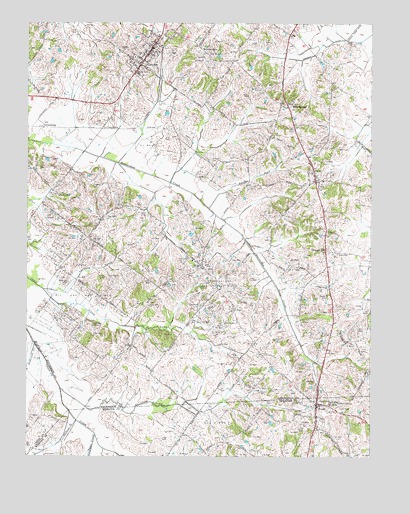
Poole, KY USGS Topographic Map
Click on map above to begin viewing in our Map Viewer.

This topographic map contains these locations and features:
Feature Name Type Latitude Longitude GNIS ID View Map
Anderson CreekStreamN37.6573°W87.7470°485939View Map
CairoPopulated PlaceN37.7081°W87.6458°488586View Map
Cairo Census Designated PlaceCensusN37.7062°W87.6432°2629582View Map
Cairo Fire DepartmentBuildingN37.7153°W87.6499°2636681View Map
Caldwell CreekStreamN37.6314°W87.7250°488593View Map
City of CorydonCivilN37.7402°W87.7064°2404135View Map
CorydonPopulated PlaceN37.7434°W87.7039°490133View Map
Corydon Fire DepartmentBuildingN37.7383°W87.7098°2636445View Map
DixiePopulated PlaceN37.6798°W87.6858°490918View Map
Dixon CemeteryCemeteryN37.6767°W87.7214°490930View Map
Duncan CemeteryCemeteryN37.6631°W87.7256°491297View Map
Hughes CemeteryCemeteryN37.7031°W87.7264°494745View Map
JonesburgPopulated PlaceN37.7209°W87.7442°508355View Map
Morehead CemeteryCemeteryN37.6745°W87.7364°498575View Map
North Fork Beaerdam CreekStreamN37.6967°W87.6836°499542View Map
Opossum CreekStreamN37.6731°W87.7439°499960View Map
PoolePopulated PlaceN37.6403°W87.6442°501069View Map
Poole Census Designated PlaceCensusN37.6393°W87.6446°2629667View Map
Poole Fire DepartmentBuildingN37.6324°W87.6450°2637067View Map
Rock SpringsPopulated PlaceN37.7259°W87.6547°502148View Map
Tapp CemeteryCemeteryN37.6300°W87.7008°504951View Map
Tunnel HillPopulated PlaceN37.6842°W87.6411°509243View Map
Union Hill ChurchChurchN37.6687°W87.7053°505805View Map
Whitelick CreekStreamN37.6445°W87.7372°506660View Map

Note: Coordinates in the location and feature list above are referenced to NAD83 datum.


Copyright (C) 2008-2025 Ryan Niemi / Sunset Dynamics ... All Rights Reserved