TopoQuest Logo
Do you find TopoQuest useful?
Help keep TopoQuest running and adding new maps/features by donating!
Bitcoin:  19c7KJd3qBynnjoSw5npx9KScwjBe4ifkT
Litecoin:  LXs6TkuXGGXo1vDsWCkWVdjQX94eUKd6ui
Home View Maps Find Maps Find Places Resources & Links


Portland, Indiana Topographic Map

USGS Map Title: Portland, IN
USGS Map MRC: 40084D8
DRG (GeoTIFF) Download: o40084d8.tif


Neighboring USGS Topographic Map Quads:


  Domestic, IN  
40085E1
 

  Geneva, IN  
40084E8
 

  New Corydon, IN  
40084E7
 

  Blaine, IN  
40085D1
 

  Portland, IN  
40084D8
 

  Fort Recovery, OH  
40084D7
 

  Ridgeville, IN  
40085C1
 

  Deerfield, IN  
40084C8
 

  Cosmos, OH  
40084C7


Map MRC Location:

N41°
W85°
N41°
W84°
H8 H7 H6 H5 H4 H3 H2 H1
G8 G7 G6 G5 G4 G3 G2 G1
F8 F7 F6 F5 F4 F3 F2 F1
E8 E7 E6 E5 E4 E3 E2 E1
D8 D7 D6 D5 D4 D3 D2 D1
C8 C7 C6 C5 C4 C3 C2 C1
B8 B7 B6 B5 B4 B3 B2 B1
A8 A7 A6 A5 A4 A3 A2 A1
N40°
W85°
N40°
W84°

Portland, IN USGS 1:24K Topographic Map Preview:
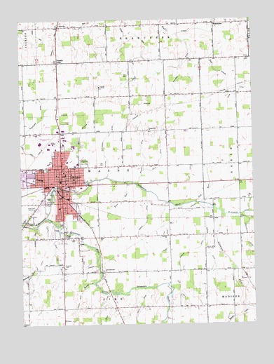
Portland, IN USGS Topographic Map
Click on map above to begin viewing in our Map Viewer.

This topographic map contains these locations and features:
Feature Name Type Latitude Longitude GNIS ID View Map
Alexander DitchCanalN40.4614°W84.9864°430063View Map
AntivillePopulated PlaceN40.4975°W84.9786°430219View Map
Antiville DitchCanalN40.4912°W84.9816°430220View Map
Ashley DitchCanalN40.3812°W84.9711°430313View Map
Berger DitchCanalN40.4050°W84.9008°430841View Map
Bockoven DitchCanalN40.4989°W84.9791°431278View Map
BricePopulated PlaceN40.4181°W84.8964°431505View Map
Buckeye CreekStreamN40.3920°W84.9611°431745View Map
Burkey DitchCanalN40.4175°W84.9322°431836View Map
City of PortlandCivilN40.4377°W84.9834°2396259View Map
College CornerPopulated PlaceN40.4109°W84.9772°432765View Map
Fairview ChurchChurchN40.4112°W84.9225°434341View Map
Freemyer DitchCanalN40.4803°W84.9139°434820View Map
Garfield SchoolSchoolN40.4370°W84.9725°434961View Map
General Shanks Elementary SchoolSchoolN40.4234°W84.9772°443280View Map
Golf BrookStreamN40.4153°W84.9808°435163View Map
Green Park CemeteryCemeteryN40.4238°W84.9937°435410View Map
Haynes ParkParkN40.4387°W84.9866°435923View Map
Hodge DitchCanalN40.4145°W84.9227°436266View Map
Houte DitchCanalN40.4475°W84.9239°436529View Map
IU Health Jay HospitalHospitalN40.4412°W84.9849°2660480View Map
Jaque CemeteryCemeteryN40.4265°W84.9837°436941View Map
Jay County Emergency Medical Services - PortlandBuildingN40.4420°W84.9833°2719313View Map
Jay County High SchoolSchoolN40.4312°W84.9750°447495View Map
Jay County Sheriff's OfficeBuildingN40.4326°W84.9801°2758392View Map
John Cring Memorial ForestParkN40.4617°W84.9569°437016View Map
Judge Haynes Elementary SchoolSchoolN40.4348°W84.9883°435924View Map
Karnes DitchCanalN40.4942°W84.9905°437170View Map
Kerns DitchCanalN40.4978°W84.9978°2612581View Map
LiberPopulated PlaceN40.4081°W84.9694°437813View Map
Liber CemeteryCemeteryN40.4103°W84.9705°437814View Map
Lincoln SchoolSchoolN40.4437°W84.9789°437932View Map
Little Salamonie ChurchChurchN40.3967°W84.9561°438139View Map
Little Salamonie RiverStreamN40.4187°W84.9869°438140View Map
McKinsey DitchCanalN40.4450°W84.9339°438907View Map
Miller SchoolSchoolN40.4106°W84.9583°439229View Map
Millers BranchStreamN40.4398°W84.9741°439231View Map
Old RunStreamN40.3914°W84.9216°440589View Map
Osterholt FarmsLocaleN40.3983°W84.9367°2567634View Map
Pleasant Hill ChurchChurchN40.4542°W84.9305°441282View Map
Pleasant RidgePopulated PlaceN40.4828°W84.9794°441291View Map
PortlandPopulated PlaceN40.4345°W84.9777°441471View Map
Portland Fire DepartmentBuildingN40.4503°W84.9822°2625885View Map
Portland Municipal AirportAirportN40.4534°W84.9910°449313View Map
Portland Police DepartmentBuildingN40.4359°W84.9777°2758026View Map
Race RunStreamN40.4337°W84.9427°441722View Map
Rest RunStreamN40.3878°W84.9544°441913View Map
Sale RunStreamN40.3900°W84.9347°442872View Map
Saw RunStreamN40.4250°W84.9061°443048View Map
Scholer DitchCanalN40.3998°W84.9150°443089View Map
Sycamore ForkStreamN40.4200°W84.8816°444513View Map
Township of WayneCivilN40.4397°W84.9608°454033View Map
Walnut CreekStreamN40.3817°W84.8797°445410View Map
WestchesterPopulated PlaceN40.4984°W84.8950°445827View Map
Young DitchCanalN40.4700°W84.8764°446412View Map

Note: Coordinates in the location and feature list above are referenced to NAD83 datum.


Copyright (C) 2008-2025 Ryan Niemi / Sunset Dynamics ... All Rights Reserved