TopoQuest Logo
Do you find TopoQuest useful?
Help keep TopoQuest running and adding new maps/features by donating!
Bitcoin:  19c7KJd3qBynnjoSw5npx9KScwjBe4ifkT
Litecoin:  LXs6TkuXGGXo1vDsWCkWVdjQX94eUKd6ui
Home View Maps Find Maps Find Places Resources & Links


New Corydon, Indiana Topographic Map

USGS Map Title: New Corydon, IN
USGS Map MRC: 40084E7
DRG (GeoTIFF) Download: o40084e7.tif


Neighboring USGS Topographic Map Quads:


  Berne, IN  
40084F8
 

  Willshire, OH  
40084F7
 

  Rockford, OH  
40084F6
 

  Geneva, IN  
40084E8
 

  New Corydon, IN  
40084E7
 

  Erastus, OH  
40084E6
 

  Portland, IN  
40084D8
 

  Fort Recovery, OH  
40084D7
 

  Coldwater, OH  
40084D6


Map MRC Location:

N41°
W85°
N41°
W84°
H8 H7 H6 H5 H4 H3 H2 H1
G8 G7 G6 G5 G4 G3 G2 G1
F8 F7 F6 F5 F4 F3 F2 F1
E8 E7 E6 E5 E4 E3 E2 E1
D8 D7 D6 D5 D4 D3 D2 D1
C8 C7 C6 C5 C4 C3 C2 C1
B8 B7 B6 B5 B4 B3 B2 B1
A8 A7 A6 A5 A4 A3 A2 A1
N40°
W85°
N40°
W84°

New Corydon, IN USGS 1:24K Topographic Map Preview:
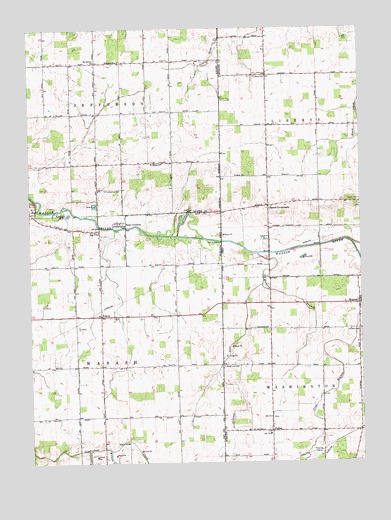
New Corydon, IN USGS Topographic Map
Click on map above to begin viewing in our Map Viewer.

This topographic map contains these locations and features:
Feature Name Type Latitude Longitude GNIS ID View Map
Alig FarmsLocaleN40.5028°W84.7833°2711050View Map
Beaver CreekStreamN40.5631°W84.7525°1065916View Map
Forest Hill School (historical)SchoolN40.5970°W84.7847°1053598View Map
Franks DrainStreamN40.5039°W84.8539°434788View Map
Hickory BranchStreamN40.5603°W84.7889°1041523View Map
Jay CityPopulated PlaceN40.5673°W84.8486°436949View Map
Jefferson SchoolSchoolN40.6156°W84.8402°436974View Map
Liberty CemeteryCemeteryN40.6109°W84.7895°1042502View Map
Lufborrow CemeteryCemeteryN40.5786°W84.8461°438401View Map
Lutheran CemeteryCemeteryN40.5378°W84.7505°1961377View Map
Mount Carmel ChurchChurchN40.6153°W84.8494°439554View Map
Muhlenkamp FarmsLocaleN40.5214°W84.7819°2711057View Map
New CorydonPopulated PlaceN40.5687°W84.8400°440037View Map
PaduaPopulated PlaceN40.5084°W84.7839°1058192View Map
Padua Post Office (historical)Post OfficeN40.5084°W84.7833°2037131View Map
R and H FarmsLocaleN40.5033°W84.7994°2711069View Map
Saint Anthony Catholic CemeteryCemeteryN40.5087°W84.7864°1961384View Map
Saint Anthony Catholic ChurchChurchN40.5089°W84.7852°1069696View Map
Saint Marys ChurchChurchN40.5862°W84.8247°442704View Map
Scherman DitchCanalN40.5245°W84.8039°443068View Map
Scherman DitchCanalN40.5350°W84.7969°1065859View Map
School Number 3 (historical)SchoolN40.5387°W84.7847°1053596View Map
School Number 9 (historical)SchoolN40.5678°W84.7850°1053597View Map
Skeels CemeteryCemeteryN40.5737°W84.7836°1961409View Map
Skeels CrossroadsPopulated PlaceN40.5737°W84.7847°1065333View Map
Skeels Crossroads Post Office (historical)Post OfficeN40.5737°W84.7847°2036674View Map
State Line CemeteryCemeteryN40.5278°W84.8019°1046652View Map
Stolz Field (historical)AirportN40.5528°W84.8305°449283View Map
Sudhoff Tree FarmLocaleN40.5319°W84.7833°2650310View Map
Township of JeffersonCivilN40.6158°W84.8402°453477View Map
Township of WabashCivilN40.5283°W84.8397°453965View Map
TrinityPopulated PlaceN40.5425°W84.8486°444890View Map
Wabash Post Office (historical)Post OfficeN40.5459°W84.7505°2037143View Map
Wilson CreekStreamN40.5039°W84.8458°446137View Map

Note: Coordinates in the location and feature list above are referenced to NAD83 datum.


Copyright (C) 2008-2024 Ryan Niemi / Sunset Dynamics ... All Rights Reserved