TopoQuest Logo
Do you find TopoQuest useful?
Help keep TopoQuest running and adding new maps/features by donating!
Bitcoin:  19c7KJd3qBynnjoSw5npx9KScwjBe4ifkT
Litecoin:  LXs6TkuXGGXo1vDsWCkWVdjQX94eUKd6ui
Home View Maps Find Maps Find Places Resources & Links


Potosi Peak, Montana Topographic Map

USGS Map Title: Potosi Peak, MT
USGS Map MRC: 45111E8
DRG (GeoTIFF) Download: o45111e8.tif


Neighboring USGS Topographic Map Quads:


  Manhead Mountain, MT  
45112F1
 

  Pony, MT  
45111F8
 

  Harrison, MT  
45111F7
 

  Noble Peak, MT  
45112E1
 

  Potosi Peak, MT  
45111E8
 

  Maltbys Mound, MT  
45111E7
 

  Copper Mountain, MT  
45112D1
 

  Ramshorn Mountain, MT  
45111D8
 

  Leonard Creek, MT  
45111D7


Map MRC Location:

N46°
W112°
N46°
W111°
H8 H7 H6 H5 H4 H3 H2 H1
G8 G7 G6 G5 G4 G3 G2 G1
F8 F7 F6 F5 F4 F3 F2 F1
E8 E7 E6 E5 E4 E3 E2 E1
D8 D7 D6 D5 D4 D3 D2 D1
C8 C7 C6 C5 C4 C3 C2 C1
B8 B7 B6 B5 B4 B3 B2 B1
A8 A7 A6 A5 A4 A3 A2 A1
N45°
W112°
N45°
W111°

Potosi Peak, MT USGS 1:24K Topographic Map Preview:
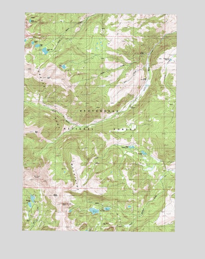
Potosi Peak, MT USGS Topographic Map
Click on map above to begin viewing in our Map Viewer.

This topographic map contains these locations and features:
Feature Name Type Latitude Longitude GNIS ID View Map
02S01W07CAB_02 SpringSpringN45.5899°W111.8991°810318View Map
02S02W07CAB_01 SpringSpringN45.5885°W111.8989°810294View Map
02S02W07CAB_03 SpringSpringN45.5891°W111.8994°810299View Map
02S02W07CAB_04 SpringSpringN45.5894°W111.8997°810310View Map
02S02W07CAB_05 SpringSpringN45.5891°W111.8997°810300View Map
02S02W07CAB_06 SpringSpringN45.5891°W111.9003°810301View Map
02S02W07CAB_08 SpringSpringN45.5875°W111.9002°810295View Map
10N03W27CADB01 WellWellN45.5933°W111.9697°810355View Map
Albro DamDamN45.5949°W111.9675°795322View Map
Albro LakeReservoirN45.5941°W111.9682°778914View Map
Belle MineMineN45.5055°W111.9842°804503View Map
Beulrh MineMineN45.5060°W111.9980°804475View Map
Beulrh MineMineN45.5058°W111.9978°779744View Map
Beulrh Mine CampLocaleN45.5083°W111.9944°779745View Map
Branham LakesLakeN45.5184°W111.9926°780366View Map
Branham Lakes Recreation SiteLocaleN45.5171°W111.9894°794805View Map
Branham PeaksSummitN45.5563°W111.9922°780367View Map
Bungalow GroupLocaleN45.5683°W111.9191°780597View Map
Camp Creek ReservoirReservoirN45.5989°W111.8806°806253View Map
Deep LakeReservoirN45.6030°W111.9838°795938View Map
Deep LakeLakeN45.6059°W111.9901°782221View Map
Hollow Top LakeLakeN45.6030°W111.9838°767955View Map
Hollowtop Lake DamDamN45.6049°W111.9842°795937View Map
Lady of the Lake PeakSummitN45.5149°W111.9683°785885View Map
Lower Branham DamDamN45.5133°W111.9925°796021View Map
Lower Branham LakeReservoirN45.5148°W111.9947°796022View Map
Mine PeakSummitN45.5563°W111.9919°787450View Map
Mount BradleySummitN45.5202°W111.9756°780350View Map
NE NE Section 23 MineMineN45.5674°W111.9314°804487View Map
New Deal MineMineN45.5049°W111.9355°804511View Map
New Deal MineMineN45.5044°W111.9353°806792View Map
Potosi (historical)LocaleN45.5888°W111.8980°1797465View Map
Potosi CampgroundLocaleN45.5716°W111.9139°801805View Map
Potosi CreekStreamN45.6019°W111.8980°789139View Map
Potosi Hot SpringsLocaleN45.5888°W111.8980°1797464View Map
Potosi Hot SpringsSpringN45.5896°W111.8997°789140View Map
Potosi PeakSummitN45.5877°W111.9822°789141View Map
Potosi Peak Tungsten MineMineN45.5794°W111.9836°804486View Map
Potosi Ranger StationLocaleN45.5738°W111.9080°789142View Map
Rock CreekStreamN45.5946°W111.8997°789662View Map
Skytop LakeLakeN45.6076°W111.9939°790630View Map
Sureshot LakeLakeN45.5453°W111.9019°791733View Map
Tobacco Root MountainsRangeN45.5544°W111.9744°792223View Map
Tungsten MineMineN45.5735°W111.9767°792451View Map
Twin LakesLakeN45.5120°W111.9394°792515View Map
Upper Branham DamDamN45.5166°W111.9925°798805View Map
Upper Branham LakeReservoirN45.5184°W111.9926°798806View Map
Upper Mason LakeLakeN45.6203°W111.9963°792642View Map
Upper Sureshot LakeLakeN45.5484°W111.9119°792655View Map
Warm SpringsSpringN45.6016°W111.9016°792827View Map

Note: Coordinates in the location and feature list above are referenced to NAD83 datum.


Copyright (C) 2008-2024 Ryan Niemi / Sunset Dynamics ... All Rights Reserved