TopoQuest Logo
Do you find TopoQuest useful?
Help keep TopoQuest running and adding new maps/features by donating!
Bitcoin:  19c7KJd3qBynnjoSw5npx9KScwjBe4ifkT
Litecoin:  LXs6TkuXGGXo1vDsWCkWVdjQX94eUKd6ui
Home View Maps Find Maps Find Places Resources & Links


Pony, Montana Topographic Map

USGS Map Title: Pony, MT
USGS Map MRC: 45111F8
DRG (GeoTIFF) Download: o45111f8.tif


Neighboring USGS Topographic Map Quads:


  Whitehall, MT  
45112G1
 

  Jefferson Island, MT  
45111G8
 

  Sappington, MT  
45111G7
 

  Manhead Mountain, MT  
45112F1
 

  Pony, MT  
45111F8
 

  Harrison, MT  
45111F7
 

  Noble Peak, MT  
45112E1
 

  Potosi Peak, MT  
45111E8
 

  Maltbys Mound, MT  
45111E7


Map MRC Location:

N46°
W112°
N46°
W111°
H8 H7 H6 H5 H4 H3 H2 H1
G8 G7 G6 G5 G4 G3 G2 G1
F8 F7 F6 F5 F4 F3 F2 F1
E8 E7 E6 E5 E4 E3 E2 E1
D8 D7 D6 D5 D4 D3 D2 D1
C8 C7 C6 C5 C4 C3 C2 C1
B8 B7 B6 B5 B4 B3 B2 B1
A8 A7 A6 A5 A4 A3 A2 A1
N45°
W112°
N45°
W111°

Pony, MT USGS 1:24K Topographic Map Preview:
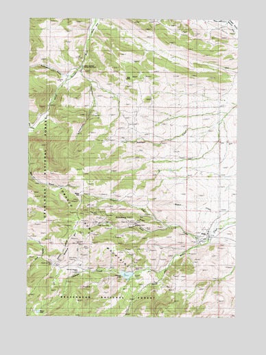
Pony, MT USGS Topographic Map
Click on map above to begin viewing in our Map Viewer.

This topographic map contains these locations and features:
Feature Name Type Latitude Longitude GNIS ID View Map
02S02W18DBCC01 WellWellN45.6588°W111.8947°810892View Map
02S02W18DCAD01 WellWellN45.6577°W111.8914°810872View Map
Atlantic and Pacific MineMineN45.6467°W111.9882°779188View Map
Bear Gulch MineMineN45.6902°W111.9939°804612View Map
Ben Harrison MineMineN45.6652°W111.9717°804338View Map
Boss Tweed MineMineN45.6635°W111.9586°780240View Map
Boss Tweed MineMineN45.6638°W111.9564°804153View Map
Brownback CreekStreamN45.7258°W111.9758°1797658View Map
Brownback GulchValleyN45.7260°W111.9794°778793View Map
Carmichael CanyonValleyN45.7299°W111.9700°794179View Map
Carmichael CreekStreamN45.7296°W111.9708°780950View Map
Cataract CreekStreamN45.6449°W111.9189°781049View Map
Cataract Creek DamDamN45.6433°W111.9375°794960View Map
Cataract LakeLakeN45.6426°W111.9409°806254View Map
Charcoal CreekStreamN45.6630°W111.9172°781158View Map
Clipper MineMineN45.6610°W111.9619°804343View Map
Clipper Post Office (historical)Post OfficeN45.6610°W111.9619°1797554View Map
East ButteSummitN45.7249°W111.9369°793660View Map
Garnet Gold MineMineN45.6452°W111.9367°783837View Map
Garnet Gold MineMineN45.6499°W111.9342°804154View Map
Gilliam Vermiculite MineMineN45.7244°W111.9480°804334View Map
Hog Hollow CreekStreamN45.7108°W111.8816°1797657View Map
Indiana University Geology Field StationSchoolN45.7291°W111.9692°785285View Map
Lone Wolf MineMineN45.6558°W111.9714°786502View Map
Magpie CreekStreamN45.6655°W111.8861°786778View Map
Marsh Lake DamDamN45.6283°W111.9925°796403View Map
Mason LakeReservoirN45.6269°W111.9936°786914View Map
Mount Cliff MineMineN45.6683°W111.9608°787738View Map
Mountain Cliff MineMineN45.6694°W111.9605°804156View Map
Mountain Meadow MineMineN45.6441°W111.9694°787756View Map
Mountain Meadow MineMineN45.6444°W111.9703°804155View Map
NE NW Section 24 MineMineN45.6555°W111.9175°804356View Map
NE NW Section 34 MineMineN45.7088°W111.9619°804488View Map
NW NE Section 14 MineMineN45.6694°W111.9369°804342View Map
NW NW Section 22 MineMineN45.6527°W111.9675°804347View Map
NW SE Section 17 MineMineN45.6638°W111.9967°804345View Map
PonyPopulated PlaceN45.6585°W111.8944°789074View Map
Pony (historical)LocaleN45.6585°W111.8944°1797467View Map
Pony Bible ChurchChurchN45.6585°W111.8944°1797458View Map
Pony Catholic Church (historical)ChurchN45.6585°W111.8944°1797457View Map
Pony CemeteryCemeteryN45.6574°W111.8814°1797432View Map
Pony Census Designated PlaceCensusN45.6628°W111.8826°2583835View Map
Pony CreekStreamN45.6580°W111.8928°789075View Map
Pony MineMineN45.6708°W111.9647°804337View Map
Pony MineMineN45.6680°W111.9544°789082View Map
Pony Post OfficePost OfficeN45.6583°W111.8924°1797468View Map
Pony School (historical)SchoolN45.6599°W111.8928°1797466View Map
Queens HillSummitN45.6569°W111.9744°793659View Map
Saint Johns Episcopal Church (historical)ChurchN45.6585°W111.8944°1797456View Map
Sams GulchValleyN45.7085°W111.9939°778831View Map
SE NE Section 21 MineMineN45.6499°W111.9703°804348View Map
SE NE Section 33 MineMineN45.7055°W111.9708°804489View Map
SE NW Section 16 MineMineN45.6646°W111.9758°804339View Map
SE NW Section 24 MineMineN45.6555°W111.9175°804355View Map
SE SE Section 13 MineMineN45.6555°W111.9175°804349View Map
South Fork Missouri DitchCanalN45.7488°W111.8836°791019View Map
Springside RanchLocaleN45.7071°W111.8861°794180View Map
Springside RanchLocaleN45.7063°W111.8886°791328View Map
Strawberry (historical)LocaleN45.6638°W111.9355°1797595View Map
Strawberry MineMineN45.6649°W111.9375°791594View Map
Strawberry MineMineN45.6638°W111.9314°804157View Map
Strawberry RidgeRidgeN45.6671°W111.9353°791596View Map
SW NW Section 18 MineMineN45.6624°W111.9036°804335View Map
SW SE Section 18 MineMineN45.6638°W111.8869°804346View Map
SW SE Section 34 MineMineN45.6999°W111.9522°804333View Map
SW SW Section 16 MineMineN45.6605°W111.9869°804344View Map
White Pine MineMineN45.6694°W111.9675°804336View Map
Windy PassGapN45.6763°W111.9675°793658View Map

Note: Coordinates in the location and feature list above are referenced to NAD83 datum.


Copyright (C) 2008-2024 Ryan Niemi / Sunset Dynamics ... All Rights Reserved