TopoQuest Logo
Do you find TopoQuest useful?
Help keep TopoQuest running and adding new maps/features by donating!
Bitcoin:  19c7KJd3qBynnjoSw5npx9KScwjBe4ifkT
Litecoin:  LXs6TkuXGGXo1vDsWCkWVdjQX94eUKd6ui
Home View Maps Find Maps Find Places Resources & Links


Potter, Arkansas Topographic Map

USGS Map Title: Potter, AR
USGS Map MRC: 34094E3
DRG (GeoTIFF) Download: o34094e3.tif


Neighboring USGS Topographic Map Quads:


  Mountain Fork, AR  
34094F4
 

  Rich Mountain, AR  
34094F3
 

  Acorn, AR  
34094F2
 

  Zafra, OK  
34094E4
 

  Potter, AR  
34094E3
 

  Mena, AR  
34094E2
 

  Cove, AR  
34094D4
 

  Vandervoort, AR  
34094D3
 

  Eagle Mountain, AR  
34094D2


Map MRC Location:

N35°
W95°
N35°
W94°
H8 H7 H6 H5 H4 H3 H2 H1
G8 G7 G6 G5 G4 G3 G2 G1
F8 F7 F6 F5 F4 F3 F2 F1
E8 E7 E6 E5 E4 E3 E2 E1
D8 D7 D6 D5 D4 D3 D2 D1
C8 C7 C6 C5 C4 C3 C2 C1
B8 B7 B6 B5 B4 B3 B2 B1
A8 A7 A6 A5 A4 A3 A2 A1
N34°
W95°
N34°
W94°

Potter, AR USGS 1:24K Topographic Map Preview:
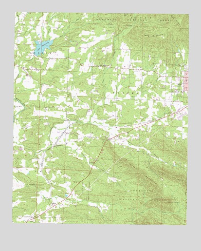
Potter, AR USGS Topographic Map
Click on map above to begin viewing in our Map Viewer.

This topographic map contains these locations and features:
Feature Name Type Latitude Longitude GNIS ID View Map
Antioch CemeteryCemeteryN34.5035°W94.3593°70450View Map
Bethel ChurchChurchN34.5573°W94.3355°70640View Map
Blowout MountainSummitN34.5143°W94.2641°70727View Map
Blue LakeReservoirN34.5484°W94.2935°81076View Map
Blue Lake DamDamN34.5484°W94.2935°81075View Map
Clear ForkStreamN34.5076°W94.2855°71167View Map
East Fork Powell CreekStreamN34.6090°W94.3474°71510View Map
Faith Missionary Baptist ChurchChurchN34.5882°W94.2588°64109View Map
Foster CemeteryCemeteryN34.5768°W94.3347°76954View Map
Foster Chapel (historical)ChurchN34.5770°W94.3349°63189View Map
Gann (historical)Populated PlaceN34.5473°W94.3447°63191View Map
Gann CemeteryCemeteryN34.5472°W94.3436°63192View Map
Gann ChapelChurchN34.5471°W94.3444°71716View Map
KOUA-FM (Mena)TowerN34.6112°W94.2724°85227View Map
Lake WilhelminaReservoirN34.6045°W94.3552°75887View Map
Lake Wilhelmina DamDamN34.6001°W94.3608°80642View Map
Lionsk Club Golf CourseLocaleN34.5668°W94.2519°64121View Map
Long MountainSummitN34.6112°W94.2774°72479View Map
Louise Durham Elementary SchoolSchoolN34.5887°W94.2504°83419View Map
McKinney CemeteryCemeteryN34.5478°W94.3000°72605View Map
McKinney CreekStreamN34.5598°W94.3205°72608View Map
Merren CreekStreamN34.5712°W94.3097°72627View Map
Mill CreekStreamN34.5129°W94.3138°72658View Map
Mount Calvary CemeteryCemeteryN34.5769°W94.2541°72747View Map
Mount Gillian CemeteryCemeteryN34.5911°W94.3530°72750View Map
Mountain View United Methodist ChurchChurchN34.5879°W94.2510°64126View Map
Oak Grove CemeteryCemeteryN34.5778°W94.2544°72908View Map
Old Potter Presbyterian ChurchChurchN34.5526°W94.3077°63237View Map
Old Potter School (historical)SchoolN34.5526°W94.3083°63238View Map
Olivers ChapelPopulated PlaceN34.5912°W94.2752°63239View Map
Polk County FairgroundsLocaleN34.5634°W94.2558°64129View Map
Polk County FairgroundsLocaleN34.5626°W94.2566°74597View Map
PotterPopulated PlaceN34.5537°W94.3391°78086View Map
Potter JunctionPopulated PlaceN34.5507°W94.3060°73178View Map
Potter MountainSummitN34.5301°W94.2830°73179View Map
Potter School (historical)SchoolN34.5557°W94.3391°63255View Map
Potter Station Fire District 13BuildingN34.5505°W94.3028°2116997View Map
RockyPopulated PlaceN34.5918°W94.3694°78202View Map
Rocky CemeteryCemeteryN34.5909°W94.3687°63259View Map
Rocky Methodist ChurchChurchN34.5915°W94.3697°63260View Map
Shady GrovePopulated PlaceN34.5932°W94.3144°63264View Map
Shady Grove ChurchChurchN34.5934°W94.3152°73519View Map
Shady Grove Fire and RescueBuildingN34.5929°W94.2928°2117113View Map
South 71 Church of ChristChurchN34.5648°W94.2622°64134View Map
Thompson CreekStreamN34.5462°W94.3474°73861View Map
Township of EagleCivilN34.5375°W94.3523°68988View Map
Township of PotterCivilN34.5762°W94.2918°68997View Map
Two Mile (historical)Populated PlaceN34.5112°W94.3477°63276View Map
Two Mile Baptist ChurchChurchN34.5107°W94.3474°78608View Map

Note: Coordinates in the location and feature list above are referenced to NAD83 datum.


Copyright (C) 2008-2025 Ryan Niemi / Sunset Dynamics ... All Rights Reserved