TopoQuest Logo
Do you find TopoQuest useful?
Help keep TopoQuest running and adding new maps/features by donating!
Bitcoin:  19c7KJd3qBynnjoSw5npx9KScwjBe4ifkT
Litecoin:  LXs6TkuXGGXo1vDsWCkWVdjQX94eUKd6ui
Home View Maps Find Maps Find Places Resources & Links


Pounding Mill, Virginia Topographic Map

USGS Map Title: Pounding Mill, VA
USGS Map MRC: 37081A6
DRG (GeoTIFF) Download: o37081a6.tif


Neighboring USGS Topographic Map Quads:


  Jewell Ridge, VA  
37081B7
 

  Amonate, VA  
37081B6
 

  Tazewell North, VA  
37081B5
 

  Richlands, VA  
37081A7
 

  Pounding Mill, VA  
37081A6
 

  Tazewell South, VA  
37081A5
 

  Saltville, VA  
36081H7
 

  Broadford, VA  
36081H6
 

  Chatham Hill, VA  
36081H5


Map MRC Location:

N38°
W82°
N38°
W81°
H8 H7 H6 H5 H4 H3 H2 H1
G8 G7 G6 G5 G4 G3 G2 G1
F8 F7 F6 F5 F4 F3 F2 F1
E8 E7 E6 E5 E4 E3 E2 E1
D8 D7 D6 D5 D4 D3 D2 D1
C8 C7 C6 C5 C4 C3 C2 C1
B8 B7 B6 B5 B4 B3 B2 B1
A8 A7 A6 A5 A4 A3 A2 A1
N37°
W82°
N37°
W81°

Pounding Mill, VA USGS 1:24K Topographic Map Preview:
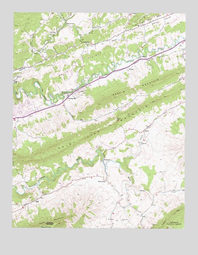
Pounding Mill, VA USGS Topographic Map
Click on map above to begin viewing in our Map Viewer.

This topographic map contains these locations and features:
Feature Name Type Latitude Longitude GNIS ID View Map
Bald RockSummitN37.0468°W81.7187°1497596View Map
Bandys Chapel (historical)ChurchN37.1084°W81.6998°1497598View Map
Baptist ValleyValleyN37.1048°W81.6977°1481449View Map
Baptist Valley School (historical)SchoolN37.1151°W81.6684°1497599View Map
BustheadPopulated PlaceN37.1073°W81.6982°1499200View Map
Cave Section BranchStreamN37.0721°W81.6290°1497616View Map
Cedar Hills RacewayLocaleN37.0865°W81.7473°1491121View Map
CliffieldPopulated PlaceN37.0979°W81.6568°1499270View Map
Cliffield School (historical)SchoolN37.0993°W81.6573°1497621View Map
Cove SchoolSchoolN37.0190°W81.6712°1482747View Map
Cove Volunteer Fire DepartmentBuildingN37.0196°W81.6724°2721195View Map
Deskin CreekStreamN37.1101°W81.6265°1482984View Map
Earl BranchStreamN37.1029°W81.6573°1497630View Map
GillespiePopulated PlaceN37.0918°W81.6707°1499473View Map
Green PlacePopulated PlaceN37.0132°W81.7401°1497652View Map
Greens ChapelChurchN37.0157°W81.7329°1483824View Map
Joe WhitesPopulated PlaceN37.0151°W81.6734°1497666View Map
Laurel ForkStreamN37.1193°W81.7115°1484701View Map
Laurel GapGapN37.0634°W81.6743°1488650View Map
LibertyPopulated PlaceN37.0568°W81.6540°1499660View Map
Liberty CreekStreamN37.0371°W81.6712°1484793View Map
Liberty School (historical)SchoolN37.0629°W81.6473°1497675View Map
Little River School (historical)SchoolN37.0246°W81.7329°1497678View Map
Lost Mill (historical)LocaleN37.0498°W81.6565°1497683View Map
Lowe BranchStreamN37.1151°W81.7034°1485113View Map
Maiden SpringSpringN37.0321°W81.6818°1497684View Map
Maiden SpringPopulated PlaceN37.0282°W81.6823°1485159View Map
Maiden Spring CreekStreamN37.0354°W81.6718°1485160View Map
Maiden Spring Fort (historical)MilitaryN37.0275°W81.6825°1738265View Map
McGuire ValleyValleyN37.1155°W81.6929°1485303View Map
Mouth of LaurelPopulated PlaceN37.1171°W81.7118°1499779View Map
Paint Lick MountainSummitN37.0734°W81.6487°1499834View Map
Paint RockSummitN37.0446°W81.7171°1497700View Map
Pounding MillPopulated PlaceN37.0754°W81.7087°1499907View Map
Pounding Mill BranchStreamN37.0757°W81.7126°1486397View Map
Pounding Mill Post OfficePost OfficeN37.0620°W81.7474°2766411View Map
Pounding Mill School (historical)SchoolN37.0776°W81.7107°1497707View Map
Raven Nest BranchStreamN37.1007°W81.7351°1486521View Map
Raven Nest School (historical)SchoolN37.1040°W81.7346°1497711View Map
RockhousePopulated PlaceN37.0384°W81.6834°1499981View Map
Smith RidgeRidgeN37.0951°W81.7009°1487347View Map
Thompson ValleyValleyN37.0264°W81.6344°1487887View Map
Van DykePopulated PlaceN37.1123°W81.7212°1488575View Map
Ward CoveBasinN37.0048°W81.6726°1488191View Map
Ward CoveValleyN37.0202°W81.6736°1488192View Map
West End ChurchChurchN37.1168°W81.6582°1488249View Map
Western DistrictCivilN37.0713°W81.7319°1927563View Map
Whites StorePopulated PlaceN37.0082°W81.6559°1497765View Map

Note: Coordinates in the location and feature list above are referenced to NAD83 datum.


Copyright (C) 2008-2025 Ryan Niemi / Sunset Dynamics ... All Rights Reserved