TopoQuest Logo
Do you find TopoQuest useful?
Help keep TopoQuest running and adding new maps/features by donating!
Bitcoin:  19c7KJd3qBynnjoSw5npx9KScwjBe4ifkT
Litecoin:  LXs6TkuXGGXo1vDsWCkWVdjQX94eUKd6ui
Home View Maps Find Maps Find Places Resources & Links


Innis, Louisiana Topographic Map

USGS Map Title: Innis, LA
USGS Map MRC: 30091H6
DRG (GeoTIFF) Download: o30091h6.tif


Neighboring USGS Topographic Map Quads:


  Big Bend, LA  
31091A7
 

  Turnbull Island, LA  
31091A6
 

  Fort Adams, MS  
31091A5
 

  Simmesport, LA  
30091H7
 

  Innis, LA  
30091H6
 

  Angola, LA  
30091H5
 

  Bayou Current, LA  
30091G7
 

  Batchelor, LA  
30091G6
 

  Lacour, LA  
30091G5


Map MRC Location:

N31°
W92°
N31°
W91°
H8 H7 H6 H5 H4 H3 H2 H1
G8 G7 G6 G5 G4 G3 G2 G1
F8 F7 F6 F5 F4 F3 F2 F1
E8 E7 E6 E5 E4 E3 E2 E1
D8 D7 D6 D5 D4 D3 D2 D1
C8 C7 C6 C5 C4 C3 C2 C1
B8 B7 B6 B5 B4 B3 B2 B1
A8 A7 A6 A5 A4 A3 A2 A1
N30°
W92°
N30°
W91°

Innis, LA USGS 1:24K Topographic Map Preview:
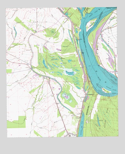
Innis, LA USGS Topographic Map
Click on map above to begin viewing in our Map Viewer.

This topographic map contains these locations and features:
Feature Name Type Latitude Longitude GNIS ID View Map
Angola LandingPopulated PlaceN30.9441°W91.6473°542930View Map
Bayou FisherStreamN30.9410°W91.7210°553453View Map
Bayou HazardStreamN30.8924°W91.7207°553468View Map
Bayou LettsworthStreamN30.8999°W91.6779°553483View Map
Big Lake MoreauLakeN30.9373°W91.6782°553654View Map
Black LakeLakeN30.9774°W91.7385°553683View Map
Boggy LakeLakeN30.9500°W91.6955°553740View Map
Camp CLocaleN30.9521°W91.6265°1631446View Map
Camp DLocaleN30.9691°W91.6312°550161View Map
Camp GLocaleN30.9710°W91.6446°550164View Map
Carr Cut-OffChannelN30.9910°W91.6635°549436View Map
Carr PointCapeN30.9946°W91.6562°533778View Map
Carr Point RevetmentLeveeN30.9852°W91.6654°549437View Map
Carrs Point Landing (historical)LocaleN30.9980°W91.6465°544615View Map
Charity LakeLakeN30.9494°W91.6317°553953View Map
Chinns ChapelChurchN30.9318°W91.6987°533924View Map
Clear LakeSwampN30.9592°W91.6879°533990View Map
Crooked BayouStreamN30.9618°W91.7468°534254View Map
Dry BayouStreamN30.9088°W91.7179°534591View Map
Field LakeSwampN30.9652°W91.7157°534946View Map
Flat LakeLakeN30.9685°W91.6702°554430View Map
Good Faith CemeteryCemeteryN30.8957°W91.6737°549441View Map
Good Faith ChurchChurchN30.8963°W91.6732°535267View Map
Good Faith School (historical)SchoolN30.8955°W91.6732°549442View Map
Grassy LakeLakeN30.9465°W91.6886°554591View Map
Hog PointCapeN30.9166°W91.6276°535705View Map
Hunter CreekStreamN30.9718°W91.6590°535864View Map
InnisPopulated PlaceN30.8780°W91.6807°554834View Map
Innis High SchoolSchoolN30.8763°W91.6798°546228View Map
Innis Post OfficePost OfficeN30.8785°W91.6818°1630519View Map
Innis Volunteer Fire DepartmentBuildingN30.8778°W91.6778°2691641View Map
Jones LakeSwampN30.9626°W91.6838°536111View Map
KellerPopulated PlaceN30.9418°W91.7221°536153View Map
LettsworthPopulated PlaceN30.9335°W91.7048°555026View Map
Lettsworth Post OfficePost OfficeN30.9346°W91.7129°1630526View Map
Levee CemeteryCemeteryN30.9155°W91.6982°536411View Map
Levee LakeLakeN30.9261°W91.6694°555027View Map
Levi LakeSwampN30.9770°W91.6975°536412View Map
Limeless LakeLakeN30.8909°W91.6475°555040View Map
Little Lake MoreauLakeN30.9528°W91.6911°555088View Map
Long LakeLakeN30.9543°W91.6982°555140View Map
McIntyre LakeLakeN30.9474°W91.7077°555273View Map
Miles BarBarN30.9180°W91.6410°537085View Map
Monkey IslandIslandN30.9918°W91.6260°537179View Map
Morefield CemeteryCemeteryN30.9332°W91.7068°537198View Map
Mount Carmel ChurchChurchN30.9918°W91.6812°537307View Map
Mount Olive CemeteryCemeteryN30.9071°W91.6937°549455View Map
Mount Olive ChurchChurchN30.9077°W91.6929°537356View Map
New Zion ChurchChurchN30.9746°W91.7193°537646View Map
Parish Governing Authority District 1CivilN30.9152°W91.7111°1929750View Map
Phillips LakeLakeN30.9486°W91.6788°555635View Map
Phillipston (historical)Populated PlaceN30.9685°W91.6868°549462View Map
Pikes Peak CemeteryCemeteryN30.9674°W91.7046°538135View Map
Pikes Peak LakeSwampN30.9663°W91.7185°538136View Map
Pleasant Grove ChurchChurchN30.9027°W91.6657°538243View Map
Pointe Coupee Parish Library Innis BranchBuildingN30.8759°W91.6792°2603114View Map
Prevailing Word Christian CenterChurchN30.8782°W91.6815°2602415View Map
Raccourci CutoffBendN30.9207°W91.6312°538472View Map
Red River LandingPopulated PlaceN30.9593°W91.6651°543612View Map
Round LakeLakeN30.9136°W91.6825°555846View Map
Saint Marys CemeteryCemeteryN30.9427°W91.7240°538981View Map
Saint Marys ChurchChurchN30.9413°W91.7223°549472View Map
Saint Stephens CemeteryCemeteryN30.8974°W91.6682°549474View Map
Saint Stephens Episcopal ChurchChurchN30.8974°W91.6679°555947View Map
Sawmill LakeSwampN30.8841°W91.6476°539200View Map
Shreves BarBarN30.9838°W91.6540°539360View Map
Shreves CutoffBendN30.9943°W91.6510°539361View Map
SmithlandPopulated PlaceN30.9102°W91.6637°556069View Map
Smithland LandingLocaleN30.9260°W91.6535°549476View Map
Sunnyside CemeteryCemeteryN30.9599°W91.7226°539733View Map
TorrasPopulated PlaceN30.9896°W91.6790°543728View Map
Torras LandingPopulated PlaceN30.9696°W91.6671°543729View Map
True Vine CemeteryCemeteryN30.9980°W91.7373°540003View Map
Ward TwoCivilN30.9052°W91.7179°545159View Map
WilliamsportPopulated PlaceN30.8952°W91.6673°540442View Map

Note: Coordinates in the location and feature list above are referenced to NAD83 datum.


Copyright (C) 2008-2024 Ryan Niemi / Sunset Dynamics ... All Rights Reserved