TopoQuest Logo
Do you find TopoQuest useful?
Help keep TopoQuest running and adding new maps/features by donating!
Bitcoin:  19c7KJd3qBynnjoSw5npx9KScwjBe4ifkT
Litecoin:  LXs6TkuXGGXo1vDsWCkWVdjQX94eUKd6ui
Home View Maps Find Maps Find Places Resources & Links


Plaucheville, Louisiana Topographic Map

USGS Map Title: Plaucheville, LA
USGS Map MRC: 30091H8
DRG (GeoTIFF) Download: o30091h8.tif


Neighboring USGS Topographic Map Quads:


  Marksville South, LA  
31092A1
 

  Moreauville, LA  
31091A8
 

  Big Bend, LA  
31091A7
 

  Cottonport, LA  
30092H1
 

  Plaucheville, LA  
30091H8
 

  Simmesport, LA  
30091H7
 

  Morrow, LA  
30092G1
 

  Bayou Jack, LA  
30091G8
 

  Bayou Current, LA  
30091G7


Map MRC Location:

N31°
W92°
N31°
W91°
H8 H7 H6 H5 H4 H3 H2 H1
G8 G7 G6 G5 G4 G3 G2 G1
F8 F7 F6 F5 F4 F3 F2 F1
E8 E7 E6 E5 E4 E3 E2 E1
D8 D7 D6 D5 D4 D3 D2 D1
C8 C7 C6 C5 C4 C3 C2 C1
B8 B7 B6 B5 B4 B3 B2 B1
A8 A7 A6 A5 A4 A3 A2 A1
N30°
W92°
N30°
W91°

Plaucheville, LA USGS 1:24K Topographic Map Preview:
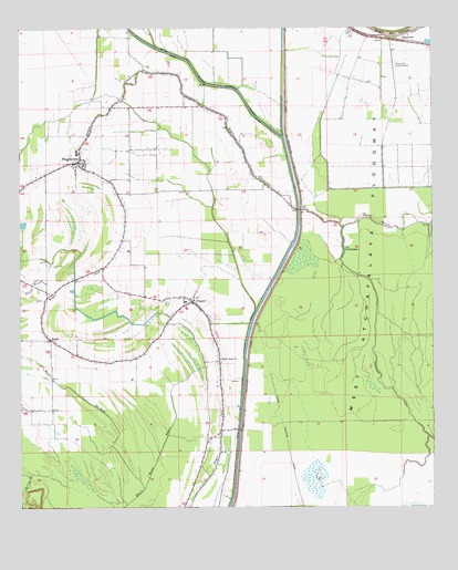
Plaucheville, LA USGS Topographic Map
Click on map above to begin viewing in our Map Viewer.

This topographic map contains these locations and features:
Feature Name Type Latitude Longitude GNIS ID View Map
Bayou ChoupiqueStreamN30.9532°W91.9157°553436View Map
Bayou du LacStreamN30.9482°W91.9023°554975View Map
Bayou DuBrocStreamN30.8802°W91.9632°532574View Map
Bayou Jacque ChurchChurchN30.9144°W91.9387°532637View Map
BodocPopulated PlaceN30.9191°W91.9907°533256View Map
Bodoc Church (historical)ChurchN30.9374°W91.9754°549396View Map
Bodoc Post Office (historical)Post OfficeN30.9282°W91.9482°1630191View Map
BroussardPopulated PlaceN30.8932°W91.9435°549397View Map
Choupique CanalCanalN30.9060°W91.8876°533940View Map
DupontPopulated PlaceN30.9294°W91.9479°554303View Map
Dupont Volunteer Fire Department Main StationBuildingN30.9298°W91.9514°2672905View Map
DuPont Volunteer Fire Department Sub Station 1BuildingN30.9272°W91.9926°2673065View Map
DuPont Volunteer Fire Department Sub Station 2BuildingN30.8901°W91.9448°2673028View Map
Immaculate Conception Catholic ChurchChurchN30.9292°W91.9475°2601944View Map
Lac ChoupiqueLakeN30.9419°W91.9021°553987View Map
Mater Doloresa Catholic ChurchChurchN30.9652°W91.9827°2602249View Map
North Bayou Jack Oil and Gas FieldOilfieldN30.8946°W91.9682°545557View Map
PlauchevillePopulated PlaceN30.9655°W91.9818°543583View Map
Plaucheville CemeteryCemeteryN30.9682°W91.9812°545563View Map
Plaucheville Elementary SchoolSchoolN30.9677°W91.9828°545564View Map
Plaucheville High School (historical)SchoolN30.9682°W91.9829°545565View Map
Plaucheville Post OfficePost OfficeN30.9650°W91.9806°1630226View Map
Plaucheville Volunteer Fire DepartmentBuildingN30.9650°W91.9807°2672925View Map
RosewoodPopulated PlaceN30.9980°W91.8835°543629View Map
Saint Joseph Elementary and High SchoolSchoolN30.9649°W91.9834°545573View Map
Saint Joseph Junior High SchoolSchoolN30.9649°W91.9832°545574View Map
Village of PlauchevilleCivilN30.9647°W91.9837°2407526View Map
Ward EightCivilN30.9349°W91.9746°544917View Map
WD Flyers AirportAirportN30.9975°W91.8847°545570View Map
West Protection LeveeLeveeN30.9807°W91.9185°1628484View Map

Note: Coordinates in the location and feature list above are referenced to NAD83 datum.


Copyright (C) 2008-2025 Ryan Niemi / Sunset Dynamics ... All Rights Reserved