TopoQuest Logo
Do you find TopoQuest useful?
Help keep TopoQuest running and adding new maps/features by donating!
Bitcoin:  19c7KJd3qBynnjoSw5npx9KScwjBe4ifkT
Litecoin:  LXs6TkuXGGXo1vDsWCkWVdjQX94eUKd6ui
Home View Maps Find Maps Find Places Resources & Links


Pride, Alabama Topographic Map

USGS Map Title: Pride, AL
USGS Map MRC: 34087F7
DRG (GeoTIFF) Download: o34087f7.tif


Neighboring USGS Topographic Map Quads:


  Cherokee, AL  
34087G8
 

  Sinking Creek, AL  
34087G7
 

  Florence, AL  
34087G6
 

  Barton, AL  
34087F8
 

  Pride, AL  
34087F7
 

  Tuscumbia, AL  
34087F6
 

  Pleasant Grove, AL  
34087E8
 

  Frankfort, AL  
34087E7
 

  Russellville, AL  
34087E6


Map MRC Location:

N35°
W88°
N35°
W87°
H8 H7 H6 H5 H4 H3 H2 H1
G8 G7 G6 G5 G4 G3 G2 G1
F8 F7 F6 F5 F4 F3 F2 F1
E8 E7 E6 E5 E4 E3 E2 E1
D8 D7 D6 D5 D4 D3 D2 D1
C8 C7 C6 C5 C4 C3 C2 C1
B8 B7 B6 B5 B4 B3 B2 B1
A8 A7 A6 A5 A4 A3 A2 A1
N34°
W88°
N34°
W87°

Pride, AL USGS 1:24K Topographic Map Preview:
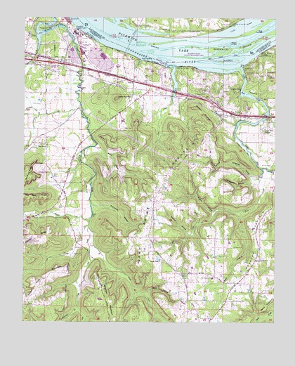
Pride, AL USGS Topographic Map
Click on map above to begin viewing in our Map Viewer.

This topographic map contains these locations and features:
Feature Name Type Latitude Longitude GNIS ID View Map
Barton SchoolSchoolN34.7309°W87.8684°132811View Map
Basden CemeteryCemeteryN34.6526°W87.8459°113537View Map
Bethel School (historical)SchoolN34.6445°W87.7936°132817View Map
Buck IslandIslandN34.7320°W87.7767°115129View Map
Buck Island ChuteChannelN34.7345°W87.7739°115133View Map
Cane Creek Cumberland Presbyterian ChurchChurchN34.6859°W87.8620°153119View Map
Cedar Hills EstatesPopulated PlaceN34.7056°W87.7531°115802View Map
Chapel Hill Church of ChristChurchN34.7184°W87.7892°155023View Map
Church of Peace (historical)ChurchN34.7220°W87.8367°141132View Map
Coffee SloughStreamN34.7412°W87.7875°116354View Map
Colbert CountyCivilN34.7004°W87.8050°161542View Map
Colbert County ParkParkN34.7006°W87.7667°146237View Map
Colbert Steam PlantLocaleN34.7451°W87.8484°164308View Map
Collier Landing (historical)LocaleN34.7423°W87.7695°145122View Map
Cornelius CreekStreamN34.7126°W87.8461°116653View Map
Counterfeit HollowValleyN34.6840°W87.7606°116701View Map
Devils HollowValleyN34.6373°W87.8142°117259View Map
Donley CemeteryCemeteryN34.6898°W87.7525°117374View Map
Dry CreekStreamN34.7298°W87.8000°117550View Map
Dry CreekStreamN34.6634°W87.8423°117589View Map
Fielder RidgeRidgeN34.6601°W87.8695°118267View Map
Frankfort Road ChurchChurchN34.6506°W87.7589°118593View Map
Garrets LakeReservoirN34.6509°W87.8077°118847View Map
Gatesville (historical)Populated PlaceN34.7298°W87.8459°132893View Map
Gibbs CemeteryCemeteryN34.7145°W87.8670°118921View Map
Gibson TowheadIslandN34.7334°W87.8056°150832View Map
Goat TowheadIslandN34.7454°W87.7548°119074View Map
Greenhill BranchStreamN34.7098°W87.8673°112852View Map
Greenhill CemeteryCemeteryN34.7098°W87.8748°112853View Map
Greenhill HollowValleyN34.6840°W87.7609°119363View Map
Hawk PridePopulated PlaceN34.6856°W87.8039°132905View Map
Hawk Pride Church of ChristChurchN34.6884°W87.8006°119864View Map
Hawk Pride MountainSummitN34.6790°W87.8109°119865View Map
Henson CreekStreamN34.6679°W87.8414°119986View Map
Hesters Store (historical)LocaleN34.6412°W87.7664°141130View Map
Holland CemeteryCemeteryN34.6556°W87.7700°120237View Map
Horseshoe BendBendN34.7456°W87.8659°120423View Map
Keenum HollowValleyN34.6615°W87.7931°121102View Map
Keeton CemeteryCemeteryN34.6787°W87.8492°121103View Map
Kellar Quarry LandingLocaleN34.7345°W87.7581°156546View Map
Keller QuarryMineN34.7348°W87.7573°132930View Map
Lick CreekStreamN34.6645°W87.8428°152060View Map
Little Bear CreekStreamN34.7298°W87.7675°152082View Map
Little Buck Island (historical)IslandN34.7320°W87.7834°132944View Map
Little Buck ShoalsBarN34.7345°W87.7736°142083View Map
Little Zion (historical)Populated PlaceN34.6329°W87.8723°155427View Map
Littleville DivisionCivilN34.6504°W87.7805°165714View Map
Locust Shores Volunteer Fire and RescueBuildingN34.7176°W87.7871°2682798View Map
Mill CreekStreamN34.6879°W87.7567°152324View Map
Mount Moriah Missionary Baptist ChurchChurchN34.7173°W87.7945°152451View Map
Nazareth Primitive Baptist ChurchChurchN34.7276°W87.8611°152586View Map
New BethelPopulated PlaceN34.6451°W87.7917°132979View Map
New Bethel Baptist ChurchChurchN34.6445°W87.7931°152608View Map
New Bethel Elementary SchoolSchoolN34.6431°W87.7806°165491View Map
New Bethel Memorial CemeteryCemeteryN34.6456°W87.7936°132980View Map
New Bethel Volunteer Fire DepartmentBuildingN34.6448°W87.7927°2682762View Map
Noman Towhead (historical)IslandN34.7426°W87.7598°150835View Map
Oak Grove Church (historical)ChurchN34.7109°W87.7667°132988View Map
Oak Grove Missionary Baptist ChurchChurchN34.7115°W87.7756°152739View Map
Perrys Landing (historical)LocaleN34.7409°W87.7967°142148View Map
Piney Grove Church of ChristChurchN34.6265°W87.7814°152946View Map
Pippin TowheadIslandN34.7398°W87.7686°124911View Map
Potato Hill MountainSummitN34.7173°W87.8378°133000View Map
PridePopulated PlaceN34.7237°W87.8206°163938View Map
Pride Baptist ChurchChurchN34.7187°W87.8181°155324View Map
Pride BluffCliffN34.7370°W87.8300°125276View Map
Pride CemeteryCemeteryN34.7106°W87.7764°125277View Map
Pride LandingLocaleN34.7329°W87.8173°156936View Map
Pride QuarryMineN34.7281°W87.8106°2568273View Map
Pride School (historical)SchoolN34.7104°W87.7753°133001View Map
Prides Ferry (historical)CrossingN34.7362°W87.8181°133002View Map
Red RockPillarN34.6898°W87.8700°125495View Map
Red RockPopulated PlaceN34.6979°W87.8639°125496View Map
Red Rock ChurchChurchN34.7259°W87.8645°125497View Map
Red Rock ChurchChurchN34.6976°W87.8661°133004View Map
Red Rock School (historical)SchoolN34.6870°W87.8628°133005View Map
Red Rock ValleyValleyN34.7168°W87.8481°125499View Map
Rogers HollowValleyN34.6704°W87.7806°125907View Map
Rutland CemeteryCemeteryN34.6720°W87.8575°126053View Map
Sand MountainSummitN34.7170°W87.8286°126320View Map
Sandfall MountainSummitN34.7037°W87.7834°126352View Map
Seven Mile Island Public Shooting AreaParkN34.7379°W87.7689°148828View Map
Sevenmile IslandIslandN34.7443°W87.7517°126565View Map
Sherrod CemeteryCemeteryN34.7026°W87.7681°126702View Map
Shoal CreekStreamN34.6701°W87.7673°126783View Map
Sinking CreekStreamN34.7473°W87.8295°153454View Map
Tanyard BranchStreamN34.7365°W87.8684°127684View Map
Thompson HollowValleyN34.6734°W87.8409°127909View Map
Timber Knob MountainSummitN34.6454°W87.8603°127985View Map
Wagnon MountainSummitN34.6318°W87.8325°128496View Map
Walker SloughGutN34.7487°W87.8292°142247View Map
Waterfall BranchStreamN34.6318°W87.8481°128620View Map
Wheeler MountainSummitN34.6565°W87.7564°128836View Map
Whitley BranchStreamN34.7334°W87.8711°128923View Map
Willis HollowValleyN34.6968°W87.8395°129052View Map
Woodland Landing (historical)LocaleN34.7401°W87.8270°157354View Map
Zion Number 1 Missionary Baptist ChurchChurchN34.7334°W87.8686°154063View Map

Note: Coordinates in the location and feature list above are referenced to NAD83 datum.


Copyright (C) 2008-2024 Ryan Niemi / Sunset Dynamics ... All Rights Reserved