TopoQuest Logo
Do you find TopoQuest useful?
Help keep TopoQuest running and adding new maps/features by donating!
Bitcoin:  19c7KJd3qBynnjoSw5npx9KScwjBe4ifkT
Litecoin:  LXs6TkuXGGXo1vDsWCkWVdjQX94eUKd6ui
Home View Maps Find Maps Find Places Resources & Links


Barton, Alabama Topographic Map

USGS Map Title: Barton, AL
USGS Map MRC: 34087F8
DRG (GeoTIFF) Download: o34087f8.tif


Neighboring USGS Topographic Map Quads:


  Margerum, AL  
34088G1
 

  Cherokee, AL  
34087G8
 

  Sinking Creek, AL  
34087G7
 

  Bishop, AL  
34088F1
 

  Barton, AL  
34087F8
 

  Pride, AL  
34087F7
 

  Pleasant Site, AL  
34088E1
 

  Pleasant Grove, AL  
34087E8
 

  Frankfort, AL  
34087E7


Map MRC Location:

N35°
W88°
N35°
W87°
H8 H7 H6 H5 H4 H3 H2 H1
G8 G7 G6 G5 G4 G3 G2 G1
F8 F7 F6 F5 F4 F3 F2 F1
E8 E7 E6 E5 E4 E3 E2 E1
D8 D7 D6 D5 D4 D3 D2 D1
C8 C7 C6 C5 C4 C3 C2 C1
B8 B7 B6 B5 B4 B3 B2 B1
A8 A7 A6 A5 A4 A3 A2 A1
N34°
W88°
N34°
W87°

Barton, AL USGS 1:24K Topographic Map Preview:
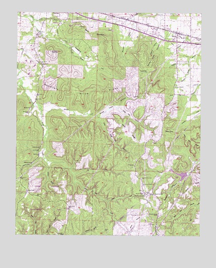
Barton, AL USGS Topographic Map
Click on map above to begin viewing in our Map Viewer.

This topographic map contains these locations and features:
Feature Name Type Latitude Longitude GNIS ID View Map
BartonPopulated PlaceN34.7387°W87.8911°113523View Map
Barton CemeteryCemeteryN34.7365°W87.8828°113527View Map
Barton Compressor StationLocaleN34.6470°W87.9114°164281View Map
Barton Elementary SchoolSchoolN34.7354°W87.8939°149159View Map
Barton Volunteer Fire DepartmentBuildingN34.7383°W87.9083°2682678View Map
Bear Den HollowValleyN34.6420°W87.8773°113681View Map
Beeswax BranchStreamN34.7226°W87.8834°113832View Map
Bugg Mill HollowValleyN34.6973°W87.9306°115163View Map
Burcham HollowValleyN34.7426°W87.9211°115211View Map
Cherokee BranchStreamN34.7462°W87.9895°115999View Map
Cherokee SpringSpringN34.7468°W87.9586°149276View Map
Davis Temple CemeteryCemeteryN34.7043°W87.9539°163669View Map
DeMint HollowValleyN34.7356°W87.9039°117155View Map
Denton SpringSpringN34.6741°W87.9842°117234View Map
Dry CreekStreamN34.6590°W87.9611°117548View Map
Dug Post OfficePost OfficeN34.6479°W87.9056°169294View Map
Fawn LakeReservoirN34.6634°W87.8834°132034View Map
Fawn Lake DamDamN34.6634°W87.8834°132035View Map
Hamilton CreekStreamN34.6951°W87.9828°119637View Map
Highway 247 Volunteer Fire DepartmentBuildingN34.6268°W87.9057°2683075View Map
Horseapple CoveValleyN34.7368°W87.9814°120411View Map
Jackson CreekStreamN34.6443°W87.9378°120768View Map
Key Underwood Coondog Memorial ParkCemeteryN34.6301°W87.9670°132852View Map
Little Bugg Mill HollowValleyN34.6909°W87.9434°121720View Map
Little Buzzard Roost CreekStreamN34.7087°W87.9967°121724View Map
McCaig CemeteryCemeteryN34.6645°W87.9203°122455View Map
McCaig HollowValleyN34.6909°W87.9434°122456View Map
McCollough CemeteryCemeteryN34.6362°W87.9161°122484View Map
McLemore BranchStreamN34.7351°W87.8856°122585View Map
Miller BranchStreamN34.7298°W87.9998°152334View Map
Miller RidgeRidgeN34.6831°W87.9239°122833View Map
Mount Zion Methodist ChurchChurchN34.6965°W87.9911°152540View Map
Mountain Mills (historical)Populated PlaceN34.7043°W87.8931°166023View Map
Mountain Mills CemeteryCemeteryN34.7093°W87.8931°123524View Map
Mountain Mills Lookout TowerTowerN34.7173°W87.9117°164388View Map
Mountain Mills Methodist Episcopal Church (historical)ChurchN34.7087°W87.8931°132962View Map
Mountain Mills Post Office (historical)Post OfficeN34.7043°W87.8931°169290View Map
Mountain Mills RidgeRidgeN34.7023°W87.9578°123525View Map
Mountain Springs Baptist ChurchChurchN34.6365°W87.9036°152553View Map
New Newsom Springs CemeteryCemeteryN34.6573°W87.9148°155176View Map
Newsom SpringsSpringN34.6486°W87.9057°123928View Map
Newsome SpringsPopulated PlaceN34.6479°W87.9056°166024View Map
Newsome Springs School (historical)SchoolN34.6370°W87.9036°141446View Map
Old Newsom Springs CemeteryCemeteryN34.6537°W87.9142°124233View Map
Red Rock RidgeRidgeN34.6823°W87.8834°125498View Map
Sand MountainSummitN34.7420°W87.9578°126321View Map
Sanderson CoveValleyN34.6598°W87.8861°126351View Map
Stewarts CampLocaleN34.6504°W87.9928°153574View Map
Stillhouse HollowValleyN34.6970°W87.9306°127403View Map
Summer House MountainSummitN34.7201°W87.9106°127535View Map
The NarrowsGapN34.6451°W87.9389°132978View Map
Thomas State Wildlife RefugeParkN34.6398°W87.9639°127879View Map
Tucker HollowValleyN34.6595°W87.8861°128114View Map
United States Government QuarryMineN34.7445°W87.9431°133057View Map
Watkins CemeteryCemeteryN34.7492°W87.9056°128633View Map
Watson SpringSpringN34.6837°W87.8986°128645View Map
White HollowValleyN34.6270°W87.9234°128874View Map
Wildcat MountainSummitN34.7270°W87.9775°128971View Map
Williams BranchStreamN34.6648°W87.9789°128998View Map
Williams SpringSpringN34.6655°W87.9893°129035View Map
Zion School (historical)SchoolN34.6962°W87.9906°133081View Map

Note: Coordinates in the location and feature list above are referenced to NAD83 datum.


Copyright (C) 2008-2025 Ryan Niemi / Sunset Dynamics ... All Rights Reserved