TopoQuest Logo
Do you find TopoQuest useful?
Help keep TopoQuest running and adding new maps/features by donating!
Bitcoin:  19c7KJd3qBynnjoSw5npx9KScwjBe4ifkT
Litecoin:  LXs6TkuXGGXo1vDsWCkWVdjQX94eUKd6ui
Home View Maps Find Maps Find Places Resources & Links


Pleasant Grove, Alabama Topographic Map

USGS Map Title: Pleasant Grove, AL
USGS Map MRC: 34087E8
DRG (GeoTIFF) Download: o34087e8.tif


Neighboring USGS Topographic Map Quads:


  Bishop, AL  
34088F1
 

  Barton, AL  
34087F8
 

  Pride, AL  
34087F7
 

  Pleasant Site, AL  
34088E1
 

  Pleasant Grove, AL  
34087E8
 

  Frankfort, AL  
34087E7
 

  Halltown, AL  
34088D1
 

  Guinn Cross Roads, AL  
34087D8
 

  Isbell, AL  
34087D7


Map MRC Location:

N35°
W88°
N35°
W87°
H8 H7 H6 H5 H4 H3 H2 H1
G8 G7 G6 G5 G4 G3 G2 G1
F8 F7 F6 F5 F4 F3 F2 F1
E8 E7 E6 E5 E4 E3 E2 E1
D8 D7 D6 D5 D4 D3 D2 D1
C8 C7 C6 C5 C4 C3 C2 C1
B8 B7 B6 B5 B4 B3 B2 B1
A8 A7 A6 A5 A4 A3 A2 A1
N34°
W88°
N34°
W87°

Pleasant Grove, AL USGS 1:24K Topographic Map Preview:
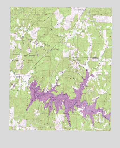
Pleasant Grove, AL USGS Topographic Map
Click on map above to begin viewing in our Map Viewer.

This topographic map contains these locations and features:
Feature Name Type Latitude Longitude GNIS ID View Map
Barker BranchStreamN34.5082°W87.9553°159114View Map
Beech Lick BranchStreamN34.5931°W87.9670°113821View Map
Big BranchStreamN34.6018°W87.9948°114238View Map
Blue Lick BranchStreamN34.5226°W87.9309°114553View Map
Blue Lick CemeteryCemeteryN34.5343°W87.9667°136127View Map
Bolton CemeteryCemeteryN34.5637°W87.8986°114705View Map
Bond CemeteryCemeteryN34.5320°W87.9520°114711View Map
Britton BranchStreamN34.5082°W87.9550°114928View Map
Burgess BridgeBridgeN34.5545°W87.9878°115223View Map
Camp BranchStreamN34.5207°W87.8995°115448View Map
Cedar Creek CemeteryCemeteryN34.5454°W87.9953°136147View Map
Cedar Creek ChurchChurchN34.5454°W87.9959°115764View Map
Cedar Creek DamDamN34.5454°W87.9750°115765View Map
Cedar Creek ReservoirReservoirN34.5291°W87.9253°132019View Map
Denton (historical)Populated PlaceN34.5856°W87.9639°132860View Map
Denton CreekStreamN34.6018°W87.9470°117233View Map
Dudley HollowValleyN34.5387°W87.9156°117626View Map
East Fork Lost CreekStreamN34.5520°W87.9073°117762View Map
Evening Shade Baptist ChurchChurchN34.5845°W87.8825°118075View Map
Ezzell Bridge (historical)BridgeN34.5207°W87.8995°141125View Map
Ezzell CemeteryCemeteryN34.5259°W87.9006°118099View Map
Ezzell FordCrossingN34.5251°W87.9059°141126View Map
Granny BranchStreamN34.5429°W87.9695°119232View Map
Greenhill CemeteryCemeteryN34.5154°W87.9028°119362View Map
Hellum Mill BranchStreamN34.5323°W87.9489°119937View Map
Hester BranchStreamN34.5512°W87.9092°120004View Map
Hub (historical)Populated PlaceN34.6098°W87.9839°132919View Map
Kimmons BranchStreamN34.5501°W87.9823°151956View Map
Liberty ChurchChurchN34.5709°W87.9170°121561View Map
Lick CreekStreamN34.5204°W87.9025°152059View Map
Little Rock CreekStreamN34.5470°W87.9775°152111View Map
Lost CreekStreamN34.5307°W87.9189°122034View Map
Massey BranchStreamN34.5318°W87.9442°122370View Map
Massey CemeteryCemeteryN34.5190°W87.9350°122371View Map
McLemore BranchStreamN34.6006°W87.9775°122586View Map
Middle Fork Lost CreekStreamN34.5565°W87.8992°152310View Map
Mint SpringsLocaleN34.5076°W87.9092°136207View Map
Mount Pleasant ChurchChurchN34.5118°W87.8898°136211View Map
Nance Store (historical)LocaleN34.5007°W87.9678°136216View Map
Oak Grove School (historical)SchoolN34.5318°W87.9584°136224View Map
Pleasant GrovePopulated PlaceN34.5715°W87.9181°156908View Map
Pleasant Grove CemeteryCemeteryN34.5706°W87.9164°136246View Map
Posey SchoolSchoolN34.5565°W87.9225°153051View Map
Punkin Center ChurchChurchN34.5556°W87.9220°153091View Map
Rock CreekPopulated PlaceN34.5968°W87.9167°156977View Map
Rock Creek Church of ChristChurchN34.5959°W87.9159°133011View Map
Rock Creek School (historical)SchoolN34.5965°W87.9153°133012View Map
Rocky BranchStreamN34.5115°W87.8784°153197View Map
Slickrock FordCrossingN34.5270°W87.9131°157075View Map
Smelser SpringSpringN34.5754°W87.9181°126981View Map
Smelser Spring BranchStreamN34.5626°W87.9056°126982View Map
Srygley Church of ChristChurchN34.5979°W87.9306°133044View Map
Taylor BranchStreamN34.5373°W87.9545°127719View Map
Thorn BridgeBridgeN34.5368°W87.9545°127919View Map
Thorn School (historical)SchoolN34.5870°W87.9664°133048View Map
Tompkins CemeteryCemeteryN34.5081°W87.9453°136296View Map
Waites Bridge (historical)BridgeN34.5184°W87.8861°141124View Map
West Fork Lost CreekStreamN34.5518°W87.9070°153941View Map
White OakPopulated PlaceN34.5476°W87.9945°157249View Map
Whiteoak School (historical)SchoolN34.5582°W87.9764°136307View Map
Wolf Den BranchStreamN34.6209°W87.9873°129167View Map

Note: Coordinates in the location and feature list above are referenced to NAD83 datum.


Copyright (C) 2008-2025 Ryan Niemi / Sunset Dynamics ... All Rights Reserved