TopoQuest Logo
Do you find TopoQuest useful?
Help keep TopoQuest running and adding new maps/features by donating!
Bitcoin:  19c7KJd3qBynnjoSw5npx9KScwjBe4ifkT
Litecoin:  LXs6TkuXGGXo1vDsWCkWVdjQX94eUKd6ui
Home View Maps Find Maps Find Places Resources & Links


Frankfort, Alabama Topographic Map

USGS Map Title: Frankfort, AL
USGS Map MRC: 34087E7
DRG (GeoTIFF) Download: o34087e7.tif


Neighboring USGS Topographic Map Quads:


  Barton, AL  
34087F8
 

  Pride, AL  
34087F7
 

  Tuscumbia, AL  
34087F6
 

  Pleasant Grove, AL  
34087E8
 

  Frankfort, AL  
34087E7
 

  Russellville, AL  
34087E6
 

  Guinn Cross Roads, AL  
34087D8
 

  Isbell, AL  
34087D7
 

  Spruce Pine, AL  
34087D6


Map MRC Location:

N35°
W88°
N35°
W87°
H8 H7 H6 H5 H4 H3 H2 H1
G8 G7 G6 G5 G4 G3 G2 G1
F8 F7 F6 F5 F4 F3 F2 F1
E8 E7 E6 E5 E4 E3 E2 E1
D8 D7 D6 D5 D4 D3 D2 D1
C8 C7 C6 C5 C4 C3 C2 C1
B8 B7 B6 B5 B4 B3 B2 B1
A8 A7 A6 A5 A4 A3 A2 A1
N34°
W88°
N34°
W87°

Frankfort, AL USGS 1:24K Topographic Map Preview:
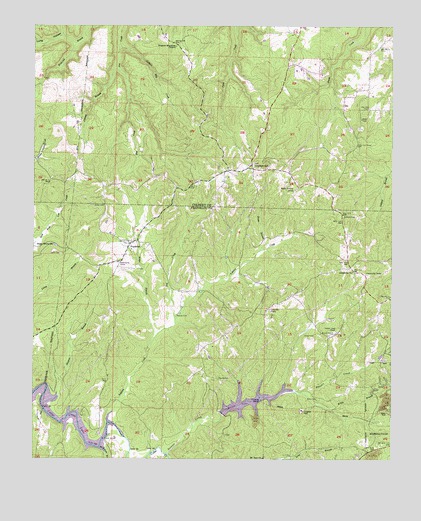
Frankfort, AL USGS Topographic Map
Click on map above to begin viewing in our Map Viewer.

This topographic map contains these locations and features:
Feature Name Type Latitude Longitude GNIS ID View Map
Antioch CemeteryCemeteryN34.5704°W87.7670°113110View Map
Burnt Church CemeteryCemeteryN34.5362°W87.7695°115264View Map
Cedar Creek Cumberland Presbyterian ChurchChurchN34.5068°W87.8295°115763View Map
Cedar Creek School (historical)SchoolN34.5240°W87.8148°136139View Map
Centerview ChurchChurchN34.5451°W87.7884°136140View Map
Charity Chapel ChurchChurchN34.6112°W87.7775°155320View Map
Crooked OakPopulated PlaceN34.5851°W87.7995°156229View Map
Crooked Oak Missionary Baptist ChurchChurchN34.5848°W87.7992°132854View Map
Crooked Oak School (historical)SchoolN34.5848°W87.8000°132855View Map
Dry CreekStreamN34.5401°W87.8259°117547View Map
Duncan CreekStreamN34.5018°W87.8289°112847View Map
Dunkin Creek Baptist ChurchChurchN34.5368°W87.7698°155394View Map
Dunkin Creek ChurchChurchN34.5270°W87.7778°117671View Map
Dunkin Creek School (historical)SchoolN34.5262°W87.7789°141122View Map
Elliott Lake DamDamN34.5134°W87.8150°132013View Map
FrankfortPopulated PlaceN34.5634°W87.8423°118592View Map
Frankfort CemeteryCemeteryN34.5643°W87.8409°136172View Map
Frankfort Junior High SchoolSchoolN34.5568°W87.8450°141103View Map
Frankfort Volunteer Fire DepartmentBuildingN34.5625°W87.8402°2683150View Map
Hester BranchStreamN34.5606°W87.7950°120005View Map
Hester BridgeBridgeN34.5059°W87.8503°120007View Map
Hester CemeteryCemeteryN34.5070°W87.8078°136181View Map
Hovaters Mill (historical)LocaleN34.5484°W87.8175°141123View Map
Jackson Mill CreekStreamN34.6187°W87.8456°120778View Map
Jimmie BranchStreamN34.6126°W87.8467°120894View Map
Jones CemeteryCemeteryN34.5359°W87.7767°120993View Map
Jones CemeteryCemeteryN34.5737°W87.8506°151911View Map
JonesboroPopulated PlaceN34.5556°W87.7631°136189View Map
Jonesboro Baptist ChurchChurchN34.5545°W87.7636°151921View Map
Jonesboro CemeteryCemeteryN34.5551°W87.7631°136190View Map
Jonesboro Community CenterBuildingN34.5551°W87.7634°136191View Map
Jonesboro School (historical)SchoolN34.5537°W87.7631°136192View Map
Lime Rock SchoolSchoolN34.6045°W87.7584°121637View Map
Limerock ChurchChurchN34.6015°W87.7603°155322View Map
Little Israel Christian RanchLocaleN34.6115°W87.7750°132945View Map
Long HollowValleyN34.6198°W87.8614°122010View Map
Malone CemeteryCemeteryN34.5418°W87.8253°122233View Map
McKnight BranchStreamN34.5034°W87.8517°122580View Map
Mickins BranchStreamN34.5176°W87.8720°152307View Map
Miller BranchStreamN34.5320°W87.8353°122818View Map
Mount Zion ChurchChurchN34.5007°W87.7939°152537View Map
Mount Zion School (historical)SchoolN34.5009°W87.7942°136212View Map
Russellville ReservoirReservoirN34.5170°W87.7990°153232View Map
Sand Lick (historical)Populated PlaceN34.5973°W87.7936°166028View Map
Sand Lick Post Office (historical)Post OfficeN34.5973°W87.7936°169307View Map
Shady Grove CemeteryCemeteryN34.5615°W87.8675°136273View Map
Shady Grove Church of ChristChurchN34.5620°W87.8678°153395View Map
Slosh DamDamN34.5334°W87.7500°132015View Map
Slosh LakeReservoirN34.5334°W87.7500°132016View Map
Sparks CemeteryCemeteryN34.5234°W87.8109°127167View Map
Taylor CemeteryCemeteryN34.5595°W87.8656°127731View Map
Tollison CreekStreamN34.5107°W87.8486°128010View Map
Wagnon Mountain ChurchChurchN34.6190°W87.8261°128497View Map
Waterfall Valley Conservation ClubLocaleN34.5945°W87.8181°133065View Map
WFIQ-TV (Florence)TowerN34.5779°W87.7817°161271View Map
Willis BranchStreamN34.5193°W87.7814°129045View Map
Willis CemeteryCemeteryN34.5173°W87.7756°129047View Map
WOWL-TV (Florence)TowerN34.5837°W87.7873°161272View Map
WTUK-TV (Florence)TowerN34.5873°W87.7875°161273View Map

Note: Coordinates in the location and feature list above are referenced to NAD83 datum.


Copyright (C) 2008-2025 Ryan Niemi / Sunset Dynamics ... All Rights Reserved