TopoQuest Logo
Do you find TopoQuest useful?
Help keep TopoQuest running and adding new maps/features by donating!
Bitcoin:  19c7KJd3qBynnjoSw5npx9KScwjBe4ifkT
Litecoin:  LXs6TkuXGGXo1vDsWCkWVdjQX94eUKd6ui
Home View Maps Find Maps Find Places Resources & Links


Priest Valley, California Topographic Map

USGS Map Title: Priest Valley, CA
USGS Map MRC: 36120B6
DRG (GeoTIFF) Download: o36120b6.tif


Neighboring USGS Topographic Map Quads:


  Hepsedam Peak, CA  
36120C7
 

  San Benito Mountain, CA  
36120C6
 

  Santa Rita Peak, CA  
36120C5
 

  Monarch Peak, CA  
36120B7
 

  Priest Valley, CA  
36120B6
 

  Sherman Peak, CA  
36120B5
 

  Pancho Rico Valley, CA  
36120A7
 

  Slack Canyon, CA  
36120A6
 

  Smith Mountain, CA  
36120A5


Map MRC Location:

N37°
W121°
N37°
W120°
H8 H7 H6 H5 H4 H3 H2 H1
G8 G7 G6 G5 G4 G3 G2 G1
F8 F7 F6 F5 F4 F3 F2 F1
E8 E7 E6 E5 E4 E3 E2 E1
D8 D7 D6 D5 D4 D3 D2 D1
C8 C7 C6 C5 C4 C3 C2 C1
B8 B7 B6 B5 B4 B3 B2 B1
A8 A7 A6 A5 A4 A3 A2 A1
N36°
W121°
N36°
W120°

Priest Valley, CA USGS 1:24K Topographic Map Preview:
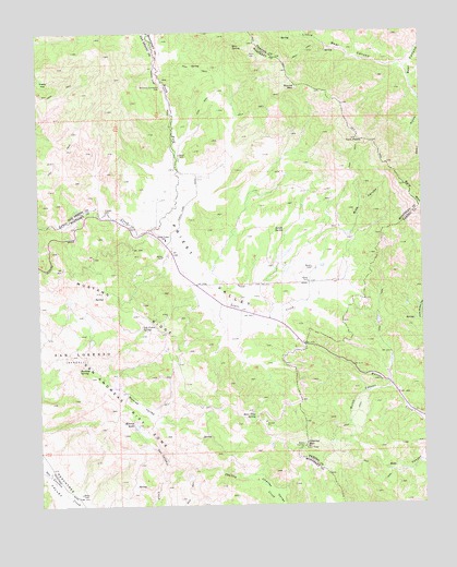
Priest Valley, CA USGS Topographic Map
Click on map above to begin viewing in our Map Viewer.

This topographic map contains these locations and features:
Feature Name Type Latitude Longitude GNIS ID View Map
Bear CanyonValleyN36.2458°W120.6260°239084View Map
Bear SpringSpringN36.2466°W120.6865°239109View Map
Bear Trap SpringSpringN36.1476°W120.6816°239112View Map
Blue CanyonValleyN36.1922°W120.6579°239492View Map
Buckeye SpringSpringN36.1620°W120.7379°239770View Map
Charley CreekStreamN36.1325°W120.7116°240484View Map
Charley MountainSummitN36.1402°W120.6652°240485View Map
Charley ValleyBasinN36.1264°W120.6593°240486View Map
Clayton CemeteryCemeteryN36.2026°W120.7295°240677View Map
Indian SpringSpringN36.1979°W120.6705°243840View Map
Little Bear CanyonValleyN36.2411°W120.6324°244895View Map
Log Cabin SpringSpringN36.1725°W120.7176°245005View Map
Monroe LakeLakeN36.1463°W120.7201°246086View Map
Monroe ValleyBasinN36.1519°W120.7191°246094View Map
Mulch CanyonValleyN36.1555°W120.6374°246347View Map
North Fork Lewis CreekStreamN36.1980°W120.7152°246613View Map
Pretty FlatFlatN36.2377°W120.7491°247777View Map
Priest ValleyBasinN36.1869°W120.7002°247783View Map
Priest Valley SchoolSchoolN36.1952°W120.7102°247784View Map
Round MountainSummitN36.2350°W120.6696°1661341View Map
Twin PeaksSummitN36.2216°W120.6468°250749View Map
Williams-Duckworth CemeteryCemeteryN36.2356°W120.7101°251605View Map

Note: Coordinates in the location and feature list above are referenced to NAD83 datum.


Copyright (C) 2008-2024 Ryan Niemi / Sunset Dynamics ... All Rights Reserved