TopoQuest Logo
Do you find TopoQuest useful?
Help keep TopoQuest running and adding new maps/features by donating!
Bitcoin:  19c7KJd3qBynnjoSw5npx9KScwjBe4ifkT
Litecoin:  LXs6TkuXGGXo1vDsWCkWVdjQX94eUKd6ui
Home View Maps Find Maps Find Places Resources & Links


Pringletown, South Carolina Topographic Map

USGS Map Title: Pringletown, SC
USGS Map MRC: 33080B3
DRG (GeoTIFF) Download: o33080b3.tif


Neighboring USGS Topographic Map Quads:


  Holly Hill, SC  
33080C4
 

  Sandridge, SC  
33080C3
 

  Cross, SC  
33080C2
 

  Harleyville, SC  
33080B4
 

  Pringletown, SC  
33080B3
 

  Summerville NW, SC  
33080B2
 

  Maple Cane Swamp, SC  
33080A4
 

  Ridgeville, SC  
33080A3
 

  Summerville, SC  
33080A2


Map MRC Location:

N34°
W81°
N34°
W80°
H8 H7 H6 H5 H4 H3 H2 H1
G8 G7 G6 G5 G4 G3 G2 G1
F8 F7 F6 F5 F4 F3 F2 F1
E8 E7 E6 E5 E4 E3 E2 E1
D8 D7 D6 D5 D4 D3 D2 D1
C8 C7 C6 C5 C4 C3 C2 C1
B8 B7 B6 B5 B4 B3 B2 B1
A8 A7 A6 A5 A4 A3 A2 A1
N33°
W81°
N33°
W80°

Pringletown, SC USGS 1:24K Topographic Map Preview:
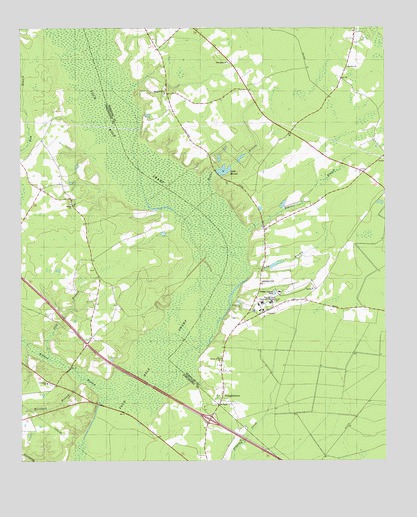
Pringletown, SC USGS Topographic Map
Click on map above to begin viewing in our Map Viewer.

This topographic map contains these locations and features:
Feature Name Type Latitude Longitude GNIS ID View Map
Bethel ChurchChurchN33.1993°W80.3576°1220551View Map
Deep BranchStreamN33.1543°W80.3651°1221969View Map
Elmore School (historical)SchoolN33.1846°W80.3540°1241093View Map
Four Hole BridgeBridgeN33.1416°W80.3484°1241102View Map
Four Hole Bridge Revolutionary PostLocaleN33.1410°W80.3479°1241103View Map
Four Hole School (historical)SchoolN33.1710°W80.2848°1234304View Map
Hope (historical)Populated PlaceN33.2238°W80.2901°1234319View Map
Hope Graded School (historical)SchoolN33.2263°W80.2920°1234320View Map
House of God ChurchChurchN33.1546°W80.3062°1246080View Map
Interchange 187CrossingN33.1371°W80.3104°1228222View Map
Lake MerkelReservoirN33.2089°W80.3051°1224454View Map
Limestone CemeteryCemeteryN33.1474°W80.3648°1248784View Map
Limestone ChurchChurchN33.1477°W80.3659°1246371View Map
MacDougall Correctional InstitutionBuildingN33.1685°W80.2949°1224237View Map
Marshall BranchStreamN33.1485°W80.3545°1224332View Map
Merkel BranchStreamN33.1904°W80.3093°1224453View Map
Mims Lake CemeteryCemeteryN33.1699°W80.3009°1234338View Map
Mizell School (historical)SchoolN33.1835°W80.3504°1241147View Map
Mount PisgahPopulated PlaceN33.1413°W80.3070°1234345View Map
Mount Pisgah ChurchChurchN33.1413°W80.3076°1224763View Map
Mount Zion ChurchChurchN33.2388°W80.2629°1224819View Map
Mudville School (historical)SchoolN33.2088°W80.2576°1234349View Map
Pisgah School (historical)SchoolN33.1543°W80.3062°1252150View Map
PringletownPopulated PlaceN33.1438°W80.3059°1250248View Map
Rock BranchStreamN33.1807°W80.2965°1225920View Map
Sandridge Baptist ChurchChurchN33.2402°W80.3040°1250755View Map
Sandridge CemeteryCemeteryN33.2399°W80.3031°1234389View Map
Sandridge Fire Department Company 11BuildingN33.2412°W80.3042°2368355View Map
Sandridge Fire Department Pringletown StationBuildingN33.1613°W80.3031°2368222View Map
Santee BranchStreamN33.1913°W80.2970°1226394View Map
South Carolina Noname 08021 D-3463 DamDamN33.2091°W80.3084°1238710View Map
South Carolina Noname 08027 D-3464 DamDamN33.1902°W80.2898°1238716View Map
Spring HillPopulated PlaceN33.2313°W80.3245°1234393View Map
Spring Hill ChurchChurchN33.2313°W80.3259°1251003View Map
Springhill CemeteryCemeteryN33.2310°W80.3254°1234395View Map
Tupelo BayBasinN33.2404°W80.2818°1234404View Map
Walnut BranchStreamN33.1457°W80.3429°1227384View Map

Note: Coordinates in the location and feature list above are referenced to NAD83 datum.


Copyright (C) 2008-2024 Ryan Niemi / Sunset Dynamics ... All Rights Reserved