TopoQuest Logo
Do you find TopoQuest useful?
Help keep TopoQuest running and adding new maps/features by donating!
Bitcoin:  19c7KJd3qBynnjoSw5npx9KScwjBe4ifkT
Litecoin:  LXs6TkuXGGXo1vDsWCkWVdjQX94eUKd6ui
Home View Maps Find Maps Find Places Resources & Links


Providence, Kentucky Topographic Map

USGS Map Title: Providence, KY
USGS Map MRC: 37087D7
DRG (GeoTIFF) Download: o37087d7.tif


Neighboring USGS Topographic Map Quads:


  Sturgis, KY  
37087E8
 

  Bordley, KY  
37087E7
 

  Dixon, KY  
37087E6
 

  Blackford, KY  
37087D8
 

  Providence, KY  
37087D7
 

  Nebo, KY  
37087D6
 

  Shady Grove, KY  
37087C8
 

  Dalton, KY  
37087C7
 

  Coiltown, KY  
37087C6


Map MRC Location:

N38°
W88°
N38°
W87°
H8 H7 H6 H5 H4 H3 H2 H1
G8 G7 G6 G5 G4 G3 G2 G1
F8 F7 F6 F5 F4 F3 F2 F1
E8 E7 E6 E5 E4 E3 E2 E1
D8 D7 D6 D5 D4 D3 D2 D1
C8 C7 C6 C5 C4 C3 C2 C1
B8 B7 B6 B5 B4 B3 B2 B1
A8 A7 A6 A5 A4 A3 A2 A1
N37°
W88°
N37°
W87°

Providence, KY USGS 1:24K Topographic Map Preview:
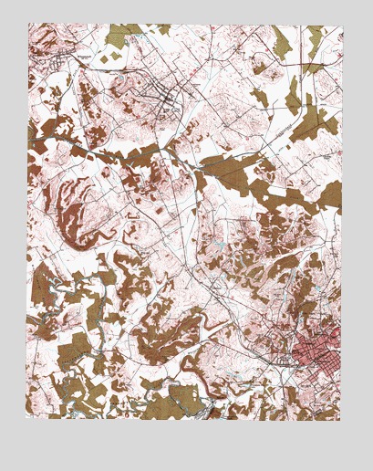
Providence, KY USGS Topographic Map
Click on map above to begin viewing in our Map Viewer.

This topographic map contains these locations and features:
Feature Name Type Latitude Longitude GNIS ID View Map
Bald HillSummitN37.4045°W87.8589°486259View Map
BellvillePopulated PlaceN37.3817°W87.7992°507491View Map
Big Hill CemeteryCemeteryN37.4033°W87.7610°487184View Map
Blackwell CemeteryCemeteryN37.4710°W87.8231°487426View Map
Caney ForkStreamN37.4637°W87.8667°488863View Map
Cedar Street High SchoolSchoolN37.3967°W87.7661°489250View Map
City of ClayCivilN37.4763°W87.8203°2404064View Map
City of ProvidenceCivilN37.3993°W87.7509°2404576View Map
City of WheatcroftCivilN37.4893°W87.8612°2405725View Map
Clark DitchCanalN37.4667°W87.7725°489538View Map
ClayPopulated PlaceN37.4767°W87.8200°489565View Map
Clay DivisionCivilN37.4810°W87.8509°1936935View Map
Clay Fire DepartmentBuildingN37.4771°W87.8205°2637066View Map
Clay Police DepartmentBuildingN37.4771°W87.8204°2767669View Map
Clifty HillSummitN37.4489°W87.8128°489687View Map
Clifty MineMineN37.4523°W87.8111°489690View Map
Cullen CemeteryCemeteryN37.4140°W87.7751°490464View Map
Cumberland ChurchChurchN37.3967°W87.7589°490472View Map
DiamondPopulated PlaceN37.4167°W87.8022°490858View Map
Diamond MinesMineN37.4217°W87.7964°490864View Map
Dorris CemeteryCemeteryN37.4020°W87.7704°491003View Map
Douven MineMineN37.4145°W87.7572°491065View Map
Elm Grove ChurchChurchN37.4275°W87.7528°491730View Map
FairmontPopulated PlaceN37.4600°W87.8500°507970View Map
Fairmont MinesMineN37.4637°W87.8495°491886View Map
Fraser - Blackwell CemeteryCemeteryN37.4393°W87.8167°492472View Map
Fredricks ChapelChurchN37.4587°W87.7575°492489View Map
Fredricks DitchCanalN37.4589°W87.7770°492490View Map
Green Grove ChurchChurchN37.3992°W87.8078°493270View Map
Green Grove HillSummitN37.3989°W87.8175°493271View Map
I N Baker DitchCanalN37.4459°W87.7728°494874View Map
Johnson CemeteryCemeteryN37.4009°W87.8720°495379View Map
Johnson CemeteryCemeteryN37.4317°W87.7889°495380View Map
Johnson MinesMineN37.4345°W87.8617°495422View Map
Lanaham MineMineN37.4284°W87.8539°495945View Map
Mine Number 10MineN37.4745°W87.8534°517240View Map
Mine Number 4MineN37.4859°W87.8675°517241View Map
Mine Number 5MineN37.4839°W87.8395°517242View Map
Montezuma BridgeBridgeN37.3967°W87.8447°498497View Map
Montezuma MineMineN37.3942°W87.8183°498498View Map
Mount Olivet (historical)Populated PlaceN37.4108°W87.8534°2743696View Map
Nesbit HillSummitN37.4481°W87.8228°499267View Map
New Hopewell ChurchChurchN37.4403°W87.8639°499363View Map
Odd Fellows CemeteryCemeteryN37.4795°W87.8104°499770View Map
Owens CreekStreamN37.3787°W87.8008°500073View Map
Pleasant Hill ChurchChurchN37.4017°W87.7550°500866View Map
ProvidencePopulated PlaceN37.3975°W87.7628°501368View Map
Providence City LakeReservoirN37.3862°W87.7875°501380View Map
Providence DivisionCivilN37.4259°W87.7619°1937212View Map
Providence Fire DepartmentBuildingN37.3992°W87.7616°2636513View Map
Providence Police DepartmentBuildingN37.3993°W87.7611°2767499View Map
Rock Springs CemeteryCemeteryN37.4936°W87.8745°499321View Map
Rosenwald SchoolSchoolN37.4025°W87.7553°502352View Map
Shaft Number 7MineN37.4945°W87.8325°517281View Map
Slover CreekStreamN37.4548°W87.8072°503714View Map
South Broadway SchoolSchoolN37.3931°W87.7595°503894View Map
Tigg MineMineN37.4037°W87.8300°505276View Map
Tulno MineMineN37.4320°W87.8033°505563View Map
Union ChurchChurchN37.4020°W87.7803°505782View Map
Vaughn MineMineN37.4423°W87.8670°505999View Map
Victory ChurchChurchN37.3923°W87.7583°506043View Map
W L Baker DitchCanalN37.4573°W87.8345°506076View Map
West WheatcroftPopulated PlaceN37.4881°W87.8711°506483View Map
WheatcroftPopulated PlaceN37.4900°W87.8628°506516View Map
Wheatcroft Fire DepartmentBuildingN37.4894°W87.8627°2637064View Map
White Oak ChurchChurchN37.4284°W87.8295°506606View Map
Whiteside CreekStreamN37.3875°W87.8172°506680View Map
WHRZ-FM (Providence)TowerN37.4098°W87.7756°518014View Map
Williams CemeteryCemeteryN37.3870°W87.8717°506800View Map
Wolf CreekStreamN37.3778°W87.8553°506998View Map
Wynn CemeteryCemeteryN37.3979°W87.8269°507181View Map

Note: Coordinates in the location and feature list above are referenced to NAD83 datum.


Copyright (C) 2008-2024 Ryan Niemi / Sunset Dynamics ... All Rights Reserved