TopoQuest Logo
Do you find TopoQuest useful?
Help keep TopoQuest running and adding new maps/features by donating!
Bitcoin:  19c7KJd3qBynnjoSw5npx9KScwjBe4ifkT
Litecoin:  LXs6TkuXGGXo1vDsWCkWVdjQX94eUKd6ui
Home View Maps Find Maps Find Places Resources & Links


Shady Grove, Kentucky Topographic Map

USGS Map Title: Shady Grove, KY
USGS Map MRC: 37087C8
DRG (GeoTIFF) Download: o37087c8.tif


Neighboring USGS Topographic Map Quads:


  Repton, KY  
37088D1
 

  Blackford, KY  
37087D8
 

  Providence, KY  
37087D7
 

  Marion, KY  
37088C1
 

  Shady Grove, KY  
37087C8
 

  Dalton, KY  
37087C7
 

  Fredonia, KY  
37088B1
 

  Crider, KY  
37087B8
 

  Olney, KY  
37087B7


Map MRC Location:

N38°
W88°
N38°
W87°
H8 H7 H6 H5 H4 H3 H2 H1
G8 G7 G6 G5 G4 G3 G2 G1
F8 F7 F6 F5 F4 F3 F2 F1
E8 E7 E6 E5 E4 E3 E2 E1
D8 D7 D6 D5 D4 D3 D2 D1
C8 C7 C6 C5 C4 C3 C2 C1
B8 B7 B6 B5 B4 B3 B2 B1
A8 A7 A6 A5 A4 A3 A2 A1
N37°
W88°
N37°
W87°

Shady Grove, KY USGS 1:24K Topographic Map Preview:
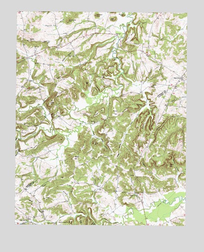
Shady Grove, KY USGS Topographic Map
Click on map above to begin viewing in our Map Viewer.

This topographic map contains these locations and features:
Feature Name Type Latitude Longitude GNIS ID View Map
Alexander CreekStreamN37.3003°W87.9964°485828View Map
Bellers HollowValleyN37.3451°W87.9655°486808View Map
Bevens BranchStreamN37.3103°W87.9511°487057View Map
Blackburn (historical)Populated PlaceN37.3100°W87.9417°2743662View Map
Blackburn ChurchChurchN37.3103°W87.9411°487403View Map
Bottom KnobSummitN37.3734°W87.9211°487721View Map
Buggs BranchStreamN37.3020°W87.9628°488339View Map
Butler CreekStreamN37.3056°W87.9736°488513View Map
Buzzard HollowValleyN37.2554°W87.9504°488534View Map
Buzzard Roost BluffCliffN37.3567°W87.9778°488548View Map
Carney CemeteryCemeteryN37.2795°W87.9122°488950View Map
Coolers KnobSummitN37.2853°W87.8872°490022View Map
Copperus SpringSpringN37.3340°W87.9907°490088View Map
Corley HillSummitN37.3212°W87.9747°490112View Map
Crayne HillSummitN37.2981°W87.9489°490312View Map
CreswellPopulated PlaceN37.2687°W87.9122°507782View Map
Creswell Baptist ChurchChurchN37.2675°W87.9117°490337View Map
Creswell BranchStreamN37.2609°W87.9006°490336View Map
Dean BranchStreamN37.3645°W87.9216°490737View Map
DeanwoodPopulated PlaceN37.3614°W87.9264°507828View Map
EnonPopulated PlaceN37.2537°W87.9900°507943View Map
Felker HillSummitN37.2653°W87.9775°492021View Map
Flat Rock BranchStreamN37.2514°W87.9700°492205View Map
Fort SpringSpringN37.2514°W87.9622°2743597View Map
Fralick CemeteryCemeteryN37.2778°W87.9639°492428View Map
Fralick HollowValleyN37.3023°W87.9427°492429View Map
Frog HollowValleyN37.2982°W87.9224°492565View Map
GibralterSummitN37.3423°W87.9309°492801View Map
Gilliland HillSummitN37.2887°W87.9578°492848View Map
Gosche HollowValleyN37.2516°W87.9418°493037View Map
Graveyard KnobSummitN37.3728°W87.9409°493188View Map
Gum CreekStreamN37.3317°W87.9111°493481View Map
Haw RidgeRidgeN37.2720°W87.9636°493878View Map
Hillyard BranchStreamN37.2556°W87.9547°494286View Map
Hogbed HollowValleyN37.2800°W87.8980°494358View Map
Hornin HollowValleyN37.2812°W87.8806°494564View Map
Little Piney CreekStreamN37.3389°W87.9225°496826View Map
Lowery CemeteryCemeteryN37.2695°W87.9183°497317View Map
McCain HillSummitN37.3162°W87.9264°497767View Map
McChesney HillSummitN37.3173°W87.9183°497781View Map
Mills KnobSummitN37.3709°W87.9281°498377View Map
Olive BranchStreamN37.3652°W87.9375°499917View Map
Olive Branch CemeteryCemeteryN37.3614°W87.9617°499919View Map
Orr BranchStreamN37.2600°W87.9147°500001View Map
Paley HillSummitN37.3364°W87.9664°500137View Map
Pickens CemeteryCemeteryN37.3639°W87.9947°500556View Map
Pickens HillSummitN37.3581°W87.9909°500557View Map
Pickens SpringSpringN37.3543°W87.9865°500558View Map
Pine BluffCliffN37.2570°W87.9517°500666View Map
Pine Knob BluffCliffN37.3134°W87.9731°500705View Map
Piney BluffCliffN37.3606°W87.9184°500727View Map
Pleasant Hill CemeteryCemeteryN37.2712°W87.9364°500843View Map
Polk HillSummitN37.3331°W87.9489°501004View Map
Riffle HillSummitN37.2975°W87.9820°501853View Map
Schoolhouse KnobSummitN37.3689°W87.9625°503065View Map
Shady GrovePopulated PlaceN37.3367°W87.8792°503209View Map
Shady Grove Volunteer Fire DepartmentBuildingN37.3374°W87.8787°2636942View Map
Sigler HollowValleyN37.3189°W87.9024°503490View Map
Spring BranchStreamN37.2517°W87.9778°504102View Map
Stopping RocksSummitN37.3470°W87.9284°504524View Map
Sugar CreekStreamN37.3603°W87.9217°504649View Map
Sugar Grove ChurchChurchN37.3495°W87.9570°504662View Map
The PinnaclePillarN37.2514°W87.9622°505140View Map
Tom O'Neal HollowValleyN37.3689°W87.9164°505337View Map
Towery CemeteryCemeteryN37.2909°W87.9000°505372View Map
Travis CemeteryCemeteryN37.3059°W87.9895°505478View Map
TribunePopulated PlaceN37.3478°W87.9920°509233View Map
Tribune CreekStreamN37.3189°W87.9809°505492View Map
Turkey HillSummitN37.3167°W87.9384°505611View Map
Turley HollowValleyN37.3273°W87.9391°505644View Map
Turnip HillSummitN37.2978°W87.9420°505675View Map
Walnut Grove Missionary Baptist ChurchChurchN37.2525°W87.9908°506173View Map
West Fork Donaldson CreekStreamN37.2506°W87.9206°506430View Map
Wilson CemeteryCemeteryN37.3042°W87.9956°506887View Map

Note: Coordinates in the location and feature list above are referenced to NAD83 datum.


Copyright (C) 2008-2024 Ryan Niemi / Sunset Dynamics ... All Rights Reserved