TopoQuest Logo
Do you find TopoQuest useful?
Help keep TopoQuest running and adding new maps/features by donating!
Bitcoin:  19c7KJd3qBynnjoSw5npx9KScwjBe4ifkT
Litecoin:  LXs6TkuXGGXo1vDsWCkWVdjQX94eUKd6ui
Home View Maps Find Maps Find Places Resources & Links


Blackford, Kentucky Topographic Map

USGS Map Title: Blackford, KY
USGS Map MRC: 37087D8
DRG (GeoTIFF) Download: o37087d8.tif


Neighboring USGS Topographic Map Quads:


  Dekoven, KY  
37088E1
 

  Sturgis, KY  
37087E8
 

  Bordley, KY  
37087E7
 

  Repton, KY  
37088D1
 

  Blackford, KY  
37087D8
 

  Providence, KY  
37087D7
 

  Marion, KY  
37088C1
 

  Shady Grove, KY  
37087C8
 

  Dalton, KY  
37087C7


Map MRC Location:

N38°
W88°
N38°
W87°
H8 H7 H6 H5 H4 H3 H2 H1
G8 G7 G6 G5 G4 G3 G2 G1
F8 F7 F6 F5 F4 F3 F2 F1
E8 E7 E6 E5 E4 E3 E2 E1
D8 D7 D6 D5 D4 D3 D2 D1
C8 C7 C6 C5 C4 C3 C2 C1
B8 B7 B6 B5 B4 B3 B2 B1
A8 A7 A6 A5 A4 A3 A2 A1
N37°
W88°
N37°
W87°

Blackford, KY USGS 1:24K Topographic Map Preview:
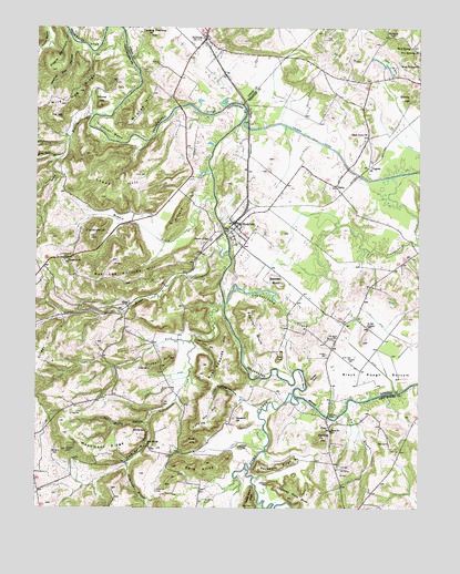
Blackford, KY USGS Topographic Map
Click on map above to begin viewing in our Map Viewer.

This topographic map contains these locations and features:
Feature Name Type Latitude Longitude GNIS ID View Map
Arflack HillSummitN37.4489°W87.9553°486022View Map
Babb CemeteryCemeteryN37.3923°W87.8850°486169View Map
Backbone RidgeRidgeN37.3859°W87.9206°486188View Map
Bald AlleyRidgeN37.3867°W87.9428°486254View Map
Big BranchStreamN37.4000°W87.8989°487136View Map
Black Grove ChurchChurchN37.4725°W87.8922°487363View Map
Black Rough BottomBendN37.4081°W87.8900°487385View Map
BlackfordPopulated PlaceN37.4484°W87.9347°487410View Map
Blackford Fire DepartmentBuildingN37.4457°W87.9307°2637069View Map
Bob Edwards HillSummitN37.4158°W87.9395°2743664View Map
Bob Lee Phillips HillSummitN37.4356°W87.9781°487603View Map
Brantley BluffCliffN37.4081°W87.9092°487838View Map
Caney ForkStreamN37.4187°W87.9492°488852View Map
Carding Machine HillSummitN37.4987°W87.9622°488930View Map
Cave Spring ChurchChurchN37.3917°W87.9636°489137View Map
Cave Spring HollowValleyN37.3969°W87.9629°489140View Map
Cave Springs (historical)Populated PlaceN37.3913°W87.9638°2743665View Map
Chimney RockPillarN37.3817°W87.9234°489477View Map
Chimney Rock BluffCliffN37.3787°W87.9189°489478View Map
Church of GodChurchN37.4448°W87.9434°489512View Map
Cool Spring HollowValleyN37.4043°W87.9337°490020View Map
Cottonpatch HillSummitN37.4459°W87.9820°490151View Map
Craborchard CreekStreamN37.4284°W87.9384°490248View Map
Crider HillSummitN37.4148°W87.9995°511637View Map
Crowell CemeteryCemeteryN37.4114°W87.9625°490414View Map
Crowell HillSummitN37.4139°W87.9561°490415View Map
DerbyPopulated PlaceN37.4592°W87.9025°507849View Map
East Crittenden DivisionCivilN37.3808°W87.9822°1936958View Map
Enon ChurchChurchN37.3953°W87.9036°491790View Map
FishtrapPopulated PlaceN37.3923°W87.9039°2743686View Map
Fishtrap BridgeBridgeN37.3992°W87.9047°492137View Map
Fishtrap HillSummitN37.3937°W87.9059°492140View Map
Fox HillSummitN37.4770°W87.9959°492409View Map
Gilchrist BendBendN37.4723°W87.9759°492825View Map
Gobblers KnobSummitN37.4331°W87.9206°492928View Map
Gopher Den HollowValleyN37.4939°W87.9875°493028View Map
Granny HillSummitN37.4820°W87.8778°493112View Map
Heath MountainSummitN37.4889°W87.9950°493982View Map
Hoods CreekStreamN37.4417°W87.9372°512766View Map
Horseshoe BendBendN37.4078°W87.9128°494602View Map
Iron HillSummitN37.3885°W87.9559°2743692View Map
Kelly Orr HillSummitN37.3925°W87.9489°495632View Map
Kilpatrick BranchStreamN37.3864°W87.9700°495727View Map
Kilpatrick CemeteryCemeteryN37.3795°W87.9600°495728View Map
King CemeteryCemeteryN37.3995°W87.9883°495739View Map
Long BranchStreamN37.4770°W87.9817°513607View Map
McGraw HillSummitN37.4753°W87.9697°497871View Map
Meadow CreekStreamN37.4559°W87.9420°497980View Map
Middle KnobSummitN37.3925°W87.9489°498144View Map
Monument RidgeRidgeN37.3906°W87.9761°498518View Map
New Harmony ChurchChurchN37.4939°W87.8750°499327View Map
NunnPopulated PlaceN37.4275°W87.9700°508725View Map
Nunn CemeteryCemeteryN37.4617°W87.9678°499637View Map
Oak Grove CemeteryCemeteryN37.4191°W87.9032°499662View Map
Pat Duffy HollowValleyN37.3969°W87.9637°500233View Map
Peter Cave BluffCliffN37.3806°W87.9292°500461View Map
Pigeonroost CreekStreamN37.4287°W87.9386°500604View Map
PineyPopulated PlaceN37.3964°W87.9039°508825View Map
Piney CreekStreamN37.4048°W87.9159°500729View Map
Popular BluffCliffN37.4209°W87.9328°501138View Map
Rock SpringPopulated PlaceN37.4950°W87.8775°508954View Map
Rosebud (historical)Populated PlaceN37.4396°W87.9904°2743701View Map
Rosebud ChurchChurchN37.4389°W87.9900°502346View Map
Rosebud HillSummitN37.4412°W87.9904°2743702View Map
Round HillSummitN37.4800°W87.9800°502400View Map
Sand Cave BranchStreamN37.4656°W87.9936°515212View Map
Sharp ShinRidgeN37.4184°W87.9472°503261View Map
Snead HillSummitN37.4589°W87.9731°503848View Map
Springfield HillSummitN37.3978°W87.9350°504159View Map
SullivanPopulated PlaceN37.4975°W87.9453°504720View Map
Tater HillSummitN37.3912°W87.9325°504974View Map
Tosh CemeteryCemeteryN37.4025°W87.9583°505366View Map
Tudor BluffCliffN37.4134°W87.9211°505551View Map
Vaughn DitchCanalN37.4667°W87.9011°505996View Map
VirginiaPopulated PlaceN37.4639°W87.8917°509294View Map
Wild Hog RidgeRidgeN37.4823°W87.9878°506723View Map

Note: Coordinates in the location and feature list above are referenced to NAD83 datum.


Copyright (C) 2008-2025 Ryan Niemi / Sunset Dynamics ... All Rights Reserved