TopoQuest Logo
Do you find TopoQuest useful?
Help keep TopoQuest running and adding new maps/features by donating!
Bitcoin:  19c7KJd3qBynnjoSw5npx9KScwjBe4ifkT
Litecoin:  LXs6TkuXGGXo1vDsWCkWVdjQX94eUKd6ui
Home View Maps Find Maps Find Places Resources & Links


Sturgis, Kentucky Topographic Map

USGS Map Title: Sturgis, KY
USGS Map MRC: 37087E8
DRG (GeoTIFF) Download: o37087e8.tif


Neighboring USGS Topographic Map Quads:


  Grove Center, KY  
37088F1
 

  Morganfield, KY  
37087F8
 

  Waverly, KY  
37087F7
 

  Dekoven, KY  
37088E1
 

  Sturgis, KY  
37087E8
 

  Bordley, KY  
37087E7
 

  Repton, KY  
37088D1
 

  Blackford, KY  
37087D8
 

  Providence, KY  
37087D7


Map MRC Location:

N38°
W88°
N38°
W87°
H8 H7 H6 H5 H4 H3 H2 H1
G8 G7 G6 G5 G4 G3 G2 G1
F8 F7 F6 F5 F4 F3 F2 F1
E8 E7 E6 E5 E4 E3 E2 E1
D8 D7 D6 D5 D4 D3 D2 D1
C8 C7 C6 C5 C4 C3 C2 C1
B8 B7 B6 B5 B4 B3 B2 B1
A8 A7 A6 A5 A4 A3 A2 A1
N37°
W88°
N37°
W87°

Sturgis, KY USGS 1:24K Topographic Map Preview:
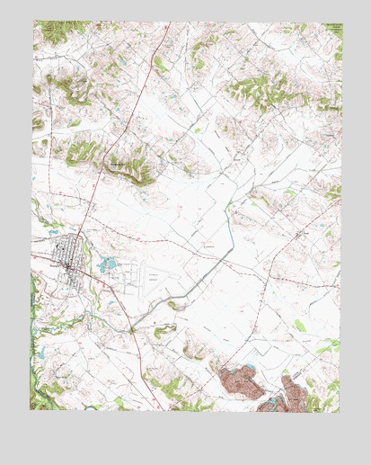
Sturgis, KY USGS Topographic Map
Click on map above to begin viewing in our Map Viewer.

This topographic map contains these locations and features:
Feature Name Type Latitude Longitude GNIS ID View Map
Adamson BranchStreamN37.5028°W87.9917°510218View Map
ArnoldPopulated PlaceN37.5812°W87.9181°507415View Map
Bethany ChurchChurchN37.5531°W87.9297°486935View Map
Bethel CemeteryCemeteryN37.6064°W87.9806°486952View Map
Bishop DitchCanalN37.5250°W87.8847°487347View Map
Blueberry HillSummitN37.5792°W87.9684°487559View Map
Bordley DitchCanalN37.5367°W87.8836°487708View Map
City of SturgisCivilN37.5465°W87.9878°2405536View Map
Corbett DitchCanalN37.5800°W87.8995°490090View Map
CullenPopulated PlaceN37.5895°W87.8781°507792View Map
Cypress CreekStreamN37.5245°W87.9995°490527View Map
Dyson CreekStreamN37.5670°W87.9195°491399View Map
Eberly (historical)Populated PlaceN37.5407°W87.9045°2743572View Map
HazelPopulated PlaceN37.5123°W87.9895°508211View Map
Hazel BranchStreamN37.5259°W87.9600°493946View Map
Holeman HillSummitN37.5989°W87.8784°494387View Map
Hopgood DitchCanalN37.5787°W87.9231°494541View Map
Hudson HillSummitN37.5012°W87.8859°494726View Map
Kern OrchardPopulated PlaceN37.5767°W87.9717°2743583View Map
Mount Gilead CemeteryCemeteryN37.6181°W87.9300°498729View Map
Mount Pleasant CemeteryCemeteryN37.5139°W87.9525°498825View Map
PridePopulated PlaceN37.5584°W87.8909°501341View Map
Pythian Ridge CemeteryCemeteryN37.5572°W87.9780°501473View Map
Salem CemeteryCemeteryN37.6175°W87.9467°502773View Map
ShrotePopulated PlaceN37.6238°W87.9448°2743591View Map
Smith DitchCanalN37.5370°W87.9434°503786View Map
SturgisPopulated PlaceN37.5467°W87.9839°504617View Map
Sturgis Army Air Field (historical)MilitaryN37.5422°W87.9542°2096210View Map
Sturgis DivisionCivilN37.5667°W87.9499°1937279View Map
Sturgis Fire DepartmentBuildingN37.5470°W87.9856°2636693View Map
Sturgis Municipal AirportAirportN37.5408°W87.9518°517494View Map
Sturgis Police DepartmentBuildingN37.5466°W87.9849°2767679View Map
Sullivan Community Fire DepartmentBuildingN37.5019°W87.9403°2637051View Map
Wynn DitchCanalN37.5198°W87.8970°507182View Map

Note: Coordinates in the location and feature list above are referenced to NAD83 datum.


Copyright (C) 2008-2024 Ryan Niemi / Sunset Dynamics ... All Rights Reserved