TopoQuest Logo
Do you find TopoQuest useful?
Help keep TopoQuest running and adding new maps/features by donating!
Bitcoin:  19c7KJd3qBynnjoSw5npx9KScwjBe4ifkT
Litecoin:  LXs6TkuXGGXo1vDsWCkWVdjQX94eUKd6ui
Home View Maps Find Maps Find Places Resources & Links


Public Landing, Maryland Topographic Map

USGS Map Title: Public Landing, MD
USGS Map MRC: 38075B3
DRG (GeoTIFF) Download: o38075b3.tif


Neighboring USGS Topographic Map Quads:


  Berlin, MD  
38075C2
 

  Snow Hill, MD  
38075B4
 

  Public Landing, MD  
38075B3
 

  Tingles Island, MD  
38075B2
 

  Girdletree, MD  
38075A4
 

  Boxiron, MD  
38075A3
 

  Whittington Point, MD  
38075A2


Map MRC Location:

N39°
W76°
N39°
W75°
H8 H7 H6 H5 H4 H3 H2 H1
G8 G7 G6 G5 G4 G3 G2 G1
F8 F7 F6 F5 F4 F3 F2 F1
E8 E7 E6 E5 E4 E3 E2 E1
D8 D7 D6 D5 D4 D3 D2 D1
C8 C7 C6 C5 C4 C3 C2 C1
B8 B7 B6 B5 B4 B3 B2 B1
A8 A7 A6 A5 A4 A3 A2 A1
N38°
W76°
N38°
W75°

Public Landing, MD USGS 1:24K Topographic Map Preview:
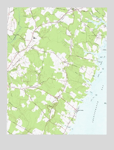
Public Landing, MD USGS Topographic Map
Click on map above to begin viewing in our Map Viewer.

This topographic map contains these locations and features:
Feature Name Type Latitude Longitude GNIS ID View Map
Acquango BranchStreamN38.2173°W75.3685°582859View Map
Basket SwitchLocaleN38.2351°W75.3107°583050View Map
Cedar Chapel SchoolSchoolN38.2257°W75.3402°583640View Map
CedartownPopulated PlaceN38.1960°W75.3035°589929View Map
Central LandfillLocaleN38.2228°W75.3169°2726225View Map
Coonfoot BranchStreamN38.2412°W75.3594°583889View Map
Cotter CoveBayN38.1604°W75.2674°583904View Map
Cotter CreekStreamN38.1610°W75.2696°583905View Map
Cropper NeckCapeN38.2432°W75.2571°583980View Map
District 2, CentralCivilN38.2031°W75.2998°1929538View Map
Ebenezer CemeteryCemeteryN38.1721°W75.3449°584240View Map
Fivemile BranchStreamN38.2304°W75.3571°584404View Map
Handys HammockIslandN38.2098°W75.2530°588925View Map
Harmon LandingPopulated PlaceN38.1968°W75.2605°590422View Map
Harmon Landing EstatesPopulated PlaceN38.2032°W75.2955°1668904View Map
Icehouse BranchStreamN38.2340°W75.2588°585126View Map
Kelly PointCapeN38.1893°W75.2563°585289View Map
Langmaid LandingPopulated PlaceN38.2315°W75.2510°590634View Map
Mason LandingPopulated PlaceN38.2373°W75.2574°590757View Map
Massey BranchStreamN38.2373°W75.2566°585731View Map
Mount WesleyPopulated PlaceN38.1715°W75.3432°590847View Map
Mount Wesley Methodist ChurchChurchN38.1732°W75.3366°1668947View Map
Nathaniels RetreatPopulated PlaceN38.1710°W75.3480°1668959View Map
Newark Volunteer Fire Company - Station 500BuildingN38.2497°W75.2926°2085723View Map
Oak Hill EstatesPopulated PlaceN38.2132°W75.2927°1668973View Map
Old Trinity CemeteryCemeteryN38.2360°W75.3094°586324View Map
Pattys BranchStreamN38.1823°W75.3733°586436View Map
Pawpaw CreekStreamN38.1460°W75.2874°586445View Map
Peters PondLakeN38.1839°W75.2635°586492View Map
Poorhouse BranchStreamN38.2187°W75.3641°586648View Map
Porters CrossingBridgeN38.2229°W75.3633°591053View Map
Public LandingPopulated PlaceN38.1490°W75.2874°586719View Map
Ricks PointCapeN38.1640°W75.2646°588806View Map
Robins CreekStreamN38.1743°W75.2682°588807View Map
Saint Lawrence NeckCapeN38.2237°W75.2630°587060View Map
Scarboro CreekStreamN38.1560°W75.2735°588812View Map
Schoolhouse BranchStreamN38.2073°W75.2563°587243View Map
Snow Hill ChurchChurchN38.2051°W75.3613°587417View Map
Snow Hill MarinaLocaleN38.1323°W75.2963°587418View Map
Snow Hill Mennonite SchoolSchoolN38.2050°W75.3615°2132462View Map
SpencePopulated PlaceN38.1621°W75.3096°588727View Map
Spence Baptist ChurchChurchN38.1612°W75.3144°1669052View Map
Stagg CreekStreamN38.1354°W75.2885°587526View Map
Tanhouse CreekStreamN38.1304°W75.2935°587691View Map
Tilghman Mill BranchStreamN38.2485°W75.3624°587802View Map
Turpin CoveBayN38.1851°W75.2588°587920View Map
Waterworks CreekStreamN38.2043°W75.2613°588080View Map
WesleyPopulated PlaceN38.2101°W75.3446°588742View Map
Windmill CoveBayN38.1985°W75.2546°588284View Map
Windmill PointCapeN38.2007°W75.2588°588288View Map
Worcester Career and Technology CenterSchoolN38.2184°W75.3442°2132540View Map
Worcester CountyCivilN38.2165°W75.2967°1668802View Map

Note: Coordinates in the location and feature list above are referenced to NAD83 datum.


Copyright (C) 2008-2025 Ryan Niemi / Sunset Dynamics ... All Rights Reserved