TopoQuest Logo
Do you find TopoQuest useful?
Help keep TopoQuest running and adding new maps/features by donating!
Bitcoin:  19c7KJd3qBynnjoSw5npx9KScwjBe4ifkT
Litecoin:  LXs6TkuXGGXo1vDsWCkWVdjQX94eUKd6ui
Home View Maps Find Maps Find Places Resources & Links


Boxiron, Maryland Topographic Map

USGS Map Title: Boxiron, MD
USGS Map MRC: 38075A3
DRG (GeoTIFF) Download: o38075a3.tif


Neighboring USGS Topographic Map Quads:


  Snow Hill, MD  
38075B4
 

  Public Landing, MD  
38075B3
 

  Tingles Island, MD  
38075B2
 

  Girdletree, MD  
38075A4
 

  Boxiron, MD  
38075A3
 

  Whittington Point, MD  
38075A2
 

  Chincoteague West, VA  
37075H4
 

  Chincoteague East, VA  
37075H3


Map MRC Location:

N39°
W76°
N39°
W75°
H8 H7 H6 H5 H4 H3 H2 H1
G8 G7 G6 G5 G4 G3 G2 G1
F8 F7 F6 F5 F4 F3 F2 F1
E8 E7 E6 E5 E4 E3 E2 E1
D8 D7 D6 D5 D4 D3 D2 D1
C8 C7 C6 C5 C4 C3 C2 C1
B8 B7 B6 B5 B4 B3 B2 B1
A8 A7 A6 A5 A4 A3 A2 A1
N38°
W76°
N38°
W75°

Boxiron, MD USGS 1:24K Topographic Map Preview:
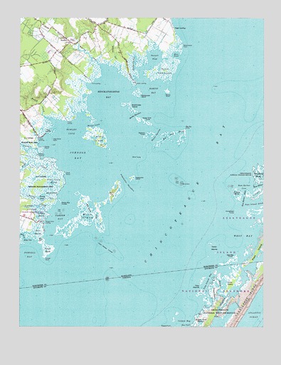
Boxiron, MD USGS Topographic Map
Click on map above to begin viewing in our Map Viewer.

This topographic map contains these locations and features:
Feature Name Type Latitude Longitude GNIS ID View Map
Assacorkin IslandIslandN38.0601°W75.3160°582947View Map
Assacorkin ThorofareChannelN38.0579°W75.3196°582948View Map
Ayres Lane EstatesPopulated PlaceN38.1218°W75.3371°1668812View Map
Bayview (historical)Populated PlaceN38.0873°W75.3741°1668819View Map
Beasey CreekStreamN38.0518°W75.3558°583100View Map
Beasey PondLakeN38.0524°W75.3633°583101View Map
Big Bay MarshSwampN38.0756°W75.2978°583204View Map
Big Bay PointCapeN38.0798°W75.2899°583205View Map
Blue PondLakeN38.1099°W75.2945°583301View Map
BoxironPopulated PlaceN38.1151°W75.3491°588622View Map
Boxiron CreekStreamN38.1060°W75.3338°583345View Map
Boxiron LandingPopulated PlaceN38.0985°W75.3377°591435View Map
Boxiron Pond (historical)ReservoirN38.1151°W75.3450°1668840View Map
Bridge CreekChannelN38.0815°W75.3366°583382View Map
Brimer LandingLocaleN38.1023°W75.3332°1668842View Map
Brockatonorton BayBayN38.0940°W75.3296°583422View Map
Cedar IslandsIslandN38.0340°W75.2760°583653View Map
Clam Harbor TumpsBarN38.0326°W75.3302°583794View Map
Colburns GutStreamN38.1037°W75.3246°583394View Map
Cottman CreekStreamN38.0465°W75.3602°583907View Map
Cottman MarshSwampN38.0454°W75.3635°583908View Map
Duers NeckCapeN38.1062°W75.3199°591745View Map
Duers Neck LandingPopulated PlaceN38.0987°W75.3155°591241View Map
Easter OpeningChannelN38.0773°W75.3049°584228View Map
Figgs LandingPopulated PlaceN38.1210°W75.2960°590207View Map
George Island LandingPopulated PlaceN38.0429°W75.3616°590288View Map
Great NeckCapeN38.0135°W75.2746°1467445View Map
Hallbrooks GutGutN38.1068°W75.3155°584826View Map
Hardys HoleBasinN38.0362°W75.3321°1668903View Map
Hog IslandIslandN38.0793°W75.3605°584994View Map
Hog Island PointCapeN38.0765°W75.3583°584997View Map
Horsehead TumpIslandN38.0468°W75.2644°585083View Map
Hudson LandingPopulated PlaceN38.0835°W75.3510°590511View Map
Hunting PointCapeN38.0673°W75.3552°1668916View Map
Johnson BayBayN38.0693°W75.3446°585251View Map
Knox MarshSwampN38.0382°W75.3649°585332View Map
Martin BayBayN38.0957°W75.3060°588795View Map
Martin PointCapeN38.0951°W75.2991°585716View Map
Mills IslandIslandN38.0448°W75.3399°585895View Map
Mills Island CreekLakeN38.0492°W75.3378°585896View Map
Mink TumpIslandN38.0685°W75.3121°585906View Map
Moss PointCapeN38.0010°W75.2869°1470785View Map
Muddy ThorofareChannelN38.0857°W75.3163°586104View Map
Oak HammockIslandN38.0546°W75.3583°586271View Map
Parker BayBayN38.0443°W75.3541°586407View Map
Parker Bay TumpsIslandN38.0507°W75.3538°586408View Map
Pikes CreekStreamN38.0637°W75.3558°586507View Map
Pikes Creek MarshSwampN38.0477°W75.3683°586508View Map
Pitts IslandIslandN38.0176°W75.2660°1472450View Map
Pope IslandIslandN38.0362°W75.2502°586649View Map
Pope Island DitchCanalN38.0493°W75.2541°586650View Map
Purnell BayBayN38.0290°W75.3694°588805View Map
Purnell HummockIslandN38.1043°W75.3010°587253View Map
Purnell MarshSwampN38.0378°W75.3666°586732View Map
Purnell PointCapeN38.0282°W75.3616°586733View Map
Purnell PondLakeN38.1089°W75.3055°586734View Map
Ragged PointCapeN38.0001°W75.2963°1472935View Map
Rams Horn TumpIslandN38.0890°W75.3269°591779View Map
Ramshorn IslandIslandN38.0887°W75.3269°1669010View Map
Rattlesnake IslandIslandN38.0935°W75.3144°586772View Map
Ready Cove TumpIslandN38.0835°W75.3110°586779View Map
Riley CoveBayN38.0346°W75.3702°586835View Map
Riley CreekStreamN38.0357°W75.3721°586836View Map
Robbins TumpIslandN38.0776°W75.3099°586851View Map
Rowley CoveBayN38.0790°W75.3485°586947View Map
Rowley CreekStreamN38.0823°W75.3558°586948View Map
Rum HarborBayN38.0568°W75.2524°586955View Map
Rum Harbor CoveBayN38.0568°W75.2596°586956View Map
Rum Harbor DitchChannelN38.0532°W75.2594°586957View Map
Rum Harbor MarshSwampN38.0593°W75.2513°586958View Map
Saint Matthew United Methodist ChurchChurchN38.1190°W75.3413°1669027View Map
Sandy PointCapeN38.0723°W75.3627°587204View Map
Sassafras HammockIslandN38.0571°W75.3549°1669035View Map
Scarboro CreekStreamN38.0701°W75.3652°587241View Map
Scarboro LandingPopulated PlaceN38.0693°W75.3666°591236View Map
Selbys GutStreamN38.1048°W75.3157°591785View Map
Shell PointCapeN38.0621°W75.3521°587320View Map
Shelldrake IslandIslandN38.0890°W75.3182°587323View Map
Striking MarshSwampN38.0521°W75.2627°587604View Map
Taylor LandingPopulated PlaceN38.0754°W75.3655°591394View Map
Terrapin CreekChannelN38.0543°W75.2521°587724View Map
The DitchCanalN38.0357°W75.3641°587742View Map
Tizzard IslandIslandN38.0762°W75.3344°587813View Map
Toby Island BayBayN38.0182°W75.2791°1475748View Map
Toby IslandsIslandN38.0165°W75.2816°1475749View Map
Virginia CreekStreamN38.0204°W75.2732°1476199View Map
Watermelon PointCapeN38.1143°W75.2919°588073View Map
West BayBayN38.0371°W75.2596°588135View Map
West Bay TumpIslandN38.0285°W75.2638°588136View Map
Whales Gizzard ShoalsBarN38.0960°W75.2566°591796View Map
White RockBarN38.0579°W75.2919°588208View Map

Note: Coordinates in the location and feature list above are referenced to NAD83 datum.


Copyright (C) 2008-2024 Ryan Niemi / Sunset Dynamics ... All Rights Reserved