TopoQuest Logo
Do you find TopoQuest useful?
Help keep TopoQuest running and adding new maps/features by donating!
Bitcoin:  19c7KJd3qBynnjoSw5npx9KScwjBe4ifkT
Litecoin:  LXs6TkuXGGXo1vDsWCkWVdjQX94eUKd6ui
Home View Maps Find Maps Find Places Resources & Links


Girdletree, Maryland Topographic Map

USGS Map Title: Girdletree, MD
USGS Map MRC: 38075A4
DRG (GeoTIFF) Download: o38075a4.tif


Neighboring USGS Topographic Map Quads:


  Snow Hill, MD  
38075B4
 

  Public Landing, MD  
38075B3
 

  Pocomoke City, MD  
38075A5
 

  Girdletree, MD  
38075A4
 

  Boxiron, MD  
38075A3
 

  Hallwood, VA  
37075H5
 

  Chincoteague West, VA  
37075H4
 

  Chincoteague East, VA  
37075H3


Map MRC Location:

N39°
W76°
N39°
W75°
H8 H7 H6 H5 H4 H3 H2 H1
G8 G7 G6 G5 G4 G3 G2 G1
F8 F7 F6 F5 F4 F3 F2 F1
E8 E7 E6 E5 E4 E3 E2 E1
D8 D7 D6 D5 D4 D3 D2 D1
C8 C7 C6 C5 C4 C3 C2 C1
B8 B7 B6 B5 B4 B3 B2 B1
A8 A7 A6 A5 A4 A3 A2 A1
N38°
W76°
N38°
W75°

Girdletree, MD USGS 1:24K Topographic Map Preview:
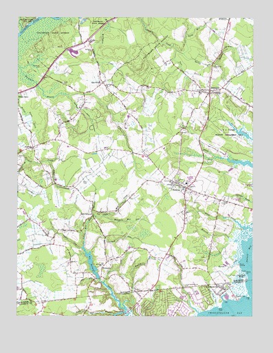
Girdletree, MD USGS Topographic Map
Click on map above to begin viewing in our Map Viewer.

This topographic map contains these locations and features:
Feature Name Type Latitude Longitude GNIS ID View Map
Bessen CreekStreamN38.0235°W75.3810°583169View Map
Bessen LandingPopulated PlaceN38.0215°W75.3816°589741View Map
Beth Eden CemeteryCemeteryN38.1113°W75.4607°583175View Map
Beth Eden CemeteryCemeteryN38.1151°W75.4619°583176View Map
Betheden Church (historical)ChurchN38.1148°W75.4619°1668836View Map
Big Mill (historical)LocaleN38.0160°W75.4558°1668837View Map
Big MillpondLakeN38.0222°W75.4601°583224View Map
Big Millpond DamDamN38.0226°W75.4602°594365View Map
Bunn DitchCanalN38.0193°W75.4474°583482View Map
Captains Cove Census Designated PlaceCensusN38.0003°W75.4174°2584822View Map
Church Street CemeteryCemeteryN38.0562°W75.4165°1668854View Map
Church Street SchoolSchoolN38.0562°W75.4171°583788View Map
Cool Spring CemeteryCemeteryN38.1128°W75.3906°1668859View Map
Cool Spring ChurchChurchN38.1126°W75.3899°583883View Map
Cottingham Mill RunStreamN38.1198°W75.4977°583906View Map
District 1, SouthernCivilN38.0735°W75.4008°1929424View Map
District 8, Stockton (historical)CivilN38.0698°W75.4259°1929700View Map
Episcopal Chapel of the Holy CrossChurchN38.0560°W75.4160°1668874View Map
Franklin CityPopulated PlaceN38.0079°W75.3835°1494944View Map
GirdletreePopulated PlaceN38.0946°W75.3974°590303View Map
Girdletree Census Designated PlaceCensusN38.0987°W75.4004°2389843View Map
Girdletree Post OfficePost OfficeN38.0934°W75.3974°1668886View Map
Girdletree Volunteer Fire Company - Station 300BuildingN38.0930°W75.3980°2085721View Map
GoodwillPopulated PlaceN38.0707°W75.4916°588665View Map
Goodwill Baptist ChurchChurchN38.0701°W75.4927°1668890View Map
Goodwill DitchCanalN38.0554°W75.4799°584642View Map
Goodwill Methodist CemeteryCemeteryN38.0668°W75.4996°584641View Map
Goose PointCapeN38.0187°W75.3783°584658View Map
Goose Point MarshSwampN38.0139°W75.3817°584662View Map
GreenbackvillePopulated PlaceN38.0115°W75.3902°1494969View Map
Greenbackville Census Designated PlaceCensusN38.0104°W75.3870°2584852View Map
Greenbackville Post OfficePost OfficeN38.0113°W75.3890°2519614View Map
Greenbackville Volunteer Fire DepartmentBuildingN38.0122°W75.3907°2075653View Map
Gunby Memorial Presbyterian ChurchChurchN38.0546°W75.4083°584799View Map
Gunby Methodist CemeteryCemeteryN38.0543°W75.4083°1668898View Map
Guys PointCapeN38.0040°W75.3910°1467617View Map
Guys Point GutStreamN38.0043°W75.3933°1467618View Map
Hancock CemeteryCemeteryN38.0784°W75.4596°1668900View Map
Hancock CreekStreamN38.0304°W75.3805°584851View Map
Holly Swamp (historical)SwampN38.0551°W75.4635°1668912View Map
Jones DitchCanalN38.0829°W75.4494°585272View Map
Kelly Mill BranchStreamN38.1101°W75.4119°585288View Map
Klej GrangeLocaleN38.0979°W75.4544°585326View Map
Little Mill CreekStreamN38.0418°W75.4585°585485View Map
Little Mill RunStreamN38.0315°W75.4644°585487View Map
Little MillpondReservoirN38.0418°W75.4563°1668932View Map
Little MillpondLocaleN38.0423°W75.4596°585488View Map
Little Millpond (historical)ReservoirN38.0418°W75.4585°1668933View Map
Little Red SchoolSchoolN38.0551°W75.4163°585503View Map
Long PointCapeN38.0076°W75.3752°1469831View Map
Marshall DitchCanalN38.0312°W75.4708°585707View Map
Marshall Mill RunStreamN38.0421°W75.4524°585709View Map
Milburn LandingPopulated PlaceN38.1248°W75.4899°590798View Map
Mount Hope Baptist CemeteryCemeteryN38.0218°W75.4546°1668944View Map
Mount Hope ChurchChurchN38.0218°W75.4544°586004View Map
Old Shiloh CemeteryCemeteryN38.1046°W75.4880°586322View Map
Owl Hollow AcresPopulated PlaceN38.0818°W75.4374°1668982View Map
Paradie BranchStreamN38.0421°W75.4585°586395View Map
Payne DitchCanalN38.0329°W75.4430°586447View Map
Portersville CemeteryCemeteryN38.0482°W75.3900°1669005View Map
Portersville ChurchChurchN38.0482°W75.3899°586680View Map
Powell CreekStreamN38.0012°W75.4033°1472731View Map
Rayfield DitchCanalN38.0860°W75.4646°586777View Map
Redden CreekStreamN38.0646°W75.4949°586792View Map
Remson ChurchChurchN38.0226°W75.4710°586805View Map
Remson Methodist CemeteryCemeteryN38.0222°W75.4709°1669012View Map
Saint Lukes CemeteryCemeteryN38.0964°W75.4527°1669021View Map
Saint Lukes ChurchChurchN38.0968°W75.4530°587067View Map
Saint Marks CemeteryCemeteryN38.0433°W75.4568°1669022View Map
Saint Marks ChurchChurchN38.0435°W75.4566°587076View Map
Saint Pauls ChurchChurchN38.0568°W75.4152°587122View Map
Saint Pauls School (historical)SchoolN38.0332°W75.4533°1669031View Map
Sand BranchStreamN38.0035°W75.4424°587181View Map
Sand BranchStreamN38.0035°W75.4421°1473991View Map
Selby Mill BranchStreamN38.0015°W75.4427°1474157View Map
Shiloh CemeteryCemeteryN38.0977°W75.4759°587333View Map
Shiloh ChurchChurchN38.0998°W75.4869°587335View Map
Snider DamDamN38.0018°W75.4430°1488981View Map
Spring Hill BranchStreamN38.1115°W75.4155°587507View Map
Spring Hill CemeteryCemeteryN38.1046°W75.3958°587509View Map
Steel Pond (historical)LocaleN38.0215°W75.4713°1669054View Map
StocktonPopulated PlaceN38.0537°W75.4099°591353View Map
Stockton Census Designated PlaceCensusN38.0659°W75.4134°2390356View Map
Stockton Post OfficePost OfficeN38.0535°W75.4105°1669056View Map
Stockton Volunteer Fire Company - Station 200BuildingN38.0542°W75.4099°2085720View Map
Tarr BranchStreamN38.1115°W75.4152°587702View Map
Union Franklin City CemeteryCemeteryN38.0237°W75.3988°587965View Map
Union Greenbackville CemeteryCemeteryN38.0129°W75.4105°587966View Map
Vaughn State Wildlife Management AreaParkN38.0762°W75.3874°588936View Map
Ward DitchCanalN38.0160°W75.4627°588040View Map
WelbournePopulated PlaceN38.0201°W75.4544°591505View Map
Wesley CemeteryCemeteryN38.0548°W75.4133°1669085View Map
Wesley ChurchChurchN38.0548°W75.4130°588123View Map

Note: Coordinates in the location and feature list above are referenced to NAD83 datum.


Copyright (C) 2008-2024 Ryan Niemi / Sunset Dynamics ... All Rights Reserved