TopoQuest Logo
Do you find TopoQuest useful?
Help keep TopoQuest running and adding new maps/features by donating!
Bitcoin:  19c7KJd3qBynnjoSw5npx9KScwjBe4ifkT
Litecoin:  LXs6TkuXGGXo1vDsWCkWVdjQX94eUKd6ui
Home View Maps Find Maps Find Places Resources & Links


Bradford, Maine Topographic Map

USGS Map Title: Bradford, ME
USGS Map MRC: 45068A8
DRG (GeoTIFF) Download: o45068a8.tif


Neighboring USGS Topographic Map Quads:


  South Sebec, ME  
45069B1
 

  Milo South, ME  
45068B8
 

  Lagrange, ME  
45068B7
 

  Charleston, ME  
45069A1
 

  Bradford, ME  
45068A8
 

  South Lagrange, ME  
45068A7
 

  West Corinth, ME  
44069H1
 

  Kenduskeag, ME  
44068H8
 

  Pushaw Lake, ME  
44068H7


Map MRC Location:

N46°
W69°
N46°
W68°
H8 H7 H6 H5 H4 H3 H2 H1
G8 G7 G6 G5 G4 G3 G2 G1
F8 F7 F6 F5 F4 F3 F2 F1
E8 E7 E6 E5 E4 E3 E2 E1
D8 D7 D6 D5 D4 D3 D2 D1
C8 C7 C6 C5 C4 C3 C2 C1
B8 B7 B6 B5 B4 B3 B2 B1
A8 A7 A6 A5 A4 A3 A2 A1
N45°
W69°
N45°
W68°

Bradford, ME USGS 1:24K Topographic Map Preview:
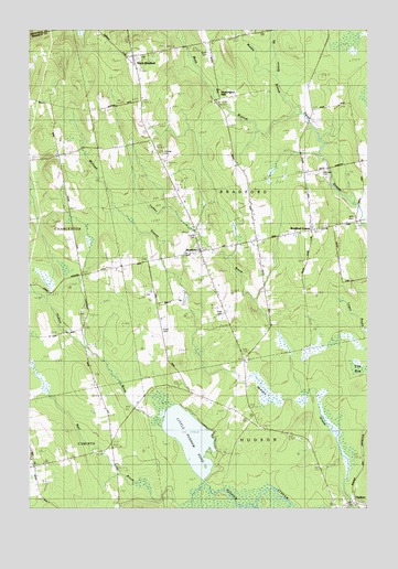
Bradford, ME USGS Topographic Map
Click on map above to begin viewing in our Map Viewer.

This topographic map contains these locations and features:
Feature Name Type Latitude Longitude GNIS ID View Map
Bear BrookStreamN45.0078°W68.9356°561816View Map
Beaver BrookStreamN45.1123°W68.9086°561910View Map
BradfordPopulated PlaceN45.0667°W68.9378°562852View Map
Bradford Baptist ChurchChurchN45.0684°W68.9370°1913352View Map
Bradford CenterPopulated PlaceN45.0723°W68.8961°562856View Map
Bradford Elementary SchoolSchoolN45.0801°W68.9420°2737952View Map
Bradford Emergency Medical Ambulance ServiceBuildingN45.0698°W68.9154°2666834View Map
Bradford Fire and Rescue DepartmentBuildingN45.0699°W68.9153°2553179View Map
Bradford High SchoolSchoolN45.0692°W68.9153°562857View Map
Bradford Post OfficePost OfficeN45.0736°W68.8952°1913354View Map
Corner CemeteryCemeteryN45.0712°W68.9376°562855View Map
Davis BrookStreamN45.0795°W68.9981°564799View Map
Forbes BrookStreamN45.0301°W68.8978°566370View Map
Heartstone Farm AirportAirportN45.0443°W68.9924°2717194View Map
Hillside CemeteryCemeteryN45.0924°W68.9508°572257View Map
HudsonPopulated PlaceN45.0012°W68.8806°568430View Map
Hudson BrookStreamN45.0237°W68.9503°568432View Map
Hudson Post OfficePost OfficeN45.0008°W68.8833°1913610View Map
Huntington MillPopulated PlaceN45.1067°W68.9298°579419View Map
John B Curtis Free Public LibraryBuildingN45.0665°W68.9361°2738485View Map
Keyser BrookStreamN45.0042°W68.9331°569138View Map
Little Pushaw PondLakeN45.0183°W68.9402°569990View Map
Middle Branch Dead StreamStreamN45.1028°W68.9003°571213View Map
Mills CemeteryCemeteryN45.0765°W68.8795°571316View Map
Mohawk StreamStreamN45.0001°W68.8825°571484View Map
North BradfordPopulated PlaceN45.1181°W68.9617°572256View Map
North Bradford SchoolSchoolN45.1059°W68.9586°572258View Map
Pond CemeteryCemeteryN45.0465°W68.9503°2727065View Map
Town of BradfordCivilN45.0883°W68.9067°582363View Map
Trask CemeteryCemeteryN45.0508°W68.9282°577280View Map
Williams CemeteryCemeteryN45.0876°W68.8919°578514View Map
Williams SchoolSchoolN45.0898°W68.8989°578525View Map

Note: Coordinates in the location and feature list above are referenced to NAD83 datum.


Copyright (C) 2008-2024 Ryan Niemi / Sunset Dynamics ... All Rights Reserved