TopoQuest Logo
Do you find TopoQuest useful?
Help keep TopoQuest running and adding new maps/features by donating!
Bitcoin:  19c7KJd3qBynnjoSw5npx9KScwjBe4ifkT
Litecoin:  LXs6TkuXGGXo1vDsWCkWVdjQX94eUKd6ui
Home View Maps Find Maps Find Places Resources & Links


Pyrmont, Missouri Topographic Map

USGS Map Title: Pyrmont, MO
USGS Map MRC: 38093E1
DRG (GeoTIFF) Download: o38093e1.tif


Neighboring USGS Topographic Map Quads:


  Sedalia East, MO  
38093F2
 

  Otterville West, MO  
38093F1
 

  Otterville East, MO  
38092F8
 

  Bahner, MO  
38093E2
 

  Pyrmont, MO  
38093E1
 

  Florence, MO  
38092E8
 

  Cole Camp, MO  
38093D2
 

  Crockerville, MO  
38093D1
 

  Stover, MO  
38092D8


Map MRC Location:

N39°
W94°
N39°
W93°
H8 H7 H6 H5 H4 H3 H2 H1
G8 G7 G6 G5 G4 G3 G2 G1
F8 F7 F6 F5 F4 F3 F2 F1
E8 E7 E6 E5 E4 E3 E2 E1
D8 D7 D6 D5 D4 D3 D2 D1
C8 C7 C6 C5 C4 C3 C2 C1
B8 B7 B6 B5 B4 B3 B2 B1
A8 A7 A6 A5 A4 A3 A2 A1
N38°
W94°
N38°
W93°

Pyrmont, MO USGS 1:24K Topographic Map Preview:
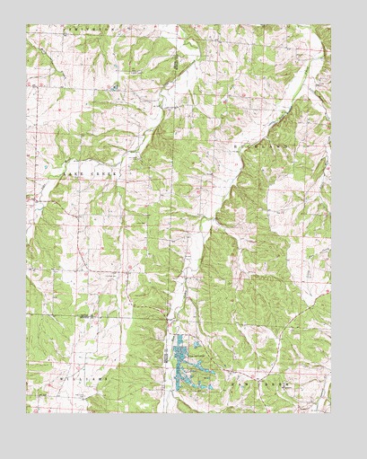
Pyrmont, MO USGS Topographic Map
Click on map above to begin viewing in our Map Viewer.

This topographic map contains these locations and features:
Feature Name Type Latitude Longitude GNIS ID View Map
Bebra (historical)LocaleN38.5403°W93.0549°744784View Map
Black Jack School (historical)SchoolN38.6053°W93.0421°745289View Map
Bunker Hill School (historical)SchoolN38.5528°W93.0952°745449View Map
Holy Cross CemeteryCemeteryN38.5053°W93.1010°719742View Map
Lake Creek CemeteryCemeteryN38.5817°W93.0796°720749View Map
Lake Creek ChurchChurchN38.6095°W93.0819°720750View Map
Lake Creek Volunteer Fire DepartmentBuildingN38.5460°W93.1026°2621500View Map
Lamb Immanuel CemeteryCemeteryN38.5610°W93.0763°720773View Map
Little Haw CreekStreamN38.5631°W93.0002°721246View Map
Lutman (historical)LocaleN38.6103°W93.0874°744981View Map
Martens School (historical)SchoolN38.5039°W93.0274°745291View Map
Oakland School (historical)SchoolN38.5603°W93.0421°745290View Map
PyrmontPopulated PlaceN38.5089°W93.0196°755565View Map
Pyrmont Lutheran Cemetery (Evangelical Luthern Church in America)CemeteryN38.5093°W93.0193°2702560View Map
Ringen School (historical)SchoolN38.6036°W93.0913°745448View Map
Saint Paul Lutheran CemeteryCemeteryN38.5438°W93.0922°725866View Map
Township of Lake CreekCivilN38.5769°W93.1210°767169View Map
Trinity Lutheran Cemetery PyrmontCemeteryN38.5054°W93.0155°2702559View Map

Note: Coordinates in the location and feature list above are referenced to NAD83 datum.


Copyright (C) 2008-2025 Ryan Niemi / Sunset Dynamics ... All Rights Reserved