TopoQuest Logo
Do you find TopoQuest useful?
Help keep TopoQuest running and adding new maps/features by donating!
Bitcoin:  19c7KJd3qBynnjoSw5npx9KScwjBe4ifkT
Litecoin:  LXs6TkuXGGXo1vDsWCkWVdjQX94eUKd6ui
Home View Maps Find Maps Find Places Resources & Links


Sedalia East, Missouri Topographic Map

USGS Map Title: Sedalia East, MO
USGS Map MRC: 38093F2
DRG (GeoTIFF) Download: o38093f2.tif


Neighboring USGS Topographic Map Quads:


  Hughesville, MO  
38093G3
 

  Beaman, MO  
38093G2
 

  Clifton City, MO  
38093G1
 

  Sedalia West, MO  
38093F3
 

  Sedalia East, MO  
38093F2
 

  Otterville West, MO  
38093F1
 

  Ionia, MO  
38093E3
 

  Bahner, MO  
38093E2
 

  Pyrmont, MO  
38093E1


Map MRC Location:

N39°
W94°
N39°
W93°
H8 H7 H6 H5 H4 H3 H2 H1
G8 G7 G6 G5 G4 G3 G2 G1
F8 F7 F6 F5 F4 F3 F2 F1
E8 E7 E6 E5 E4 E3 E2 E1
D8 D7 D6 D5 D4 D3 D2 D1
C8 C7 C6 C5 C4 C3 C2 C1
B8 B7 B6 B5 B4 B3 B2 B1
A8 A7 A6 A5 A4 A3 A2 A1
N38°
W94°
N38°
W93°

Sedalia East, MO USGS 1:24K Topographic Map Preview:
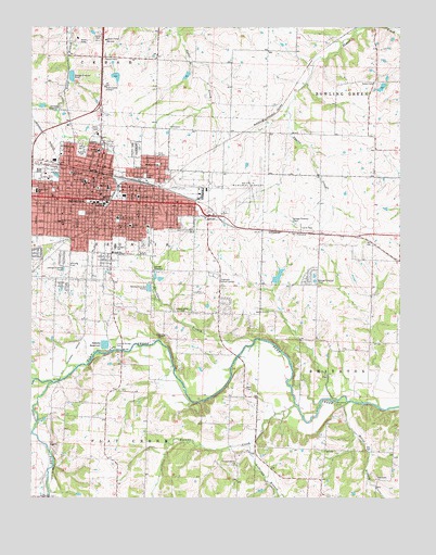
Sedalia East, MO USGS Topographic Map
Click on map above to begin viewing in our Map Viewer.

This topographic map contains these locations and features:
Feature Name Type Latitude Longitude GNIS ID View Map
Abell CemeteryCemeteryN38.6542°W93.1777°713123View Map
Alcolac Lake DamDamN38.7217°W93.1769°763370View Map
Anderson BranchStreamN38.6389°W93.1763°713276View Map
Backbone FordLocaleN38.6503°W93.1469°713518View Map
Bethlehem Baptist ChurchChurchN38.6250°W93.2460°714100View Map
Bothwell Regional Health Center HeliportAirportN38.6986°W93.2224°758935View Map
Bothwell Regional Medical CenterHospitalN38.6994°W93.2213°714550View Map
Breakfast BranchStreamN38.6670°W93.1749°714663View Map
Centennial ParkParkN38.6931°W93.2099°715628View Map
City of SedaliaCivilN38.7043°W93.2349°2396567View Map
Covered Bridge ParkParkN38.6661°W93.2221°716400View Map
Crown Hill CemeteryCemeteryN38.7166°W93.2154°716557View Map
Faith SchoolSchoolN38.6900°W93.2224°717829View Map
Flat Creek ChurchChurchN38.6300°W93.1335°717990View Map
Frederick Lake DamDamN38.7400°W93.1969°763372View Map
Goodwill ChapelChurchN38.6684°W93.2052°718574View Map
Heber Hunt Elementary SchoolSchoolN38.7067°W93.2486°719326View Map
Hebrew CemeteryCemeteryN38.6873°W93.2377°719327View Map
Hermora Lake DamDamN38.6817°W93.1669°763090View Map
Highland Sacred Gardens CemeteryCemeteryN38.6843°W93.1892°719573View Map
Horace Mann Elementary SchoolSchoolN38.6984°W93.2408°719827View Map
Howsel ParkParkN38.7106°W93.2116°719936View Map
Hubbard ParkParkN38.7172°W93.2333°719941View Map
Hubbard SchoolSchoolN38.7172°W93.2272°719942View Map
Jefferson SchoolSchoolN38.7136°W93.2074°720283View Map
KCBW-FM (Sedalia)TowerN38.7311°W93.2258°759044View Map
KSIS-AM (Sedalia)TowerN38.7311°W93.2258°754270View Map
Lake AlcolacReservoirN38.7206°W93.1781°763371View Map
Lake BubidaReservoirN38.6837°W93.1667°763091View Map
Liberty ParkParkN38.7108°W93.2444°720985View Map
Liberty School (historical)SchoolN38.6431°W93.2246°745433View Map
Maplewood School (historical)SchoolN38.6892°W93.1533°745429View Map
Mark Twain SchoolSchoolN38.7117°W93.2366°721876View Map
Marvin Howard LakeReservoirN38.7368°W93.2216°764017View Map
McGee BranchStreamN38.6506°W93.1421°722105View Map
McVey School (historical)SchoolN38.6970°W93.1899°745428View Map
Mosby School (historical)SchoolN38.6445°W93.1835°745432View Map
North Branch Pearl RiverStreamN38.7205°W93.2354°2764677View Map
Parkview Elementary SchoolSchoolN38.6939°W93.2077°2545334View Map
Pettis County Fire Protection District Station 2BuildingN38.6739°W93.1723°2621282View Map
Pettis County Juvenile CenterSchoolN38.7037°W93.2248°2545225View Map
Pettis County Sheriff's OfficeBuildingN38.7080°W93.2267°2752151View Map
Pin Oak School (historical)SchoolN38.6384°W93.1527°745431View Map
Pleasant Hill ChurchChurchN38.6342°W93.1813°724533View Map
Rader Lake DamDamN38.7383°W93.2219°764016View Map
Sacred Heart Catholic SchoolSchoolN38.7091°W93.2320°725707View Map
Saint Paul's Lutheran SchoolSchoolN38.7057°W93.2267°725885View Map
Salem CemeteryCemeteryN38.7353°W93.1335°725927View Map
Salem School (historical)SchoolN38.7361°W93.1380°745427View Map
SedaliaPopulated PlaceN38.7045°W93.2283°729812View Map
Sedalia Fire Department Central Fire StationBuildingN38.7059°W93.2199°2621108View Map
Sedalia Middle SchoolSchoolN38.6915°W93.2218°2545460View Map
Sedalia Police DepartmentBuildingN38.7098°W93.2296°2752482View Map
Sedalia Post OfficePost OfficeN38.7073°W93.2243°2782906View Map
Sedalia Regional AirportAirportN38.7099°W93.1756°758934View Map
Sedalia ReservoirReservoirN38.6658°W93.2253°726181View Map
Smith - Cotton High SchoolSchoolN38.7037°W93.2248°726610View Map
Spring ForkStreamN38.6556°W93.2427°726915View Map
Striped College SchoolSchoolN38.6747°W93.1983°727184View Map
Sunny Side School (historical)SchoolN38.7328°W93.2074°745426View Map
Tempel LakeReservoirN38.7340°W93.1314°763068View Map
Tempel Lake DamDamN38.7350°W93.1302°763067View Map
Township of SedaliaCivilN38.6925°W93.2292°767173View Map
ValdaLocaleN38.6250°W93.2460°745434View Map
Vermont ParkParkN38.7006°W93.2330°728170View Map
Walnut CreekStreamN38.6497°W93.1608°728297View Map
Washington Elementary SchoolSchoolN38.7050°W93.2140°728382View Map
White School (historical)SchoolN38.6697°W93.1266°745430View Map
Whittier High SchoolSchoolN38.6973°W93.2169°728808View Map

Note: Coordinates in the location and feature list above are referenced to NAD83 datum.


Copyright (C) 2008-2025 Ryan Niemi / Sunset Dynamics ... All Rights Reserved