TopoQuest Logo
Do you find TopoQuest useful?
Help keep TopoQuest running and adding new maps/features by donating!
Bitcoin:  19c7KJd3qBynnjoSw5npx9KScwjBe4ifkT
Litecoin:  LXs6TkuXGGXo1vDsWCkWVdjQX94eUKd6ui
Home View Maps Find Maps Find Places Resources & Links


Otterville West, Missouri Topographic Map

USGS Map Title: Otterville West, MO
USGS Map MRC: 38093F1
DRG (GeoTIFF) Download: o38093f1.tif


Neighboring USGS Topographic Map Quads:


  Beaman, MO  
38093G2
 

  Clifton City, MO  
38093G1
 

  Pilot Grove South, MO  
38092G8
 

  Sedalia East, MO  
38093F2
 

  Otterville West, MO  
38093F1
 

  Otterville East, MO  
38092F8
 

  Bahner, MO  
38093E2
 

  Pyrmont, MO  
38093E1
 

  Florence, MO  
38092E8


Map MRC Location:

N39°
W94°
N39°
W93°
H8 H7 H6 H5 H4 H3 H2 H1
G8 G7 G6 G5 G4 G3 G2 G1
F8 F7 F6 F5 F4 F3 F2 F1
E8 E7 E6 E5 E4 E3 E2 E1
D8 D7 D6 D5 D4 D3 D2 D1
C8 C7 C6 C5 C4 C3 C2 C1
B8 B7 B6 B5 B4 B3 B2 B1
A8 A7 A6 A5 A4 A3 A2 A1
N38°
W94°
N38°
W93°

Otterville West, MO USGS 1:24K Topographic Map Preview:
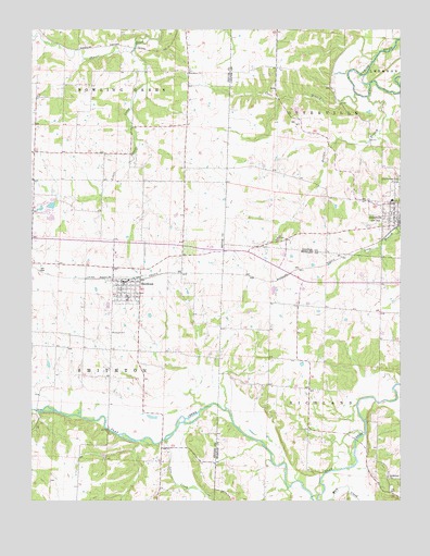
Otterville West, MO USGS Topographic Map
Click on map above to begin viewing in our Map Viewer.

This topographic map contains these locations and features:
Feature Name Type Latitude Longitude GNIS ID View Map
Arator School (historical)SchoolN38.7145°W93.0916°745435View Map
Bethlehem ChurchChurchN38.6314°W93.0044°714101View Map
Brushy School (historical)SchoolN38.6353°W93.0863°745436View Map
City of OttervilleCivilN38.7029°W93.0028°2396108View Map
City of SmithtonCivilN38.6812°W93.0930°2395902View Map
Clear BranchStreamN38.7328°W93.0155°715920View Map
Dick Monsees DamDamN38.7000°W93.1202°764078View Map
Harlan BranchStreamN38.7320°W93.0113°719096View Map
Haw CreekStreamN38.6253°W93.0271°719220View Map
Hermora LakeReservoirN38.7032°W93.1186°763093View Map
Klein School (historical)SchoolN38.7267°W93.0338°743883View Map
Lake CreekStreamN38.6411°W93.0791°720746View Map
Lake of the Ozarks Planning RegionCivilN38.6253°W93.0003°754105View Map
Little Shaver CreekStreamN38.7439°W93.0910°721314View Map
Monsees LakeReservoirN38.7000°W93.1186°764079View Map
OttervillePopulated PlaceN38.6997°W93.0021°723884View Map
Otterville Elementary SchoolSchoolN38.7048°W93.0023°2571137View Map
Otterville High SchoolSchoolN38.7048°W93.0029°2571139View Map
Otterville Post OfficePost OfficeN38.6989°W93.0009°2782842View Map
Providence ChurchChurchN38.7384°W93.0721°724971View Map
Rubydo Lake DamDamN38.7034°W93.1169°763092View Map
Selken Lake DamDamN38.6767°W93.1152°765422View Map
SmithtonPopulated PlaceN38.6800°W93.0930°729814View Map
Smithton CemeteryCemeteryN38.6698°W93.0988°726638View Map
Smithton Elementary SchoolSchoolN38.6785°W93.0929°2545378View Map
Smithton High SchoolSchoolN38.6793°W93.0926°2545396View Map
Smithton Police DepartmentBuildingN38.6832°W93.0933°2752180View Map
Smithton Post OfficePost OfficeN38.6828°W93.0948°2779468View Map
Smithton Volunteer Fire Protection AssociationBuildingN38.6831°W93.0923°2620920View Map
Steele Lake DamDamN38.6367°W93.1002°764524View Map
Stony Point School (historical)SchoolN38.6620°W93.0419°745283View Map
Township of OttervilleCivilN38.7371°W93.0207°766534View Map
Township of SmithtonCivilN38.6660°W93.1171°767174View Map

Note: Coordinates in the location and feature list above are referenced to NAD83 datum.


Copyright (C) 2008-2025 Ryan Niemi / Sunset Dynamics ... All Rights Reserved