TopoQuest Logo
Do you find TopoQuest useful?
Help keep TopoQuest running and adding new maps/features by donating!
Bitcoin:  19c7KJd3qBynnjoSw5npx9KScwjBe4ifkT
Litecoin:  LXs6TkuXGGXo1vDsWCkWVdjQX94eUKd6ui
Home View Maps Find Maps Find Places Resources & Links


Rabun Bald, Georgia Topographic Map

USGS Map Title: Rabun Bald, GA
USGS Map MRC: 34083H3
DRG (GeoTIFF) Download: o34083h3.tif


Neighboring USGS Topographic Map Quads:


  Prentiss, NC  
35083A4
 

  Scaly Mountain, NC  
35083A3
 

  Highlands, NC  
35083A2
 

  Dillard, GA  
34083H4
 

  Rabun Bald, GA  
34083H3
 

  Satolah, GA  
34083H2
 

  Tiger, GA  
34083G4
 

  Rainy Mountain, GA  
34083G3
 

  Whetstone, SC  
34083G2


Map MRC Location:

N35°
W84°
N35°
W83°
H8 H7 H6 H5 H4 H3 H2 H1
G8 G7 G6 G5 G4 G3 G2 G1
F8 F7 F6 F5 F4 F3 F2 F1
E8 E7 E6 E5 E4 E3 E2 E1
D8 D7 D6 D5 D4 D3 D2 D1
C8 C7 C6 C5 C4 C3 C2 C1
B8 B7 B6 B5 B4 B3 B2 B1
A8 A7 A6 A5 A4 A3 A2 A1
N34°
W84°
N34°
W83°

Rabun Bald, GA USGS 1:24K Topographic Map Preview:
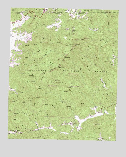
Rabun Bald, GA USGS Topographic Map
Click on map above to begin viewing in our Map Viewer.

This topographic map contains these locations and features:
Feature Name Type Latitude Longitude GNIS ID View Map
Addie BranchStreamN34.9737°W83.2532°326915View Map
Addie GapGapN34.9565°W83.2713°326916View Map
Alex GapGapN34.9670°W83.3290°326929View Map
Alex MountainSummitN34.9712°W83.3268°331017View Map
AntiochPopulated PlaceN34.8912°W83.2990°326957View Map
Antioch ChurchChurchN34.8926°W83.2990°351461View Map
Apple ValleyValleyN34.9274°W83.2641°326963View Map
Bailey BranchStreamN34.9734°W83.2588°326990View Map
Battle BranchStreamN34.8818°W83.3660°327019View Map
Battle Branch ChurchChurchN34.8820°W83.3671°354482View Map
Beck MountainRidgeN34.9168°W83.2638°327046View Map
Beck RidgeRidgeN34.9101°W83.3290°327047View Map
Becky BranchStreamN34.8826°W83.3504°327048View Map
Beegum GapGapN34.9787°W83.3029°327060View Map
Ben MountainSummitN34.9651°W83.3479°331131View Map
Big MountainSummitN34.9098°W83.2913°331164View Map
Big RidgeRidgeN34.9470°W83.2868°327119View Map
Black Diamond TunnelTunnelN34.8840°W83.2846°330573View Map
Blacks Creek KnobSummitN34.9298°W83.3432°331176View Map
Blackstump GapGapN34.9306°W83.3213°327154View Map
Buck BranchStreamN34.8845°W83.3213°327256View Map
Chestnut GapGapN34.9718°W83.2918°327441View Map
Chestnut MountainSummitN34.9523°W83.3577°331388View Map
Chestnut RidgeRidgeN34.9706°W83.2949°327445View Map
City of Sky ValleyCivilN34.9841°W83.3314°2405468View Map
Coldspring GapGapN34.9618°W83.2827°327492View Map
Commissioners RockLocaleN34.9962°W83.2971°327503View Map
Courthouse GapGapN34.8990°W83.3679°327531View Map
Dan GapGapN34.9251°W83.3077°327590View Map
Dan RidgeRidgeN34.9229°W83.3065°327591View Map
Deep GapGapN34.9081°W83.3279°327623View Map
Dotson CemeteryCemeteryN34.8793°W83.3679°327668View Map
Double KnobSummitN34.9426°W83.3218°331578View Map
Ducks Nest GapGapN34.9234°W83.2721°327706View Map
Duncan CemeteryCemeteryN34.9704°W83.2515°327714View Map
Emory BranchStreamN34.9812°W83.2604°327763View Map
Estatoah FallsFallsN34.9912°W83.3443°327773View Map
Finney CreekStreamN34.8856°W83.3390°327817View Map
Flat TopSummitN34.9512°W83.3154°355834View Map
Flint GapGapN34.9648°W83.3054°327849View Map
Flint KnobSummitN34.9676°W83.3146°331731View Map
FodderstackSummitN34.9718°W83.2899°331737View Map
Ford MountainSummitN34.9893°W83.3049°331740View Map
Goble GapGapN34.9076°W83.2582°327950View Map
Green CemeteryCemeteryN34.8840°W83.3402°328001View Map
Green GapGapN34.8768°W83.3388°328002View Map
Hale CemeteryCemeteryN34.9531°W83.2515°351475View Map
Hale ChurchChurchN34.9695°W83.2518°330751View Map
Hale Church CemeteryCemeteryN34.9531°W83.2515°328035View Map
Hale RidgeRidgeN34.9501°W83.2604°328036View Map
Hoods CreekStreamN34.9115°W83.2788°328205View Map
Hoojah BranchStreamN34.9576°W83.3529°328206View Map
Indian Grave HillSummitN34.9062°W83.3015°332057View Map
Katy KnobSummitN34.9212°W83.2704°332131View Map
Kell CemeteryCemeteryN34.9256°W83.2663°328374View Map
Kelly CemeteryCemeteryN34.9743°W83.3652°328380View Map
Kelly CreekStreamN34.9720°W83.3740°328382View Map
Locust School GapGapN34.9670°W83.3399°328601View Map
Martin CreekStreamN34.8912°W83.3427°328707View Map
Meek FieldFlatN34.9715°W83.3360°328755View Map
Milksick CoveValleyN34.9200°W83.3260°328774View Map
Mountain City DivisionCivilN34.9448°W83.3571°1936613View Map
Oakey MountainSummitN34.9376°W83.3560°332539View Map
Penson KnobSummitN34.9998°W83.3690°1021866View Map
Pine GapGapN34.9456°W83.3585°329211View Map
Pinnacle KnobSummitN34.8937°W83.3685°329242View Map
Pipetrack GapGapN34.9981°W83.3252°1014482View Map
Pleasant Hill ChurchChurchN34.8998°W83.2763°329264View Map
Pollywah KnobSummitN34.8906°W83.2727°329289View Map
Rabun BaldSummitN34.9656°W83.2999°329348View Map
Rabun Gap QuarryMineN34.9772°W83.3592°2563634View Map
Rainey MountainSummitN34.8773°W83.3343°332783View Map
Rainy GapGapN34.9854°W83.3415°329358View Map
Ramey CreekStreamN34.9465°W83.3421°329362View Map
Ramey FieldFlatN34.9481°W83.3265°329363View Map
Rattlesnake KnobSummitN34.9351°W83.3454°332795View Map
Raven KnobSummitN34.9101°W83.3590°332798View Map
Raven RockPillarN34.9840°W83.3502°329373View Map
Roach Mill BranchStreamN34.8856°W83.3246°329445View Map
Rock MountainSummitN34.9148°W83.3438°332882View Map
Rock Mountain CreekStreamN34.8909°W83.3427°329469View Map
Rock RidgeRidgeN34.9604°W83.2804°329471View Map
Rocky KnobSummitN34.9101°W83.3707°332898View Map
Saddle GapGapN34.8815°W83.3588°329556View Map
Saltrock GapGapN34.9540°W83.3107°329583View Map
Sarahs CreekStreamN34.9015°W83.2502°329595View Map
Sheep CliffCliffN34.9645°W83.3557°329658View Map
Sheep KnobSummitN34.9218°W83.3057°333022View Map
Silver BranchStreamN34.9231°W83.3749°329704View Map
Sky ValleyPopulated PlaceN34.9876°W83.3332°330571View Map
Sky Valley - Scaly Mountain Volunteer Fire DepartmentBuildingN34.9908°W83.3279°2604009View Map
Sky Valley DamDamN34.9868°W83.3332°339226View Map
Sky Valley LakeReservoirN34.9868°W83.3332°339227View Map
Sky Valley Police DepartmentBuildingN34.9906°W83.3270°2733513View Map
Speed CemeteryCemeteryN34.8773°W83.2660°329782View Map
Spring LakePopulated PlaceN34.9801°W83.3082°330572View Map
Spring LakeLakeN34.9804°W83.3093°330574View Map
Stillhouse BranchStreamN34.9195°W83.3602°329841View Map
The FlatFlatN34.9959°W83.2985°1017776View Map
The FlatsFlatN34.9968°W83.2993°329960View Map
Thomas CreekStreamN34.9498°W83.3432°329970View Map
Thomas FieldFlatN34.9595°W83.3296°329972View Map
Tuckaluge CreekStreamN34.8926°W83.2888°330057View Map
Turkey CoveValleyN34.9182°W83.3644°330066View Map
Wall MountainSummitN34.8887°W83.2679°333350View Map
Walnut ForkStreamN34.9001°W83.2710°330149View Map
Warwoman DellBasinN34.8820°W83.3510°330752View Map
Warwoman Dell Picnic GroundsLocaleN34.8815°W83.3513°333372View Map
Warwoman Volunteer Fire DepartmentBuildingN34.9030°W83.2669°2604423View Map
Warwoman Wildlife Management AreaParkN34.9312°W83.3013°330171View Map
Webster GapGapN34.9829°W83.3035°330189View Map
Whiteoak FlatsFlatN34.9368°W83.3493°330258View Map
Wild Hog RidgeRidgeN34.9043°W83.3449°330270View Map
Wilson GapGapN34.9384°W83.3354°330313View Map
Wilson KnobSummitN34.9434°W83.3179°333439View Map
Windy GapGapN34.9234°W83.3421°330320View Map

Note: Coordinates in the location and feature list above are referenced to NAD83 datum.


Copyright (C) 2008-2024 Ryan Niemi / Sunset Dynamics ... All Rights Reserved