TopoQuest Logo
Do you find TopoQuest useful?
Help keep TopoQuest running and adding new maps/features by donating!
Bitcoin:  19c7KJd3qBynnjoSw5npx9KScwjBe4ifkT
Litecoin:  LXs6TkuXGGXo1vDsWCkWVdjQX94eUKd6ui
Home View Maps Find Maps Find Places Resources & Links


Rea Valley, Arkansas Topographic Map

USGS Map Title: Rea Valley, AR
USGS Map MRC: 36092B5
DRG (GeoTIFF) Download: o36092b5.tif


Neighboring USGS Topographic Map Quads:


  Cotter SW, AR  
36092C6
 

  Cotter, AR  
36092C5
 

  Mountain Home West, AR  
36092C4
 

  Yellville, AR  
36092B6
 

  Rea Valley, AR  
36092B5
 

  Buffalo City, AR  
36092B4
 

  Maumee, AR  
36092A6
 

  Cozahome, AR  
36092A5
 

  Big Flat, AR  
36092A4


Map MRC Location:

N37°
W93°
N37°
W92°
H8 H7 H6 H5 H4 H3 H2 H1
G8 G7 G6 G5 G4 G3 G2 G1
F8 F7 F6 F5 F4 F3 F2 F1
E8 E7 E6 E5 E4 E3 E2 E1
D8 D7 D6 D5 D4 D3 D2 D1
C8 C7 C6 C5 C4 C3 C2 C1
B8 B7 B6 B5 B4 B3 B2 B1
A8 A7 A6 A5 A4 A3 A2 A1
N36°
W93°
N36°
W92°

Rea Valley, AR USGS 1:24K Topographic Map Preview:
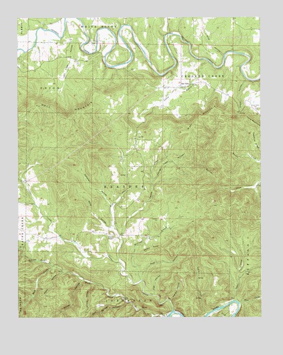
Rea Valley, AR USGS Topographic Map
Click on map above to begin viewing in our Map Viewer.

This topographic map contains these locations and features:
Feature Name Type Latitude Longitude GNIS ID View Map
Barney HollowValleyN36.1406°W92.5918°46115View Map
Bear HollowValleyN36.1256°W92.5549°46227View Map
Blind ChuteChannelN36.1259°W92.5146°70046View Map
Blue John CreekStreamN36.1481°W92.5732°46753View Map
Boat CreekStreamN36.1306°W92.5113°70748View Map
Cabin CreekStreamN36.1265°W92.5271°47259View Map
Campbell HollowValleyN36.1712°W92.5771°47351View Map
Cedar CreekStreamN36.1320°W92.5138°71080View Map
Clabber CreekStreamN36.1278°W92.5452°47792View Map
Clabber Creek ShoalBarN36.1270°W92.5441°70053View Map
Cold Spring HollowValleyN36.1312°W92.5696°47909View Map
Coldwater HollowValleyN36.1303°W92.6213°47912View Map
Elbow HollowValleyN36.1431°W92.6021°48837View Map
Elbow HollowValleyN36.2240°W92.5066°48838View Map
Flat HollowValleyN36.1340°W92.5552°49108View Map
George Treat HollowValleyN36.1817°W92.5563°49376View Map
Hall MountainSummitN36.2137°W92.6152°57867View Map
Hamlet School (historical)SchoolN36.1617°W92.6232°81913View Map
Hand Valley CemeteryCemeteryN36.2123°W92.5029°49817View Map
Ingram CreekStreamN36.1595°W92.5727°50508View Map
John Treat HollowValleyN36.2398°W92.5902°50662View Map
Leader HollowValleyN36.1317°W92.5468°51029View Map
Little Rush CreekStreamN36.1465°W92.6071°51325View Map
Ott CemeteryCemeteryN36.1745°W92.5657°1721321View Map
Pine HollowValleyN36.1415°W92.5624°53444View Map
Pine HollowValleyN36.2342°W92.5188°53447View Map
Poison PointCliffN36.1537°W92.5549°53648View Map
Rea ValleyPopulated PlaceN36.2212°W92.5413°57165View Map
Rea Valley Baptist ChurchChurchN36.2206°W92.5441°61010View Map
Rea Valley School (historical)SchoolN36.2206°W92.5441°81915View Map
Rea Valley Volunteer Fire DepartmentBuildingN36.2209°W92.5505°2117017View Map
Rea Valley Volunteer Fire Department Station 2BuildingN36.2103°W92.5010°2119191View Map
RushPopulated PlaceN36.1331°W92.5710°57174View Map
Rush Historic DistrictParkN36.1326°W92.5710°66376View Map
Rush School (historical)SchoolN36.1367°W92.5788°81914View Map
Shop HollowValleyN36.1620°W92.5754°54820View Map
Township of Bearden (historical)CivilN36.1751°W92.5793°69624View Map
Township of Crooked Creek (historical)CivilN36.2181°W92.5085°69631View Map
Valley BranchStreamN36.2326°W92.5279°55871View Map
Wares ChapelLocaleN36.1584°W92.5760°56058View Map
Williams BranchStreamN36.1398°W92.5610°56382View Map
Williams CemeteryCemeteryN36.1659°W92.5532°56391View Map
Wilson HollowValleyN36.1392°W92.5852°56446View Map

Note: Coordinates in the location and feature list above are referenced to NAD83 datum.


Copyright (C) 2008-2024 Ryan Niemi / Sunset Dynamics ... All Rights Reserved