TopoQuest Logo
Do you find TopoQuest useful?
Help keep TopoQuest running and adding new maps/features by donating!
Bitcoin:  19c7KJd3qBynnjoSw5npx9KScwjBe4ifkT
Litecoin:  LXs6TkuXGGXo1vDsWCkWVdjQX94eUKd6ui
Home View Maps Find Maps Find Places Resources & Links


Wakefield, Ohio Topographic Map

USGS Map Title: Wakefield, OH
USGS Map MRC: 38083H1
DRG (GeoTIFF) Download: o38083h1.tif


Neighboring USGS Topographic Map Quads:


  Latham, OH  
39083A2
 

  Piketon, OH  
39083A1
 

  Waverly South, OH  
39082A8
 

  Rarden, OH  
38083H2
 

  Wakefield, OH  
38083H1
 

  Lucasville, OH  
38082H8
 

  Otway, OH  
38083G2
 

  West Portsmouth, OH  
38083G1
 

  New Boston, OH  
38082G8


Map MRC Location:

N39°
W84°
N39°
W83°
H8 H7 H6 H5 H4 H3 H2 H1
G8 G7 G6 G5 G4 G3 G2 G1
F8 F7 F6 F5 F4 F3 F2 F1
E8 E7 E6 E5 E4 E3 E2 E1
D8 D7 D6 D5 D4 D3 D2 D1
C8 C7 C6 C5 C4 C3 C2 C1
B8 B7 B6 B5 B4 B3 B2 B1
A8 A7 A6 A5 A4 A3 A2 A1
N38°
W84°
N38°
W83°

Wakefield, OH USGS 1:24K Topographic Map Preview:
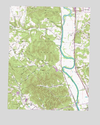
Wakefield, OH USGS Topographic Map
Click on map above to begin viewing in our Map Viewer.

This topographic map contains these locations and features:
Feature Name Type Latitude Longitude GNIS ID View Map
Bean HollowValleyN38.9248°W83.0782°1037713View Map
Bear CreekPopulated PlaceN38.9312°W83.0657°1064395View Map
Bear CreekStreamN38.9215°W83.0388°1037717View Map
Bear Creek School (historical)SchoolN38.9245°W83.0791°1049483View Map
Bearcreek Post Office (historical)Post OfficeN38.9306°W83.0652°2043955View Map
Big RunStreamN38.9584°W83.0427°1829085View Map
Big RunStreamN38.8862°W83.0193°1038015View Map
Big Run CemeteryCemeteryN38.9028°W83.0421°1038034View Map
Big Run ChurchChurchN38.9040°W83.0755°1038036View Map
Big Run ChurchChurchN38.9067°W83.0418°1038037View Map
Bonds Trailer CourtPopulated PlaceN38.9683°W83.0261°2568285View Map
CampPopulated PlaceN38.9737°W83.1152°1048575View Map
Camp CreekStreamN38.9526°W83.0441°1038682View Map
Camp Creek ChurchChurchN38.9740°W83.0896°1038687View Map
Camp Creek ChurchChurchN38.9742°W83.1202°1038688View Map
Camp Creek Township Volunteer Fire DepartmentBuildingN38.9741°W83.1156°2550409View Map
Camp Post Office (historical)Post OfficeN38.9737°W83.1146°2042454View Map
CliffordPopulated PlaceN38.9267°W83.0196°1048606View Map
Clifford Post Office (historical)Post OfficeN38.9265°W83.0193°2044025View Map
CoopersvillePopulated PlaceN38.9612°W83.0427°1039355View Map
Coopersville Post Office (historical)Post OfficeN38.9612°W83.0430°2042456View Map
CrabtreePopulated PlaceN38.8926°W83.1043°1062719View Map
Crabtree Post Office (historical)Post OfficeN38.8917°W83.1041°2044020View Map
Dawsons Mobile Home ParkPopulated PlaceN38.9903°W83.0217°2544740View Map
Devers RunStreamN38.8823°W83.0182°1039686View Map
Doll School (historical)SchoolN38.8762°W83.0166°1049480View Map
Ganderhook CreekStreamN38.9753°W83.0424°1040750View Map
Goldust HillSummitN38.9609°W83.0088°1048792View Map
Henderson KnobSummitN38.9231°W83.0685°1041483View Map
Hidden Quarry AirportAirportN38.8941°W83.1134°1082812View Map
Hiles HollowValleyN38.9315°W83.0674°1041574View Map
Howard Number 2 CemeteryCemeteryN38.9673°W83.0524°1963407View Map
Howard United Methodist ChurchChurchN38.9667°W83.0518°1041829View Map
Lake FrasureReservoirN38.9249°W83.0517°1078129View Map
Lake Frasure DamDamN38.9217°W83.0482°1078128View Map
Lauman CemeteryCemeteryN38.9228°W83.0427°1964231View Map
Lower Bear Creek School (historical)SchoolN38.9248°W83.0493°1049481View Map
Martin CemeteryCemeteryN38.8906°W83.0993°1043021View Map
McChesney RidgeRidgeN38.9184°W83.1132°1043152View Map
Merritt CemeteryCemeteryN38.9742°W83.1157°1043233View Map
Miller CemeteryCemeteryN38.9475°W83.0242°1043348View Map
Miller RunStreamN38.8992°W83.0155°1067090View Map
Morgan Elementary SchoolSchoolN38.9329°W83.0899°1049484View Map
Morgan Township Volunteer Fire DepartmentBuildingN38.9328°W83.0901°2550370View Map
Mount Ettney CemeteryCemeteryN38.9865°W83.1171°1043559View Map
Mount Zion Number 3 CemeteryCemeteryN38.9732°W83.0665°1963417View Map
Northwest High SchoolSchoolN38.8817°W83.0885°1043992View Map
Pleasant Valley ChurchChurchN38.9020°W83.1074°1044595View Map
Pleasant Valley School (historical)SchoolN38.8970°W83.1049°1049485View Map
Rapp HollowValleyN38.9806°W83.0010°1044861View Map
Rhymby CemeteryCemeteryN38.9390°W83.0991°1044963View Map
Rockwell CemeteryCemeteryN38.8923°W83.1021°1045125View Map
Rocky ForkStreamN38.9701°W83.0932°1045133View Map
Russell Number 2 CemeteryCemeteryN38.9848°W83.0641°1084046View Map
Salt CreekStreamN38.9723°W83.0143°1045910View Map
School Number 6 (historical)SchoolN38.9034°W83.0688°1049482View Map
Scioto Ambulance DistrictBuildingN38.9328°W83.0900°2550891View Map
Scioto County FairgroundsLocaleN38.9034°W83.0041°1049479View Map
Scioto SchoolSchoolN38.9659°W83.0282°1046041View Map
SedanPopulated PlaceN38.9476°W83.1182°1063006View Map
Sedan Post Office (historical)Post OfficeN38.9473°W83.1180°2044054View Map
Slate RunStreamN38.8951°W83.0238°1046336View Map
Starr HollowValleyN38.9926°W83.0482°1046644View Map
Township of MorganCivilN38.9233°W83.0843°1086929View Map
Union Township Volunteer Fire DepartmentBuildingN38.8925°W83.1150°2550296View Map
WakefieldPopulated PlaceN38.9703°W83.0199°1049286View Map
Wakefield Post OfficePost OfficeN38.9709°W83.0193°2044274View Map
Welcome ChapelChurchN38.9279°W83.0202°1047661View Map
WetmorePopulated PlaceN38.9584°W83.0238°1062596View Map
Wetmore Post Office (historical)Post OfficeN38.9584°W83.0235°2044272View Map
Wheeler HollowValleyN38.9742°W83.0785°1067181View Map
Wildcat HollowValleyN38.9284°W83.0838°1047904View Map
Zion ChurchChurchN38.8929°W83.1074°1048263View Map

Note: Coordinates in the location and feature list above are referenced to NAD83 datum.


Copyright (C) 2008-2024 Ryan Niemi / Sunset Dynamics ... All Rights Reserved